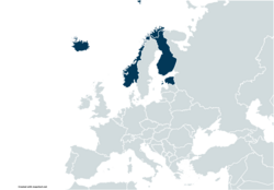
Circles of latitude between the 55th parallel north and the 60th parallel north
In-game article clicks load inline without leaving the challenge.
Following are circles of latitude between the 55th parallel north and the 60th parallel north:
56th parallel north

The 56th parallel north is a circle of latitude that is 56 degrees north of the Earth's equatorial plane. It crosses Europe, Asia, the Pacific Ocean, North America, and the Atlantic Ocean.
At this latitude the sun is visible for 17 hours, 37 minutes during the summer solstice and 6 hours, 57 minutes during the winter solstice.
Around the world
Starting at the Prime Meridian and heading eastwards, the parallel 56° north passes through:
Coordinates Country, territory or sea Notes 56°0′N 0°0′E/56.000°N 0.000°E/ 56.000; 0.000(Prime Meridian) North Sea 56°0′N 8°7′E/56.000°N 8.117°E/ 56.000; 8.117(Denmark) Denmark Jutland (mainland) 56°0′N 10°17′E/56.000°N 10.283°E/ 56.000; 10.283(Kattegat) Kattegat 56°0′N 10°33′E/56.000°N 10.550°E/ 56.000; 10.550(Denmark) Denmark Island of Samsø, passing through the northern tip for about 400 meters 56°0′N 10°33′E/56.000°N 10.550°E/ 56.000; 10.550(Kattegat) Kattegat 56°0′N 11°55′E/56.000°N 11.917°E/ 56.000; 11.917(Denmark) Denmark Island of Sjælland, passing just south of Helsingør 56°0′N 12°35′E/56.000°N 12.583°E/ 56.000; 12.583(Øresund) Øresund 56°0′N 12°43′E/56.000°N 12.717°E/ 56.000; 12.717(Sweden) Sweden Scania, passing just south of Helsingborg 56°0′N 14°27′E/56.000°N 14.450°E/ 56.000; 14.450(Hanöbunkten) Hanöbukten 56°0′N 14°37′E/56.000°N 14.617°E/ 56.000; 14.617(Sweden) Sweden Blekinge 56°0′N 14°44′E/56.000°N 14.733°E/ 56.000; 14.733(Baltic Sea) Baltic Sea 56°0′N 21°4′E/56.000°N 21.067°E/ 56.000; 21.067(Lithuania) Lithuania Klaipėda County 56°0′N 25°52′E/56.000°N 25.867°E/ 56.000; 25.867(Latvia) Latvia Passing just north of Daugavpils 56°0′N 27°49′E/56.000°N 27.817°E/ 56.000; 27.817(Belarus) Belarus Vitebsk Region 56°0′N 28°43′E/56.000°N 28.717°E/ 56.000; 28.717(Russia) Russia For about 13 km 56°0′N 28°55′E/56.000°N 28.917°E/ 56.000; 28.917(Belarus) Belarus For about 17 km 56°0′N 29°12′E/56.000°N 29.200°E/ 56.000; 29.200(Russia) Russia Passing just north of Moscow 56°0′N 137°25′E/56.000°N 137.417°E/ 56.000; 137.417(Sea of Okhotsk) Sea of Okhotsk 56°0′N 155°40′E/56.000°N 155.667°E/ 56.000; 155.667(Russia) Russia Kamchatka Peninsula 56°0′N 162°5′E/56.000°N 162.083°E/ 56.000; 162.083(Bering Sea) Bering Sea 56°0′N 160°34′W/56.000°N 160.567°W/ 56.000; -160.567(United States) United States Alaska - the Alaska Peninsula 56°0′N 158°25′W/56.000°N 158.417°W/ 56.000; -158.417(Pacific Ocean) Pacific Ocean Gulf of Alaska - passing just south of the Semidi Islands, and just north of Chirikof Island, Alaska, United States Passing just south of Kuiu Island, Alaska, United States 56°0′N 133°35′W/56.000°N 133.583°W/ 56.000; -133.583(United States) United States Alaska - Kosciusko Island, Prince of Wales Island, Etolin Island and the Alaska Panhandle 56°0′N 130°1′W/56.000°N 130.017°W/ 56.000; -130.017(Canada) Canada British Columbia - passing 2.5 km south of Hudson's Hope Alberta Saskatchewan Manitoba - passing just North of Thompson Ontario - passing just north of Fort Severn 56°0′N 87°26′W/56.000°N 87.433°W/ 56.000; -87.433(Hudson Bay) Hudson Bay 56°0′N 79°53′W/56.000°N 79.883°W/ 56.000; -79.883(Canada) Canada Nunavut - Flaherty Island and Innetalling Island 56°0′N 78°59′W/56.000°N 78.983°W/ 56.000; -78.983(Hudson Bay) Hudson Bay 56°0′N 76°46′W/56.000°N 76.767°W/ 56.000; -76.767(Canada) Canada Quebec Newfoundland and Labrador 56°0′N 60°49′W/56.000°N 60.817°W/ 56.000; -60.817(Atlantic Ocean) Atlantic Ocean 56°0′N 6°0′W/56.000°N 6.000°W/ 56.000; -6.000(United Kingdom) United Kingdom Scotland - Island of Jura 56°0′N 5°48′W/56.000°N 5.800°W/ 56.000; -5.800(Sound of Jura) Sound of Jura 56°0′N 5°41′W/56.000°N 5.683°W/ 56.000; -5.683(United Kingdom) United Kingdom Scotland, passing through Helensburgh and then Falkirk town centre 56°0′N 3°21′W/56.000°N 3.350°W/ 56.000; -3.350(Firth of Forth) Firth of Forth Passing through the Forth Bridge, and just north of Edinburgh 56°0′N 2°53′W/56.000°N 2.883°W/ 56.000; -2.883(United Kingdom) United Kingdom Scotland, passing through Dunbar 56°0′N 2°30′W/56.000°N 2.500°W/ 56.000; -2.500(North Sea) North Sea
57th parallel north
The 57th parallel north is a circle of latitude that is 57 degrees north of the Earth's equatorial plane. It crosses Europe, Asia, the Pacific Ocean, North America, and the Atlantic Ocean.
At this latitude the sun is visible for 17 hours, 53 minutes during the summer solstice and 6 hours, 43 minutes during the winter solstice. On June 21, the sun is at 56.44 degrees in the sky and on December 21, the sun is at 9.56 degrees in the sky. During the summer solstice, nighttime does not get beyond nautical twilight, a condition which lasts throughout the month of June. It is possible to view both astronomical dawn and dusk every day of the month of April.
The maximum altitude of the Sun is > 18.00º in October and > 11.00º in November.
The only capital city on the 57th parallel north is Riga.
Around the world
Starting at the Prime Meridian and heading eastwards, the parallel 57° north passes through:
Coordinates Country, territory or ocean Notes 57°0′N 0°0′E/57.000°N 0.000°E/ 57.000; 0.000(Prime Meridian) Atlantic Ocean North Sea 57°0′N 8°26′E/57.000°N 8.433°E/ 57.000; 8.433(Denmark) Denmark North Jutlandic Island and Jutland mainland 57°0′N 10°21′E/57.000°N 10.350°E/ 57.000; 10.350(Kattegat) Atlantic Ocean Kattegat 57°0′N 12°21′E/57.000°N 12.350°E/ 57.000; 12.350(Sweden) Sweden Halland, Jönköping, Kronoberg and Kalmar counties 57°0′N 16°32′E/57.000°N 16.533°E/ 57.000; 16.533(Kalmar Strait) Atlantic Ocean Kalmar Strait, Baltic Sea 57°0′N 16°47′E/57.000°N 16.783°E/ 57.000; 16.783(Sweden) Sweden Island of Öland 57°0′N 16°55′E/57.000°N 16.917°E/ 57.000; 16.917(Baltic Sea) Atlantic Ocean Baltic Sea 57°0′N 18°13′E/57.000°N 18.217°E/ 57.000; 18.217(Sweden) Sweden Island of Gotland 57°0′N 18°24′E/57.000°N 18.400°E/ 57.000; 18.400(Baltic Sea) Atlantic Ocean Baltic Sea 57°0′N 21°22′E/57.000°N 21.367°E/ 57.000; 21.367(Latvia) Latvia Courland, Semigallia 57°0′N 23°32′E/57.000°N 23.533°E/ 57.000; 23.533(Gulf of Riga) Atlantic Ocean Gulf of Riga, Baltic Sea 57°0′N 23°54′E/57.000°N 23.900°E/ 57.000; 23.900(Latvia) Latvia Passing through Riga. Vidzeme, Latgale 57°0′N 27°43′E/57.000°N 27.717°E/ 57.000; 27.717(Russia) Russia Passing through Ivanovo 57°0′N 138°45′E/57.000°N 138.750°E/ 57.000; 138.750(Sea of Okhotsk) Pacific Ocean Sea of Okhotsk 57°0′N 156°31′E/57.000°N 156.517°E/ 57.000; 156.517(Russia) Russia Kamchatka Peninsula 57°0′N 162°51′E/57.000°N 162.850°E/ 57.000; 162.850(Bering Sea) Pacific Ocean Bering Sea Passing just south of Otter Island and Saint Paul Island, Alaska, United States 57°0′N 158°40′W/57.000°N 158.667°W/ 57.000; -158.667(United States) United States Alaska - Alaska Peninsula 57°0′N 156°33′W/57.000°N 156.550°W/ 57.000; -156.550(Pacific Ocean) Pacific Ocean Gulf of Alaska 57°0′N 154°32′W/57.000°N 154.533°W/ 57.000; -154.533(United States) United States Alaska - Kodiak Island and Sitkalidak Island 57°0′N 153°17′W/57.000°N 153.283°W/ 57.000; -153.283(Pacific Ocean) Pacific Ocean Gulf of Alaska 57°0′N 135°50′W/57.000°N 135.833°W/ 57.000; -135.833(United States) United States Alaska - Kruzof Island 57°0′N 135°45′W/57.000°N 135.750°W/ 57.000; -135.750(Sitka Sound) Pacific Ocean Sitka Sound 57°0′N 135°15′W/57.000°N 135.250°W/ 57.000; -135.250(United States) United States Alaska - Baranof Island 57°0′N 134°43′W/57.000°N 134.717°W/ 57.000; -134.717(Chatham Strait) Pacific Ocean Chatham Strait Passing just south of Admiralty Island, Alaska, United States 57°0′N 134°30′W/57.000°N 134.500°W/ 57.000; -134.500(Frederick Sound) Frederick Sound 57°0′N 134°0′W/57.000°N 134.000°W/ 57.000; -134.000(United States) United States Alaska - Kupreanof Island and the Alaska Panhandle 57°0′N 132°3′W/57.000°N 132.050°W/ 57.000; -132.050(Canada) Canada British Columbia, Alberta, Saskatchewan, Manitoba 57°0′N 89°54′W/57.000°N 89.900°W/ 57.000; -89.900(Hudson Bay) Arctic Ocean Hudson Bay Passing just north of the Belcher Islands, Nunavut, Canada 57°0′N 76°42′W/57.000°N 76.700°W/ 57.000; -76.700(Canada) Canada Nunavut, Quebec, Newfoundland and Labrador 57°0′N 61°22′W/57.000°N 61.367°W/ 57.000; -61.367(Atlantic Ocean) Atlantic Ocean 57°0′N 7°31′W/57.000°N 7.517°W/ 57.000; -7.517(United Kingdom) United Kingdom Island of Barra, Scotland 57°0′N 7°22′W/57.000°N 7.367°W/ 57.000; -7.367(Sea of the Hebrides) Atlantic Ocean Sea of the Hebrides 57°0′N 6°27′W/57.000°N 6.450°W/ 57.000; -6.450(United Kingdom) United Kingdom Island of Rùm, Scotland 57°0′N 6°15′W/57.000°N 6.250°W/ 57.000; -6.250(Sea of the Hebrides) Atlantic Ocean Sea of the Hebrides 57°0′N 5°50′W/57.000°N 5.833°W/ 57.000; -5.833(United Kingdom) United Kingdom Scotland 57°0′N 2°10′W/57.000°N 2.167°W/ 57.000; -2.167(North Sea) Atlantic Ocean North Sea
58th parallel north
The 58th parallel north is a circle of latitude that is 58 degrees north of the Earth's equatorial plane. It crosses Europe, Asia, the Pacific Ocean, North America, and the Atlantic Ocean.
At this latitude the Sun is visible for 18 hours, 11 minutes during the summer solstice and 6 hours, 27 minutes during the winter solstice.
Around the world
Starting at the Prime Meridian and heading eastwards, the parallel 58° north passes through:
Coordinates Country, territory or ocean Notes 58°0′N 0°0′E/58.000°N 0.000°E/ 58.000; 0.000(Prime Meridian) North Sea 58°0′N 6°59′E/58.000°N 6.983°E/ 58.000; 6.983(Norway) Norway Markøy and Austre Seli, Vest-Agder 58°0′N 7°0′E/58.000°N 7.000°E/ 58.000; 7.000(North Sea) Atlantic Ocean North Sea 58°0′N 7°2′E/58.000°N 7.033°E/ 58.000; 7.033(Norway) Norway Lindesnes peninsula, Vest-Agder Passing 2.3 km (1.4 mi) north of mainland Norway's southernmost point 58°0′N 7°6′E/58.000°N 7.100°E/ 58.000; 7.100(Skagerrak) Atlantic Ocean Skagerrak Passing between Våre Island to the north and Udvåre Island to the south, Vest-Agder 58°0′N 7°20′E/58.000°N 7.333°E/ 58.000; 7.333(Norway) Norway Hille Island, Vest-Agder 58°0′N 7°23′E/58.000°N 7.383°E/ 58.000; 7.383(Skagerrak) Atlantic Ocean Skagerrak 58°0′N 7°30′E/58.000°N 7.500°E/ 58.000; 7.500(Norway) Norway Skjernøy Island, Vest-Agder 58°0′N 7°32′E/58.000°N 7.533°E/ 58.000; 7.533(Skagerrak) Atlantic Ocean Skagerrak Passing south of Uvår and Songvår Islands, Vest-Agder 58°0′N 11°32′E/58.000°N 11.533°E/ 58.000; 11.533(Sweden) Sweden Tjörn Island, Västra Götaland County 58°0′N 11°45′E/58.000°N 11.750°E/ 58.000; 11.750(Hakefjorden) Atlantic Ocean Hakefjorden 58°0′N 11°49′E/58.000°N 11.817°E/ 58.000; 11.817(Sweden) Sweden Västra Götaland County, Lake Vättern (southernmost point of Visingsö), Jönköping County, Östergötland County, Kalmar County 58°0′N 16°47′E/58.000°N 16.783°E/ 58.000; 16.783(Baltic Sea) Atlantic Ocean Baltic Sea Passing just north of the islands of Gotland and Fårö, Sweden 58°0′N 22°1′E/58.000°N 22.017°E/ 58.000; 22.017(Estonia) Estonia Island of Saaremaa, Saare County 58°0′N 22°11′E/58.000°N 22.183°E/ 58.000; 22.183(Gulf of Riga) Atlantic Ocean Gulf of Riga, Baltic Sea 58°0′N 24°25′E/58.000°N 24.417°E/ 58.000; 24.417(Estonia) Estonia Pärnu County 58°0′N 24°55′E/58.000°N 24.917°E/ 58.000; 24.917(Latvia) Latvia For 19.8 km (12.3 mi), Valmiera district 58°0′N 25°15′E/58.000°N 25.250°E/ 58.000; 25.250(Estonia) Estonia For 2.7 km (1.7 mi), Viljandi County 58°0′N 25°18′E/58.000°N 25.300°E/ 58.000; 25.300(Latvia) Latvia For 8.6 km (5.3 mi), Valmiera district 58°0′N 25°27′E/58.000°N 25.450°E/ 58.000; 25.450(Estonia) Estonia Viljandi County, Valga County and Põlva County 58°0′N 27°41′E/58.000°N 27.683°E/ 58.000; 27.683(Russia) Russia Northwestern, Central, Volga, Ural Federal Districts, Krasnoyarsk Krai, Irkutsk Oblast, Zabaykalsky Krai, Zabaykalsky Krai, Yakutia, Khabarovsk Krai Passing through Perm and Ust-Ilimsk 58°0′N 140°33′E/58.000°N 140.550°E/ 58.000; 140.550(Sea of Okhotsk) Pacific Ocean Sea of Okhotsk 58°0′N 157°40′E/58.000°N 157.667°E/ 58.000; 157.667(Russia) Russia Kamchatka Peninsula, Kamchatka Krai 58°0′N 161°59′E/58.000°N 161.983°E/ 58.000; 161.983(Bering Sea) Pacific Ocean Bering Sea 58°0′N 157°37′W/58.000°N 157.617°W/ 58.000; -157.617(United States) United States Alaska - Alaska Peninsula 58°0′N 155°2′W/58.000°N 155.033°W/ 58.000; -155.033(Shelikof Strait) Pacific Ocean Shelikof Strait, Gulf of Alaska 58°0′N 153°5′W/58.000°N 153.083°W/ 58.000; -153.083(United States) United States Alaska - Raspberry Island and Afognak Island 58°0′N 152°47′W/58.000°N 152.783°W/ 58.000; -152.783(Pacific Ocean) Pacific Ocean Gulf of Alaska 58°0′N 136°31′W/58.000°N 136.517°W/ 58.000; -136.517(United States) United States Alaska - Yakobi Island, Chichagof Island, Admiralty Island and the mainland 58°0′N 133°3′W/58.000°N 133.050°W/ 58.000; -133.050(Canada) Canada British Columbia, Alberta, Saskatchewan, Manitoba 58°0′N 92°49′W/58.000°N 92.817°W/ 58.000; -92.817(Hudson Bay) Arctic Ocean Hudson Bay 58°0′N 77°12′W/58.000°N 77.200°W/ 58.000; -77.200(Canada) Canada Quebec, Newfoundland and Labrador 58°0′N 62°9′W/58.000°N 62.150°W/ 58.000; -62.150(Atlantic Ocean) Atlantic Ocean 58°0′N 7°6′W/58.000°N 7.100°W/ 58.000; -7.100(United Kingdom) United Kingdom Island of Lewis and Harris, Scotland 58°0′N 6°23′W/58.000°N 6.383°W/ 58.000; -6.383(The Minch) The Minch 58°0′N 5°19′W/58.000°N 5.317°W/ 58.000; -5.317(United Kingdom) United Kingdom Scotland 58°0′N 3°52′W/58.000°N 3.867°W/ 58.000; -3.867(North Sea) North Sea
Climate
In general, this parallel sees significant differences in temperature and precipitation with proximity to warm ocean currents. The moderation from the Gulf Stream ensures a moderate oceanic climate in much of Western Europe and on the immediate coastline of Alaska, whereas moving inland on continental masses, subarctic climates predominate as the dark winters dominate the temperature cycle. In the transitional area centred on the Baltic Sea this latitude sees a humid continental climate with warm summers and snowy winters somewhat below freezing.
Where cold ocean currents dominate such as near Hudson Bay the climate is polar, rendering in severe winter conditions and very subdued summers. This type of climate is seen in the surroundings of Inukjuak in Quebec, Canada, where the sea ice eliminates winter moderation, but the thawing of the cold water renders in very cool summers as well. In more continental cold areas such as these winters commonly go below −30 °C or −22 °F even during the day. Further west in inland areas winters are often as severe, but summers average above 22 °C or 71.6 °F, similar to the Baltic region where climates are much gentler.
59th parallel north
The 59th parallel north is a circle of latitude that is 59 degrees north of the Earth's equatorial plane. It crosses Europe, Asia, the Pacific Ocean, North America, and the Atlantic Ocean.
At this latitude the Sun is visible for 18 hours, 30 minutes during the summer solstice and 6 hours, 11 minutes during the winter solstice.
If latitude in northern hemisphere is 59°45′ or smaller, every day in August can view both nautical dawn and nautical dusk.
Around the world
Starting at the Prime Meridian and heading eastwards, the parallel 59° north passes through:
Coordinates Country, territory or oceans Notes 59°0′N 0°0′E/59.000°N 0.000°E/ 59.000; 0.000(Prime Meridian) Atlantic Ocean North Sea 59°0′N 5°34′E/59.000°N 5.567°E/ 59.000; 5.567(Norway) Norway Jæren, Rogaland 59°0′N 5°40′E/59.000°N 5.667°E/ 59.000; 5.667(North Sea) Atlantic Ocean Byfjorden, Boknafjorden 59°0′N 5°34′E/59.000°N 5.567°E/ 59.000; 5.567(Norway) Norway Hundvåg and Vassøy Islands, Rogaland 59°0′N 5°48′E/59.000°N 5.800°E/ 59.000; 5.800(North Sea) Atlantic Ocean Idsefjorden, Boknafjorden 59°0′N 6°4′E/59.000°N 6.067°E/ 59.000; 6.067(Norway) Norway Rogaland, Vest-Agder, Aust-Agder, Telemark 59°0′N 9°45′E/59.000°N 9.750°E/ 59.000; 9.750(Skagerrak) Atlantic Ocean Langesundsfjorden, Skagerrak Passing over Langøya, Geiterøya, Store Arøya and Stokkøya islands 59°0′N 9°51′E/59.000°N 9.850°E/ 59.000; 9.850(Norway) Norway Vestfold 59°0′N 10°3′E/59.000°N 10.050°E/ 59.000; 10.050(Skagerrak) Atlantic Ocean Skagerrak Passing south of Ferder lighthouse and Oslofjorden 59°0′N 11°2′E/59.000°N 11.033°E/ 59.000; 11.033(Norway) Norway Andholmen and Søndre Sandøy, Hvaler islands, Østfold 59°0′N 10°3′E/59.000°N 10.050°E/ 59.000; 10.050(Skagerrak) Atlantic Ocean Sekken sound, Skagerrak for 1.9 km 59°0′N 11°7′E/59.000°N 11.117°E/ 59.000; 11.117(Sweden) Sweden Strömstad Municipality, Västra Götaland County for 19 km 59°0′N 11°27′E/59.000°N 11.450°E/ 59.000; 11.450(Skagerrak) Atlantic Ocean Iddefjord, Skagerrak for 1 km 59°0′N 11°28′E/59.000°N 11.467°E/ 59.000; 11.467(Norway) Norway Halden Municipality for 13.6 km 59°0′N 11°42′E/59.000°N 11.700°E/ 59.000; 11.700(Sweden) Sweden Västra Götaland County, Lake Vänern, Värmland County, Örebro County, Södermanland County, Stockholm County 59°0′N 18°12′E/59.000°N 18.200°E/ 59.000; 18.200(Baltic Sea) Atlantic Ocean Baltic Sea 59°0′N 22°30′E/59.000°N 22.500°E/ 59.000; 22.500(Estonia) Estonia Island of Hiiumaa 59°0′N 22°52′E/59.000°N 22.867°E/ 59.000; 22.867(Baltic Sea) Atlantic Ocean Baltic Sea 59°0′N 23°8′E/59.000°N 23.133°E/ 59.000; 23.133(Estonia) Estonia Island of Vormsi and the mainland. Passing through Lake Peipus 59°0′N 27°44′E/59.000°N 27.733°E/ 59.000; 27.733(Russia) Russia Passing through Rybinsk Reservoir 59°0′N 142°2′E/59.000°N 142.033°E/ 59.000; 142.033(Sea of Okhotsk) Pacific Ocean Sea of Okhotsk 59°0′N 150°29′E/59.000°N 150.483°E/ 59.000; 150.483(Russia) Russia Zavyalov Island 59°0′N 150°36′E/59.000°N 150.600°E/ 59.000; 150.600(Sea of Okhotsk) Pacific Ocean Sea of Okhotsk 59°0′N 151°14′E/59.000°N 151.233°E/ 59.000; 151.233(Russia) Russia 59°0′N 152°57′E/59.000°N 152.950°E/ 59.000; 152.950(Sea of Okhotsk) Pacific Ocean Sea of Okhotsk 59°0′N 159°44′E/59.000°N 159.733°E/ 59.000; 159.733(Russia) Russia Kamchatka Peninsula 59°0′N 163°5′E/59.000°N 163.083°E/ 59.000; 163.083(Bering Sea) Pacific Ocean Litke Strait, Bering Sea 59°0′N 163°54′E/59.000°N 163.900°E/ 59.000; 163.900(Russia) Russia Karaginsky Island 59°0′N 164°43′E/59.000°N 164.717°E/ 59.000; 164.717(Bering Sea) Pacific Ocean Bering Sea 59°0′N 161°49′W/59.000°N 161.817°W/ 59.000; -161.817(United States) United States Alaska 59°0′N 153°36′W/59.000°N 153.600°W/ 59.000; -153.600(Pacific Ocean) Pacific Ocean Gulf of Alaska - passing just north of the Barren Islands 59°0′N 138°10′W/59.000°N 138.167°W/ 59.000; -138.167(United States) United States Alaska 59°0′N 137°30′W/59.000°N 137.500°W/ 59.000; -137.500(Canada) Canada British Columbia - for about 13 km (8.1 mi) 59°0′N 137°16′W/59.000°N 137.267°W/ 59.000; -137.267(United States) United States Alaska 59°0′N 134°24′W/59.000°N 134.400°W/ 59.000; -134.400(Canada) Canada British Columbia, Alberta, Saskatchewan, Manitoba (not far north of Churchill). 59°0′N 94°43′W/59.000°N 94.717°W/ 59.000; -94.717(Hudson Bay) Arctic Ocean Hudson Bay Passing just south of the Ottawa Islands, Nunavut, Canada 59°0′N 78°21′W/59.000°N 78.350°W/ 59.000; -78.350(Canada) Canada Nunavut, Quebec 59°0′N 68°58′W/59.000°N 68.967°W/ 59.000; -68.967(Ungava Bay) Arctic Ocean Ungava Bay 59°0′N 65°54′W/59.000°N 65.900°W/ 59.000; -65.900(Canada) Canada Nunavut, Quebec, Newfoundland and Labrador 59°0′N 63°13′W/59.000°N 63.217°W/ 59.000; -63.217(Atlantic Ocean) Atlantic Ocean 59°0′N 3°22′W/59.000°N 3.367°W/ 59.000; -3.367(United Kingdom) United Kingdom Mainland, Orkney, Scotland 59°0′N 2°55′W/59.000°N 2.917°W/ 59.000; -2.917(North Sea) Arctic Ocean North Sea
Notable cities and towns on 59°N
60th parallel north

The 60th parallel north is a circle of latitude that is 60 degrees north of Earth's equator. It crosses Europe, Asia, the Pacific Ocean, North America, and the Atlantic Ocean.
In Canada, the 60th parallel forms the southern mainland boundary of the northern territories of Yukon, Northwest Territories, and Nunavut with the western provinces of British Columbia, Alberta, Saskatchewan, and Manitoba. Accordingly, "north of 60" is an expression often used for the territories. The 60th Parallel Territorial Park is on Mackenzie Highway between Alberta and Northwest Territories and it has a visitor centre there in the homeland of the Yellowknives Dene First Nation and the North Slave Métis Alliance.
Between 1776 and 1950, the 60th parallel formed the southern limit of the Royal Greenland Trade Department's exclusive monopoly on trade near the Dano-Norwegian and later Danish colonies of Greenland (1776–1782) and South Greenland (1782–1950).
Although it lies approximately twice as far away from the Equator as from the North Pole, the 60th parallel is half as long as the Equator line, due to the cosine of 60 degrees being 0.5. This is where the Earth bulges halfway as much as on the Equator.
At this latitude, the Sun is visible for 18 hours, 52 minutes during the June solstice and 5 hours, 52 minutes during the December solstice. The maximum altitude of the Sun is 53.44° on 21 June and 6.56° on 21 December. The maximum altitude of the Sun is > 15.00º in October and > 8.00º in November.
The lowest latitude where white nights can be observed is approximately on this parallel.
During the summer solstice, nighttime does not get beyond nautical twilight, a condition which lasts throughout the month of June. It is possible to view both astronomical dawn and dusk every day between August 22 and April 21.
Around the world
Malachy Tallack wrote a book, Sixty Degrees North: Around the World in Search of Home, about his travels along the general line of the parallel, starting and finishing at Shetland.
Starting at the Prime Meridian and heading eastwards, the parallel 60° north passes through:
Coordinates Country, territory or ocean Notes 60°0′N 0°0′E/60.000°N 0.000°E/ 60.000; 0.000(Prime Meridian) Atlantic Ocean North Sea 60°0′N 5°3′E/60.000°N 5.050°E/ 60.000; 5.050(Norway) Norway Islands of Stolmen and Selbjørn, Hordaland 60°0′N 5°12′E/60.000°N 5.200°E/ 60.000; 5.200(Prime Meridian) Atlantic Ocean Bekkjarviksundet, Selbjørnsfjorden, North Sea 60°0′N 5°15′E/60.000°N 5.250°E/ 60.000; 5.250(Norway) Norway Island of Huftarøy, Hordaland 60°0′N 5°17′E/60.000°N 5.283°E/ 60.000; 5.283(Prime Meridian) Atlantic Ocean Langenuen, North Sea 60°0′N 5°22′E/60.000°N 5.367°E/ 60.000; 5.367(Norway) Norway Islands of Reksteren, Tysnesøy and the mainland Hordaland 60°0′N 5°52′E/60.000°N 5.867°E/ 60.000; 5.867(Prime Meridian) Atlantic Ocean Hardangerfjorden, North Sea 60°0′N 5°59′E/60.000°N 5.983°E/ 60.000; 5.983(Norway) Norway Mainland: Folgefonna glacier, Telemark, Buskerud, Akershus, Oslo, Hedmark, Østfold Passing just north of the capital Oslo 60°0′N 12°23′E/60.000°N 12.383°E/ 60.000; 12.383(Sweden) Sweden Passing through Fagersta Passing just north of Uppsala 60°0′N 18°53′E/60.000°N 18.883°E/ 60.000; 18.883(Baltic Sea) Atlantic Ocean Baltic Sea 60°0′N 20°8′E/60.000°N 20.133°E/ 60.000; 20.133(Åland Islands) Finland Högskär, Bäckö and several smaller islands, Åland Islands 60°0′N 20°58′E/60.000°N 20.967°E/ 60.000; 20.967(Baltic Sea) Atlantic Ocean Baltic Sea 60°0′N 23°30′E/60.000°N 23.500°E/ 60.000; 23.500(Finland) Finland Passing through Ekenäs 60°0′N 23°58′E/60.000°N 23.967°E/ 60.000; 23.967(Baltic Sea) Atlantic Ocean Baltic Sea 60°0′N 24°26′E/60.000°N 24.433°E/ 60.000; 24.433(Finland) Finland Porkkala peninsula 60°0′N 24°30′E/60.000°N 24.500°E/ 60.000; 24.500(Baltic Sea) Atlantic Ocean Baltic Sea, Gulf of Finland Passing just south of Helsinki, Finland and the island of Gogland, Russia 60°0′N 27°48′E/60.000°N 27.800°E/ 60.000; 27.800(Russia) Russia Moshchny Island 60°0′N 27°54′E/60.000°N 27.900°E/ 60.000; 27.900(Baltic Sea) Atlantic Ocean Gulf of Finland, Baltic Sea 60°0′N 29°44′E/60.000°N 29.733°E/ 60.000; 29.733(Russia) Russia Island of Kotlin (city of Kronstadt) 60°0′N 29°47′E/60.000°N 29.783°E/ 60.000; 29.783(Baltic Sea) Atlantic Ocean Gulf of Finland, Baltic Sea 60°0′N 30°5′E/60.000°N 30.083°E/ 60.000; 30.083(Russia) Russia Passing through Saint Petersburg, Lake Ladoga 60°0′N 154°30′E/60.000°N 154.500°E/ 60.000; 154.500(Sea of Okhotsk) Pacific Ocean Shelikhov Gulf, Sea of Okhotsk 60°0′N 161°28′E/60.000°N 161.467°E/ 60.000; 161.467(Russia) Russia Kamchatka Peninsula 60°0′N 165°14′E/60.000°N 165.233°E/ 60.000; 165.233(Bering Sea) Pacific Ocean Bering Sea 60°0′N 166°10′E/60.000°N 166.167°E/ 60.000; 166.167(Russia) Russia Pylgin Range 60°0′N 166°33′E/60.000°N 166.550°E/ 60.000; 166.550(Bering Sea) Pacific Ocean Olyutor Gulf, Bering Sea 60°0′N 170°9′E/60.000°N 170.150°E/ 60.000; 170.150(Russia) Russia Olyutor Peninsula 60°0′N 170°26′E/60.000°N 170.433°E/ 60.000; 170.433(Bering Sea) Pacific Ocean Bering Sea 60°0′N 167°8′W/60.000°N 167.133°W/ 60.000; -167.133(United States) United States Alaska - Nunivak Island 60°0′N 165°39′W/60.000°N 165.650°W/ 60.000; -165.650(Etolin Strait) Pacific Ocean Etolin Strait, Bering Sea 60°0′N 164°9′W/60.000°N 164.150°W/ 60.000; -164.150(United States) United States Alaska 60°0′N 152°38′W/60.000°N 152.633°W/ 60.000; -152.633(Cook Inlet) Pacific Ocean Cook Inlet, Gulf of Alaska 60°0′N 151°44′W/60.000°N 151.733°W/ 60.000; -151.733(United States) United States Alaska - Kenai Peninsula, Evans Island, Elrington Island, Latouche Island and Montague Island 60°0′N 147°24′W/60.000°N 147.400°W/ 60.000; -147.400(Pacific Ocean) Pacific Ocean Gulf of Alaska 60°0′N 144°24′W/60.000°N 144.400°W/ 60.000; -144.400(United States) United States Alaska - Wingham Island, Kayak Island and a small section of mainland 60°0′N 143°50′W/60.000°N 143.833°W/ 60.000; -143.833(Pacific Ocean) Pacific Ocean Gulf of Alaska 60°0′N 141°53′W/60.000°N 141.883°W/ 60.000; -141.883(United States) United States Alaska 60°0′N 139°3′W/60.000°N 139.050°W/ 60.000; -139.050(Canada) Canada Yukon / British Columbia border Northwest Territories / British Columbia border Northwest Territories / Alberta border - passes through Wood Buffalo National Park and beside Fort Smith, NT Northwest Territories / Saskatchewan border Nunavut / Manitoba border 60°0′N 94°49′W/60.000°N 94.817°W/ 60.000; -94.817(Hudson Bay) Arctic Ocean Hudson Bay Passing just north of the Ottawa Islands, Nunavut, Canada 60°0′N 77°17′W/60.000°N 77.283°W/ 60.000; -77.283(Canada) Canada Quebec Passing just south of Puvirnituq, Quebec 60°0′N 69°46′W/60.000°N 69.767°W/ 60.000; -69.767(Ungava Bay) Arctic Ocean Ungava Bay Passing just south of Kangirsuk, Quebec, Canada 60°0′N 65°7′W/60.000°N 65.117°W/ 60.000; -65.117(Canada) Canada Quebec, Newfoundland and Labrador 60°0′N 64°9′W/60.000°N 64.150°W/ 60.000; -64.150 Atlantic Ocean Border between the Davis Strait (to the north) and the Labrador Sea (to the south) 60°0′N 44°52′W/60.000°N 44.867°W/ 60.000; -44.867(Greenland) Greenland Passing south of Narsaq; crossing mainland at Narsarmijit; going through Cape Farewell Archipelago, passing just north of Itilleq Island 60°0′N 43°9′W/60.000°N 43.150°W/ 60.000; -43.150(Atlantic Ocean) Atlantic Ocean 60°0′N 1°21′W/60.000°N 1.350°W/ 60.000; -1.350(United Kingdom) United Kingdom Islands of Mainland and Mousa, Shetland Islands, Scotland 60°0′N 1°11′W/60.000°N 1.183°W/ 60.000; -1.183(North Sea) Atlantic Ocean North Sea
Notable cities and towns on 60°N
- Whitehorse, Yukon, Canada
- Fort Smith, Northwest Territories, Canada
- Bergen, Vestland, Norway
- Oslo, Norway
- Helsinki, Uusimaa, Finland
- Espoo, Uusimaa, Finland
- Saint Petersburg, Russia