Arctic Archipelago
In-game article clicks load inline without leaving the challenge.
The Arctic Archipelago, also known as the Canadian Arctic Archipelago, is an archipelago lying to the north of the Canadian continental mainland, excluding Greenland (an autonomous territory of the Danish Realm, which is, by itself, much larger than the combined area of the archipelago), and Iceland (an independent country).
Situated in the northern extremity of North America and covering about 1,424,500 km2 (550,000 sq mi), this group of 36,563 islands, surrounded by the Arctic Ocean, comprises much of Northern Canada, predominately Nunavut and the Northwest Territories. The archipelago is showing some effects of climate change, with some computer estimates determining that melting there will contribute 3.5 cm (1.4 in) to the rise in sea levels by 2100.
History
Around 2500 BCE, the first humans, the Paleo-Eskimos, arrived in the archipelago from the Canadian mainland. Between 1000 and 1500 CE, they were replaced by the Thule people, who are the ancestors of today's Inuit.
British claims on the islands, the British Arctic Territories, were based on the explorations in the 1570s by Martin Frobisher. Canadian sovereignty was originally (1870–80) only over island portions that drained into Foxe Basin, Hudson Bay and Hudson Strait. Canadian sovereignty over the islands was established by 1880 when Britain transferred them to Canada. The District of Franklin—established in 1895—comprised almost all of the archipelago. The district was dissolved upon the creation of Nunavut in 1999. Canada claims all the waterways of the Northwest Passage as Canadian Internal Waters; however, most maritime countries view these as international waters.[failed verification] Disagreement over the passages' status has raised Canadian concerns about environmental enforcement, national security, and general sovereignty. East of Ellesmere Island, in the Nares Strait, lies Hans Island, ownership of which is now shared between Canada and Denmark, after a decades-long dispute.
Geography

The archipelago extends some 2,400 km (1,500 mi) longitudinally and 1,900 km (1,200 mi) from the mainland to Cape Columbia, the northernmost point on Ellesmere Island. It is bounded on the west by the Beaufort Sea; on the northwest by the Arctic Ocean; on the east by Greenland, Baffin Bay and Davis Strait; and on the south by Hudson Bay and the Canadian mainland. The various islands are separated from each other and the continental mainland by a series of waterways collectively known as the Northwest Passage. Two large peninsulas, Boothia and Melville, extend northward from the mainland. The northernmost cluster of islands, including Ellesmere Island, is known as the Queen Elizabeth Islands and was formerly the Parry Islands.
The archipelago consists of 36,563 islands, of which 94 are classified as major islands, being larger than 130 km2 (50 sq mi), and cover a total area of 1,400,000 km2 (540,000 sq mi).
The islands of the Canadian Arctic over 5,000 km2 (1,900 sq mi), in order of descending area, are: As of 2021[update] the total population of all islands in the Arctic was 23,073.
| Name (group) | Location | Area | Area rank | Pop (2021) | Notes | Coordinates | ||
|---|---|---|---|---|---|---|---|---|
| km2 | sqmi | World | Canada | |||||
| Baffin Island | Nunavut | 507,451 | 195,928 | 5 | 1 | 13,039 | Population does not include Kinngait and Qikiqtarjuaq. Both lie on small islands just off the coast of Baffin Island | 68°N 70°W/68°N 70°W/ 68; -70(Baffin Island) |
| Victoria Island | Northwest Territories, Nunavut | 217,291 | 83,897 | 8 | 2 | 2,168 | Contains the world's largest island within an island within an island | 70°25′N 107°45′W/70.417°N 107.750°W/ 70.417; -107.750(Victoria Island) |
| Ellesmere Island (Queen Elizabeth Islands) | Nunavut | 196,236 | 75,767 | 10 | 3 | 144 | Population includes Grise Fiord, Alert (Canada’s two most northerly communities) and Eureka | 79°50′N 78°00′W/79.833°N 78.000°W/ 79.833; -78.000(Ellesmere Island) |
| Banks Island | Northwest Territories | 70,028 | 27,038 | 24 | 5 | 104 | The summer home to hundreds of thousands of migratory birds who nest at Banks Island Migratory Bird Sanctuary No. 1 and Banks Island Migratory Bird Sanctuary No. 2 | 72°45′02″N 121°30′10″W/72.75056°N 121.50278°W/ 72.75056; -121.50278(Banks Island) |
| Devon Island (Queen Elizabeth Islands) | Nunavut | 55,247 | 21,331 | 27 | 6 | 0 | The largest uninhabited island on Earth | 75°15′N 088°00′W/75.250°N 88.000°W/ 75.250; -88.000(Devon Island) |
| Axel Heiberg Island (Sverdrup Islands, Queen Elizabeth Islands) | Nunavut | 43,178 | 16,671 | 32 | 7 | 0 | Known for its unusual fossil forests, which date from the Eocene period | 79°45′N 091°00′W/79.750°N 91.000°W/ 79.750; -91.000(Axel Heiberg Island) |
| Melville Island (Queen Elizabeth Islands) | Northwest Territories, Nunavut | 42,149 | 16,274 | 33 | 8 | 0 | The most northerly report of a grizzly bear sighting occurred here in 2003 | 75°30′02″N 111°30′09″W/75.50056°N 111.50250°W/ 75.50056; -111.50250(Melville Island) |
| Southampton Island | Nunavut | 41,214 | 15,913 | 34 | 9 | 1,038 | One of the few Canadian areas, and the only area in Nunavut, that does not use daylight saving time | 64°20′N 084°40′W/64.333°N 84.667°W/ 64.333; -84.667(Southampton Island) |
| Prince of Wales Island | Nunavut | 33,339 | 12,872 | 40 | 10 | 0 | North of North is set in the fictional town of Ice Cove, which is situated here | 72°40′N 99°00′W/72.667°N 99.000°W/ 72.667; -99.000(Prince of Wales Island) |
| Somerset Island | Nunavut | 24,786 | 9,570 | 46 | 12 | 0 | Home of Fort Ross (1937-1948), the last trading post established by the Hudson's Bay Company | 73°15′N 93°30′W/73.250°N 93.500°W/ 73.250; -93.500(Somerset Island) |
| Bathurst Island (Queen Elizabeth Islands) | Nunavut | 16,042 | 6,194 | 54 | 13 | 0 | Home of Brooman Point Village, Qausuittuq National Park, and the Polar Bear Pass National Wildlife Area | 75°45′N 100°00′W/75.750°N 100.000°W/ 75.750; -100.000(Bathurst Island) |
| Prince Patrick Island (Queen Elizabeth Islands) | Northwest Territories, Nunavut | 15,848 | 6,119 | 55 | 14 | 0 | Mould Bay Weather Station, part of the Joint Arctic Weather Station system between Canada and the United States opened in 1948 | 76°45′02″N 119°30′12″W/76.75056°N 119.50333°W/ 76.75056; -119.50333(Prince Patrick Island) |
| King William Island | Nunavut | 13,111 | 5,062 | 61 | 15 | 1,349 | Sir John Franklin’s two ships, HMS Erebus and HMS Terror, were found in what is now the Wrecks of HMS Erebus and HMS Terror National Historic Site | 69°10′N 97°25′W/69.167°N 97.417°W/ 69.167; -97.417(King William Island) |
| Ellef Ringnes Island (Sverdrup Islands, Queen Elizabeth Islands) | Nunavut | 11,295 | 4,361 | 68 | 16 | 0 | Isachsen, opened in 1948, formerly staffed weather station, but now an Automated Surface Observing System | 78°30′N 102°15′W/78.500°N 102.250°W/ 78.500; -102.250(Ellef Ringnes Island) |
| Bylot Island | Nunavut | 11,067 | 4,273 | 71 | 17 | 0 | Sirmilik National Park is located on the island | 73°13′N 78°34′W/73.217°N 78.567°W/ 73.217; -78.567(Bylot Island) |
| Prince Charles Island | Nunavut | 9,521 | 3,676 | 77 | 19 | 0 | Uninhabited, however Inuit visited the island to hunt caribou | 67°47′N 76°12′W/67.783°N 76.200°W/ 67.783; -76.200(Prince Charles Island) |
| Cornwallis Island (Queen Elizabeth Islands) | Nunavut | 6,995 | 2,701 | 97 | 21 | 183 | Resolute, the only community, was established in 1953 by forced migration known as the High Arctic relocation | 75°08′N 95°00′W/75.133°N 95.000°W/ 75.133; -95.000(Cornwallis Island) |
| Coats Island | Nunavut | 5,498 | 2,123 | 107 | 24 | 0 | The last home of the Sadlermiut | 62°30′N 083°00′W/62.500°N 83.000°W/ 62.500; -83.000(Coats Island) |
| Amund Ringnes Island (Sverdrup Islands Queen Elizabeth Islands) | Nunavut | 5,255 | 2,029 | 111 | 25 | 0 | 78°20′N 96°25′W/78.333°N 96.417°W/ 78.333; -96.417(Amund Ringnes Island) | |
| Mackenzie King Island (Queen Elizabeth Islands) | Northwest Territories, Nunavut | 5,048 | 1,949 | 116 | 26 | 0 | 78°02′N 109°50′W/78.033°N 109.833°W/ 78.033; -109.833(Mackenzie King Island) |
After Greenland, the archipelago is the world's largest high-Arctic land area. The climate of the islands is Arctic, and the terrain consists of tundra except in mountainous regions. Most of the islands are uninhabited; human settlement is extremely thin and scattered, being mainly coastal Inuit settlements on the southern islands.
Map with links to islands
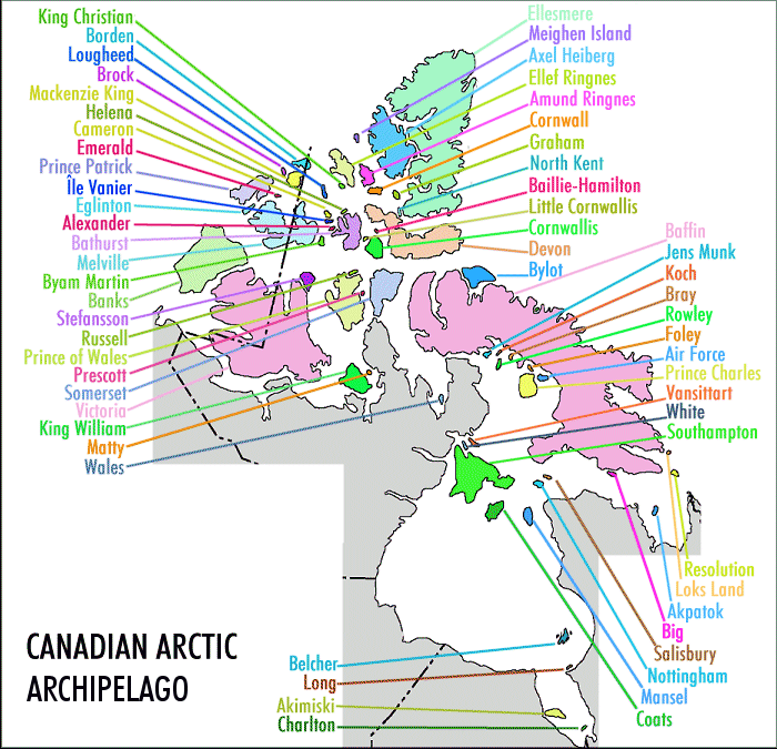
- King Christianmap 1
- Bordenmap 2
- Lougheedmap 3
- Brockmap 4
- Mackenzie Kingmap 5
- Helenamap 6
- Cameronmap 7
- Emeraldmap 8
- Prince Patrickmap 9
- Île Vaniermap 10
- Eglintonmap 11
- Alexandermap 12
- Bathurstmap 13
- Melvillemap 14
- Byam Martinmap 15
- Banksmap 16
- Stefanssonmap 17
- Russellmap 18
- Prince of Walesmap 19
- Prescottmap 20
- Somersetmap 21
- Victoriamap 22
- King Williammap 23
- Mattymap 24
- Walesmap 25
- Belchermap 26
- Longmap 27
- Akimiskimap 28
- Charltonmap 29
- Ellesmeremap 30
- Meighenmap 31
- Axel Heibergmap 32
- Ellef Ringnesmap 33
- Amund Ringnesmap 34
- Cornwallmap 35
- Grahammap 36
- North Kentmap 37
- Baillie-Hamiltonmap 38
- Little Cornwallismap 39
- Cornwallismap 40 A
- Devonmap 41
- Bylotmap 42
- Baffinmap 43
- Kapuiviitmap 44 B
- Kochmap 45
- Braymap 46
- Rowleymap 47
- Foleymap 48
- Air Forcemap 49
- Prince Charlesmap 50
- Nagjuttuuqmap 51 C
- Qikiqtaaluk (Foxe Basin)map 52 D
- Southamptonmap 53
- Resolutionmap 54
- Loksmap 55
- Akpatokmap 56
- Qikiqtarjuaq (Hudson Strait)map 57 E
- Salisburymap 58
- Nottinghammap 59
- Manselmap 60
- Coatsmap 61
Islands not on map
- Beecheymap 62
- Broughtonmap 63 F
- Cape Chidleymap 64
- Dorsetmap 65 G
- Duke of Yorkmap 66
- East Penmap 67
- Flahertymap 68 H
- Haig-Thomasmap 69
- Hansmap 70
- Herschelmap 71
- Igloolikmap 72 I
- Killiniqmap 73
- Ottawamap 74
- Prince Leopoldmap 75
- Qikiqtaryuaqmap 76 J
- Skraelingmap 77
- Trodelymap 78
- Umingmalikmap 79 K
- Westonmap 80
Notes
- ^A Population: 183
- ^B Formerly Jens Munk Island
- ^C Formerly Vansittart Island
- ^D Formerly White Island
- ^E Formerly Big Island
- ^F Population: 593
- ^G Population: 1,396
- ^H Population: 1,010
- ^I Population: 2,049
- ^J Formerly Jenny Lind Island
- ^K Formerly Gateshead Island
Communities
| Community | Island | Region, territory | Population |
|---|---|---|---|
| Arctic Bay | Baffin Island | Qikiqtaaluk, NU | 944 |
| Clyde River | Baffin Island | Qikiqtaaluk, NU | 1,181 |
| Iqaluit | Baffin Island | Qikiqtaaluk, NU | 7,429 |
| Kimmirut | Baffin Island | Qikiqtaaluk, NU | 426 |
| Pangnirtung | Baffin Island | Qikiqtaaluk, NU | 1,504 |
| Pond Inlet | Baffin Island | Qikiqtaaluk, NU | 1,555 |
| Sachs Harbour | Banks Island | Inuvik, NT | 104 |
| Qikiqtarjuaq | Broughton Island | Qikiqtaaluk, NU | 593 |
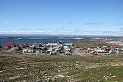
| Resolute | Cornwallis Island | Qikiqtaaluk, NU | 183 |
| Kinngait | Dorset Island | Qikiqtaaluk, NU | 1,396 |
| Grise Fiord | Ellesmere Island | Qikiqtaaluk, NU | 144 |
| Sanikiluaq | Flaherty Island | Qikiqtaaluk, NU | 1,010 |
| Igloolik | Igloolik Island | Qikiqtaaluk, NU | 2,049 |
| Gjoa Haven | King William Island | Kitikmeot, NU | 1,349 |
| Coral Harbour | Southampton Island | Kivalliq, NU | 1,038 |
| Cambridge Bay | Victoria Island | Kitikmeot, NU | 1,760 |
| Ulukhaktok | Victoria Island | Inuvik, NT | 408 |
| Total | 23,073 |
Populated islands
Of the more than 36,000 islands, only 11 are populated. Baffin Island, the largest, also has the largest population of 13,309. The population accounts for 67.37 per cent of the 19,355 people in the Qikiqtaaluk Region, 56.51 per cent of the population of the Arctic Archipelago, and 35.38 per cent of the population of Nunavut.
| Island | Population | Area (km2) | Area (sq mi) | Density (km2) | Density (sq mi) |
|---|---|---|---|---|---|
| Baffin Island | 13,039 | 507,451 | 315,315 | 0.026 | 0.067 |
| Banks Island | 104 | 70,028 | 43,513 | 0.001 | 0.004 |
| Broughton Island | 593 | 127.6 | 79.3 | 4.647 | 12.037 |
| Cornwallis Island | 183 | 6,995 | 4,346 | 0.026 | 0.068 |
| Dorset Island | 1,396 | 21 | 8 | 174.500 | 67.375 |
| Ellesmere Island | 144 | 196,236 | 121,935 | 0.001 | 0.002 |
| Flaherty Island | 1,010 | 1,585 | 985 | 0.637 | 1.650 |
| Igloolik Island | 2,049 | 114.5 | 71.1 | 17.895 | 46.348 |
| King William Island | 1,349 | 13,111 | 8,147 | 0.103 | 0.266 |
| Southampton Island | 1,038 | 41,214 | 25,609 | 0.103 | 0.266 |
| Victoria Island | 2,168 | 217,291 | 135,018 | 0.010 | 0.026 |
Mapping
- ^map 1 King Christian, 77°45′N 102°00′W/77.750°N 102.000°W/ 77.750; -102.000(King Christian Island, NU)
- ^map 2 Borden, 78°33′N 111°10′W/78.550°N 111.167°W/ 78.550; -111.167(Borden Island, NT, NU)
- ^map 3 Lougheed, 77°24′N 105°15′W/77.400°N 105.250°W/ 77.400; -105.250(Lougheed Island, NT)
- ^map 4 Brock, 77°51′N 114°27′W/77.850°N 114.450°W/ 77.850; -114.450(Brock Island, NT)
- ^map 5 Mackenzie King 77°43′N 111°57′W/77.717°N 111.950°W/ 77.717; -111.950(Mackenzie King Island, NT, NU)
- ^map 6 Helena, 76°40′N 101°00′W/76.667°N 101.000°W/ 76.667; -101.000(Helena Island, NU)
- ^map 7 Cameron, 77°48′N 101°51′W/77.800°N 101.850°W/ 77.800; -101.850(Cameron Island, NU)
- ^map 8 Emerald Isle, 76°48′N 114°07′W/76.800°N 114.117°W/ 76.800; -114.117(Emerald Isle, NT)
- ^map 9 Prince Patrick, 76°45′N 119°30′W/76.750°N 119.500°W/ 76.750; -119.500(Prince Patrick Island, NT)
- ^map 10 Île Vanier, 76°10′N 103°15′W/76.167°N 103.250°W/ 76.167; -103.250(Île Vanier, NU)
- ^map 11 Eglinton, 75°46′N 118°27′W/75.767°N 118.450°W/ 75.767; -118.450(Eglinton Island, NT)
- ^map 12 Alexander, 75°52′N 102°37′W/75.867°N 102.617°W/ 75.867; -102.617(Alexander Island, NU)
- ^map 13 Bathurst, 75°46′N 099°47′W/75.767°N 99.783°W/ 75.767; -99.783(Bathurst Island, NU)
- ^map 14 Melville, 75°30′N 111°30′W/75.500°N 111.500°W/ 75.500; -111.500(Melville Island, NT, NU)
- ^map 15 Byam Martin, 75°12′N 104°17′W/75.200°N 104.283°W/ 75.200; -104.283(Byam Martin Island, NU)
- ^map 16 Banks, 73°00′N 121°30′W/73.000°N 121.500°W/ 73.000; -121.500(Banks Island, NU)
- ^map 17 Stefansson, 73°30′N 105°30′W/73.500°N 105.500°W/ 73.500; -105.500(Stefansson Island, NU)
- ^map 18 Russell, 74°00′N 098°25′W/74.000°N 98.417°W/ 74.000; -98.417(Russell Island, NU)
- ^map 19 Prince of Wales, 72°36′N 098°32′W/72.600°N 98.533°W/ 72.600; -98.533(Prince of Wales Island, NU)
- ^map 20 Prescott, 73°03′N 096°49′W/73.050°N 96.817°W/ 73.050; -96.817(Prescott Island, NU)
- ^map 21 Somerset, 73°15′N 093°30′W/73.250°N 93.500°W/ 73.250; -93.500(Somerset Island, NU)
- ^map 22 Victoria, 71°00′N 110°00′W/71.000°N 110.000°W/ 71.000; -110.000(Victoria Island, NT, NU)
- ^map 23 King William, 68°58′N 097°14′W/68.967°N 97.233°W/ 68.967; -97.233(King William Island, NU)
- ^map 24 Matty, 69°28′N 095°40′W/69.467°N 95.667°W/ 69.467; -95.667(Matty Island, NU)
- ^map 25 Wales, 68°01′N 086°40′W/68.017°N 86.667°W/ 68.017; -86.667(Wales Island, NU)
- ^map 26 Belcher, 56°20′N 079°30′W/56.333°N 79.500°W/ 56.333; -79.500(Belcher Islands, NU)
- ^map 27 Long, 54°52′N 079°25′W/54.867°N 79.417°W/ 54.867; -79.417(Long Island, NU)
- ^map 28 Akimiski, 53°00′N 081°20′W/53.000°N 81.333°W/ 53.000; -81.333(Akimiski Island, NU)
- ^map 29 Charlton, 52°00′N 079°26′W/52.000°N 79.433°W/ 52.000; -79.433(Charlton Island, NU)
- ^map 30 Ellesmere, 79°49′N 078°00′W/79.817°N 78.000°W/ 79.817; -78.000(Ellesmere Island, NU)
- ^map 31 Meighen, 79°59′N 099°30′W/79.983°N 99.500°W/ 79.983; -99.500(Meighen Island, NU)
- ^map 32 Axel Heiberg, 79°26′N 090°46′W/79.433°N 90.767°W/ 79.433; -90.767(Axel Heiberg Island, NU)
- ^map 33 Ellef Ringnes, 78°37′N 101°56′W/78.617°N 101.933°W/ 78.617; -101.933(Ellef Ringnes Island, NU)
- ^map 34 Amund Ringnes, 78°19′N 096°25′W/78.317°N 96.417°W/ 78.317; -96.417(Amund Ringnes Island, NU)
- ^map 35 Cornwall, 77°37′N 094°52′W/77.617°N 94.867°W/ 77.617; -94.867(Cornwall Island, NU)
- ^map 36 Graham, 77°26′N 090°30′W/77.433°N 90.500°W/ 77.433; -90.500(Graham Island, NU)
- ^map 37 North Kent, 76°40′N 090°15′W/76.667°N 90.250°W/ 76.667; -90.250(North Kent Island, NU)
- ^map 38 Baillie-Hamilton, 75°53′N 094°35′W/75.883°N 94.583°W/ 75.883; -94.583(Baillie-Hamilton Island, NU)
- ^map 39 Little Cornwallis, 75°30′N 096°30′W/75.500°N 96.500°W/ 75.500; -96.500(Little Cornwallis Island, NU)
- ^map 40 Cornwallis, 75°05′N 095°00′W/75.083°N 95.000°W/ 75.083; -95.000(Cornwallis Island, NU)
- ^map 41 Devon, 75°15′N 088°00′W/75.250°N 88.000°W/ 75.250; -88.000(Devon Island, NU)
- ^map 42 Bylot, 73°13′N 078°34′W/73.217°N 78.567°W/ 73.217; -78.567(Bylot Island, NU)
- ^map 43 Baffin, 69°00′N 072°00′W/69.000°N 72.000°W/ 69.000; -72.000(Baffin Island, NU)
- ^map 44 Jens Munk, 69°40′N 079°40′W/69.667°N 79.667°W/ 69.667; -79.667(Jens Munk Island, NU)
- ^map 45 Koch, 69°35′N 078°20′W/69.583°N 78.333°W/ 69.583; -78.333(Koch Island, NU)
- ^map 46 Bray, 69°20′N 077°00′W/69.333°N 77.000°W/ 69.333; -77.000(Bray Island, NU)
- ^map 47 Rowley, 69°05′N 078°52′W/69.083°N 78.867°W/ 69.083; -78.867(Rowley Island, NU)
- ^map 48 Foley, 68°30′N 075°00′W/68.500°N 75.000°W/ 68.500; -75.000(Foley Island, NU)
- ^map 49 Air Force, 67°58′N 074°05′W/67.967°N 74.083°W/ 67.967; -74.083(Air Force Island, NU)
- ^map 50 Prince Charles, 67°45′N 076°00′W/67.750°N 76.000°W/ 67.750; -76.000(Prince Charles Island, NU)
- ^map 51 Vansittart, 65°50′N 084°00′W/65.833°N 84.000°W/ 65.833; -84.000(Vansittart Island, NU)
- ^map 52 White, 65°46′N 084°53′W/65.767°N 84.883°W/ 65.767; -84.883(White Island, NU)
- ^map 53 Southampton, 64°30′N 084°30′W/64.500°N 84.500°W/ 64.500; -84.500(Southampton Island, NU)
- ^map 54 Resolution, 61°35′N 065°00′W/61.583°N 65.000°W/ 61.583; -65.000(Resolution Island, NU)
- ^map 55 Loks Land, 62°26′N 064°38′W/62.433°N 64.633°W/ 62.433; -64.633(Loks Land Island, NU)
- ^map 56 Akpatok, 60°25′N 068°08′W/60.417°N 68.133°W/ 60.417; -68.133(Akpatok Island, NU)
- ^map 57 Big, 62°43′N 070°43′W/62.717°N 70.717°W/ 62.717; -70.717(Big Island, NU)
- ^map 58 Salisbury, 63°35′N 077°00′W/63.583°N 77.000°W/ 63.583; -77.000(Salisbury Island, NU)
- ^map 59 Nottingham, 63°17′N 077°55′W/63.283°N 77.917°W/ 63.283; -77.917(Nottingham Island, NU)
- ^map 60 Mansel, 62°00′N 079°50′W/62.000°N 79.833°W/ 62.000; -79.833(Mansel Island, NU)
- ^map 61 Coats, 62°35′N 082°45′W/62.583°N 82.750°W/ 62.583; -82.750(Coats Island, NU)
- ^map 62 Beechey, 74°43′N 091°51′W/74.717°N 91.850°W/ 74.717; -91.850(Beechey Island, NU)
- ^map 63 Broughton, 67°34′N 063°54′W/67.567°N 63.900°W/ 67.567; -63.900(Broughton Island, NU)
- ^map 64 Cape Chidley, 60°25′45″N 64°27′50″W/60.42917°N 64.46389°W/ 60.42917; -64.46389(Cape Chidley Islands, NU)
- ^map 65 Dorset, 64°12′N 76°32′W/64.200°N 76.533°W/ 64.200; -76.533(Dorset Island, NU)
- ^map 66 Duke of York, 68°15′N 112°30′W/68.250°N 112.500°W/ 68.250; -112.500(Duke of York Archipelago, NU)
- ^map 67 East Pen, 56°45′N 088°40′W/56.750°N 88.667°W/ 56.750; -88.667(East Pen Island, NU)
- ^map 68 Flaherty, 56°14′N 079°17′W/56.233°N 79.283°W/ 56.233; -79.283(Flaherty Island, NU)
- ^map 69 Haig-Thomas, 78°15′N 094°30′W/78.250°N 94.500°W/ 78.250; -94.500(Haig-Thomas Island, NU)
- ^map 70 Hans, 80°49′N 066°27′W/80.817°N 66.450°W/ 80.817; -66.450(Hans Island, Canada, Denmark)
- ^map 71 Herschel, 69°35′N 139°04′W/69.583°N 139.067°W/ 69.583; -139.067(Herschel Island)
- ^map 72 Igloolik, 69°23′N 081°40′W/69.383°N 81.667°W/ 69.383; -81.667(Igloolik Island, NU)
- ^map 73 Killiniq, 60°22′N 064°37′W/60.367°N 64.617°W/ 60.367; -64.617(Killiniq Island, NU)
- ^map 74 Ottawa, 59°34′N 080°16′W/59.567°N 80.267°W/ 59.567; -80.267(Ottawa Islands, NU)
- ^map 75 Prince Leopold, 74°01′N 090°04′W/74.017°N 90.067°W/ 74.017; -90.067(Prince Leopold Island, NU)
- ^map 76 Jenny Lind, 68°43′N 101°58′W/68.717°N 101.967°W/ 68.717; -101.967(Jenny Lind Island, NU)
- ^map 77 Skraeling, 78°55′N 075°40′W/78.917°N 75.667°W/ 78.917; -75.667(Skraeling Island, NU)
- ^map 78 Trodely, 52°14′N 079°26′W/52.233°N 79.433°W/ 52.233; -79.433(Trodely Island, NU)
- ^map 79 Gateshead, 70°35′N 100°25′W/70.583°N 100.417°W/ 70.583; -100.417(Gateshead Island, NU)
- ^map 80 Weston, 52°32′N 079°35′W/52.533°N 79.583°W/ 52.533; -79.583(Weston Island, NU)