Arizona State Route 80
In-game article clicks load inline without leaving the challenge.
State Route 80 (SR80) is a 120.20-mile (193.44-kilometre) long, roughly arc-shaped highway lying in southeastern Arizona. Starting in downtown Benson, the highway serves as the main route through the towns of St. David, Tombstone, Bisbee and Douglas before terminating at the New Mexico state line, becoming New Mexico State Road 80 (NM80). SR80 also acts as the national southern terminus of US191 near Douglas and provides the only connection between the U.S. Highway and its business route in Douglas.
Both SR80 and NM80 were once part of U.S. Route 80, which traveled through Arizona between San Diego, California and Savannah, Georgia, starting in 1926. The US80 designation was retired from this route in 1989 after being made redundant by Interstate 10. Despite being replaced by the Interstate, this segment of old US 80 was not closely paralleled by or reconstructed into I-10, as the Interstate was constructed further north and instead supplants the shorter former route of SR86 and NM14.
Route description
State Route 80 (SR80) begins at an intersection with I-10 Business (4th Street) in Benson near an Amtrak station. The route heads south until it exits the city limit of Benson, where it turns slightly southeast, parallelling the San Pedro River through the southern extent of the San Pedro Valley. At the intersection with Apache Powder Road, SR80 turns eastward, crossing over the San Pedro River and entering St. David as Patton Street. In St. David, SR80 turns south as Lee Street. South of St. David, SR80 continues to parallel the San Pedro River until the highway steers southeast, where the river continues due south. from Just north of Tombstone, SR80 intersects the eastern terminus of SR82. While SR82 heads west towards Nogales, SR80 continues southeast, before entering Tombstone.

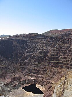
In Tombstone, SR80 becomes Sumner Street, before curving southeast on Fremont Street through town, past the infamous O.K. Corral. Continuing southeast out of Tombstone, SR80 curves south just before passing the Tombstone Municipal Airport. The road intersects the eastern terminus of SR90, which heads west towards Fort Huachuca and Sierra Vista. Past the SR90 junction, SR80 proceeds south through the Mule Mountains, where the highway passes through the Mule Pass Tunnel, entering the Bisbee city limits, then skirts around the southern edge of downtown Bisbee. Downtown Bisbee is accessible from SR80 via two grade-separated interchanges at Tombstone Canyon Road and Main Street. After passing both the inactive Copper Queen Mine and the Lavender Pit, the road meets the eastern terminus of SR92 at a traffic circle. SR92 heads southwest towards Sierra Vista, while SR80 continues east of the traffic circle, past the Warren district of Bisbee. The highway turns southeast at the intersection with Double Adobe Road.

Southeast of Bisbee, SR80 approaches the international boundary with Mexico as it nears Douglas. Immediately west of town, SR80 intersects with the southern terminus of U.S. Route 191, directly north of the old smelter site. Entering town, SR80 becomes 16th Street, which becomes G Avenue shortly before arriving at an intersection with Pan American Avenue, directly in front of the old railroad station, which currently houses the Douglas Police Department. South of this intersection, Pan American Avenue is designated US191 Business, which serves the Raul H. Castro Port of Entry between Douglas and Agua Prieta. As US191 Business does not intersect its parent route, US191, both routes rely on SR80 as a direct connection.
SR80 turns north on Pan American Avenue away from US191 Business. After a short distance, the route takes a more northeasterly route away from the international boundary, paralleling the abandoned trackbed of the El Paso and Southwestern Railroad. SR80 heads through the San Bernardino Valley, passing through the small hamlet of Apache, where the Geronimo Surrender Monument is located. Northeast of Apache, the highway crosses the appropriately named State Line Road at the New Mexico state line and becomes New Mexico State Road 80 (NM80). NM80 continues through Rodeo towards Interstate 10.
History
State Route 80 (SR80) was originally conceived as part of the proposed state highway system in 1919. On November 11, 1926, it became part of the transcontinental highway U.S. Route 80, which ran between San Diego, California and Savannah, Georgia. The road was paved at this time between Douglas and Bisbee as well as a portion south of Tombstone. The remainder of the highway was a gravel road. By 1931, the highway was paved from Bisbee to the New Mexico state line as well as a portion south of Benson and another portion south of Tombstone. By 1934, the only portion of the highway yet to be paved was a section between Tombstone and Bisbee. The entire route had been paved by 1935.
By 1964, most of the US80 nationwide was being largely replaced or made redundant by Interstate 8, Interstate 10 and Interstate 20. On July 1, 1964, California decommissioned its entire segment of US80 between San Diego and Yuma. The state of Arizona followed suit in 1977, decommissioning all of US80 west of I-10 in Benson. This made Benson the western terminus of US80. Between Benson and Rodeo, New Mexico, I-10 did not directly replace US80, as the new interstate was constructed over the heavier traveled and shorter route of former Arizona State Route 86 and New Mexico State Road 14. US80 remained designated east of Benson until 1989, when US80 was truncated to the Texas state line in Anthony, New Mexico, removing the designation entirely from within the state of Arizona. All of former US80 between Fourth Street in Benson and the New Mexico state line was redesignated as SR80. The remainder of former US80 between SR80 and I-10 along Fourth Street is now designated as part of I-10 Business.
On September 21, 2018, most of SR80 was designated as the Benson to New Mexico segment of Historic U.S. Route80. The designation was further applied to parts of Allen Street and 6th Street in Tombstone along with Old Divide Road/Tombstone Canyon Road as well as Main Street in Bisbee and G Avenue, 10th Street and A Avenue in Douglas. These other roads were also designated as part of US80 in previous years, but were bypassed before SR80 was designated. The I-10 Business Loop in Benson was also designated as part of the Historic Route, as the loop between I-10 and SR80 was part of US80 before 1989.
Junction list
The entire route is in Cochise County.
| Location | mi | km | Destinations | Notes |
|---|---|---|---|---|
| Benson | 293.35 | 472.10 | BL10 (4th Street)/ Historic US80 west– Tucson, Willcox | Interchange; western terminus; western end of Historic US80 concurrency |
| | 313.91 | 505.19 | SR82 west– Nogales | |
| 332.88 | 535.72 | SR90 west– Sierra Vista, Fort Huachuca | ||
| 338.74 | 545.15 | Historic US80 east (Old Divide Road) | Eastern end of Historic US80 concurrency | |
| 339.07 | 545.68 | Mule Pass Tunnel | ||
| Bisbee | 339.89 | 547.00 | West Boulevard / Tombstone Canyon Road (Historic US80) | Interchange |
| 341.44 | 549.49 | Old Bisbee (Historic US80 west) | Interchange; western end of Historic US80 concurrency | |
| 343.29 | 552.47 | SR92 west/ Bisbee Road– Sierra Vista | Traffic circle | |
| Douglas | 364.67 | 586.88 | US191 north– Willcox | Southern terminus of US 191 |
| 366.12 | 589.21 | US191 Bus. south (Pan American Avenue south)/ Historic US80 east ("G" Avenue)– Business/Historic District, Mexico | Northern terminus of US191Bus.; eastern end of Historic US80 concurrency | |
| 368.06 | 592.34 | Historic US80 west ("A" Avenue)– Business/Historic District | Western end of Historic US80 concurrency | |
| | 415.39 | 668.51 | Historic US80 ends NM80 north | Continuation into New Mexico; eastern end of Historic US80 concurrency |
| 1.000mi = 1.609km; 1.000km = 0.621mi Concurrency terminus |
See also
- Arizonaportal
- U.S. roadsportal
External links
- Media related toArizona State Route 80at Wikimedia Commons