Gordon/Barrie Island
In-game article clicks load inline without leaving the challenge.
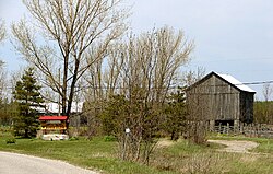
The Municipality of Gordon/Barrie Island is a township in Manitoulin District in north central Ontario, Canada. It was formed on January 1, 2009, upon the amalgamation of the townships of Gordon (incorporated 1875) and Barrie Island.
The township consists of the communities of Advance, Foxey, Ice Lake, Tobacco Lake, and Barrie Island. Gordon/Barrie Island also contains three lakes: Nameless Lake, Tobacco Lake, and Ice Lake.
Barrie Island
Barrie Island (45°55′N 82°40′W/45.917°N 82.667°W/ 45.917; -82.667) is about 8 kilometres (5.0 mi) wide, 13 kilometres (8.1 mi) long, and had a surface area of 78.9 square kilometres (30.5 sq mi) in the 2006 census. It is connected to Manitoulin by Highway 540A, which crosses the water via a causeway at the narrowest part of the strait.
The island, named after Robert Barrie, has a significant summer recreational population.
John Gordon Lane was born on Barrie Island, the Member of Provincial Parliament for Algoma—Manitoulin from 1971 to 1987.
Demographics
In the 2021 Census of Population conducted by Statistics Canada, Gordon/Barrie Island had a population of 613 living in 294 of its 621 total private dwellings, a change of 25.1% from its 2016 population of 490. With a land area of 263.44 km2 (101.71 sq mi), it had a population density of 2.3/km2 (6.0/sq mi) in 2021.
| 2021 | 2016 | 2011 | |
| Population | 613 (+25.1% from 2016) | 490 (-6.8% from 2011) | 526 (+14.6% from 2006) |
| Land area | 263.44 km2 (101.71 sq mi) | 267.77 km2 (103.39 sq mi) | 268.14 km2 (103.53 sq mi) |
| Population density | 2.3/km2 (6.0/sq mi) | 1.8/km2 (4.7/sq mi) | 2.0/km2 (5.2/sq mi) |
| Median age | 61.6 (M: 62.8, F: 60.0) | 51.4 (M: 52.4, F: 50.4) | |
| Private dwellings | 621 (total) 294 (occupied) | 523 (total) | 599 (total) |
| Median household income | $68,500 | $56,960 |
| Year | Pop. | ±% |
|---|---|---|
| Historical census populations – Gordon Township (1875–2008) | ||
| YearPop.±%1881565—1891455−19.5%1901440−3.3%1911429−2.5%1921363−15.4%1931387+6.6%1941375−3.1% | YearPop.±%1951557+48.5%1956507−9.0%1961490−3.4%1966462−5.7%1971352−23.8%1976336−4.5%1981367+9.2% | YearPop.±%1986384+4.6%1991435+13.3%1996473+8.7%2001473+0.0%2006412−12.9% |
| 1881 | 565 | — |
| 1891 | 455 | −19.5% |
| 1901 | 440 | −3.3% |
| 1911 | 429 | −2.5% |
| 1921 | 363 | −15.4% |
| 1931 | 387 | +6.6% |
| 1941 | 375 | −3.1% |
| Year | Pop. | ±% |
| 1951 | 557 | +48.5% |
| 1956 | 507 | −9.0% |
| 1961 | 490 | −3.4% |
| 1966 | 462 | −5.7% |
| 1971 | 352 | −23.8% |
| 1976 | 336 | −4.5% |
| 1981 | 367 | +9.2% |
| Year | Pop. | ±% |
| 1986 | 384 | +4.6% |
| 1991 | 435 | +13.3% |
| 1996 | 473 | +8.7% |
| 2001 | 473 | +0.0% |
| 2006 | 412 | −12.9% |
| Population counts are not adjusted for boundary changes. Source: Statistics Canada |
| Year | Pop. | ±% |
|---|---|---|
| Historical census populations – Barrie Island Township | ||
| YearPop.±%1881143—1891209+46.2%1901268+28.2%1911206−23.1%1921196−4.9%1931164−16.3%1941164+0.0% | YearPop.±%1951159−3.0%1956149−6.3%1961146−2.0%1966118−19.2%1971109−7.6%1976108−0.9%198192−14.8% | YearPop.±%198684−8.7%199175−10.7%199660−20.0%200150−16.7%200647−6.0% |
| 1881 | 143 | — |
| 1891 | 209 | +46.2% |
| 1901 | 268 | +28.2% |
| 1911 | 206 | −23.1% |
| 1921 | 196 | −4.9% |
| 1931 | 164 | −16.3% |
| 1941 | 164 | +0.0% |
| Year | Pop. | ±% |
| 1951 | 159 | −3.0% |
| 1956 | 149 | −6.3% |
| 1961 | 146 | −2.0% |
| 1966 | 118 | −19.2% |
| 1971 | 109 | −7.6% |
| 1976 | 108 | −0.9% |
| 1981 | 92 | −14.8% |
| Year | Pop. | ±% |
| 1986 | 84 | −8.7% |
| 1991 | 75 | −10.7% |
| 1996 | 60 | −20.0% |
| 2001 | 50 | −16.7% |
| 2006 | 47 | −6.0% |
| Source: Statistics Canada |