Calamba–Pagsanjan Road
In-game article clicks load inline without leaving the challenge.
The Calamba–Pagsanjan Road, officially known as Calamba–Sta. Cruz–Famy Junction Road, Manila South Road, and National Highway, is a two-to-four lane primary highway located in the province of Laguna in the Philippines.
The entire road is designated as National Route 66 (N66), a national primary route of the Philippine highway network.
Route description

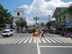
It starts from the intersection of the Old National Highway (Manila South Road) at the Calamba Crossing in Calamba. It then follows a route that circumscribes Laguna de Bay, passing through the municipalities of Los Baños, Bay, Calauan, Victoria, Pila, Santa Cruz, the capital of Laguna, and terminates in Pagsanjan, all in Laguna.
Alternative names
The highway is also known as National Highway or Manila South Road (Extension) for being such. It forms part of the Calamba to Pagsanjan segment of the Calamba–Sta. Cruz–Famy Junction Road. Its section in Calauan and Victoria is also known as Masapang Highway (misspelled or also known as Maspang Highway), apparently after the barangay of the same name in Victoria where its eastern end is located. At the town proper of Pagsanjan, it is locally known as J.P. Rizal Street or simply as Rizal Street.
History
Most of the highway existed back to the American colonial era as part of Highway 21 that linked the city of Manila to the provinces of Rizal and Laguna by circumscribing Laguna de Bay. The Calamba–Calauan segment of the highway was part of the Manila South Road system prior to the completion of the present-day section of the Pan-Philippine Highway from Santo Tomas, Batangas to San Pablo, Laguna during that era. The entire road formed part of what was known as the Calamba–Santa Cruz–Rizal Boundary Road. Roads bypassing the poblacions of Santa Cruz, Calauan, and Bay were later built to form the present-day highway alignment.
As of 2026, the Department of Public Works and Highways (DPWH) revised the western terminus of the Calamba–Pagsanjan Road from its junction with J.P. Rizal Street and Real Road (officially known as Rizal Shrine Road) to its intersection with Manila South Road, both at the Calamba Crossing, incorporating a segment of the latter into its alignment.
Intersections
The entire route is located in Laguna. Intersections are numbered by kilometer posts, with Rizal Park in Manila designated as kilometer zero.
| City/Municipality | km | mi | Destinations | Notes |
|---|---|---|---|---|
| Calamba | 50.9 | 31.6 | N1 (Manila South Road) | Western terminus |
| 51.1 | 31.8 | N420-2 (Real Road / J.P. Rizal Street) | Traffic light intersection. Access to Rizal Shrine and old Calamba City proper. | |
| 55.4 | 34.4 | Milagrosa–Bucal Bypass Road | Traffic light intersection | |
| Los Baños | 61.8 | 38.4 | N420-3 (Jamboree Road) | |
| 64.3 | 40.0 | N420-3 (Lopez Avenue) / Junction Road | ||
| Bay | 67.8 | 42.1 | Bay Poblacion Road | |
| 68.3 | 42.4 | F.T. San Luis Avenue | ||
| 69.4 | 43.1 | Bay–Calauan Road / Bay Poblacion Road | Traffic light intersection | |
| Victoria | 74.9 | 46.5 | N67 (Calauan–Victoria Road) | Itik Park |
| Pila | 80.8 | 50.2 | Rizal Street / Pila-Calumpang Road | |
| 82.2 | 51.1 | General Luna Street (Pila-Poblacion Road) | ||
| Santa Cruz | 86.4 | 53.7 | N602-1 (Quezon Avenue) / Calumpang-Santa Cruz Road | |
| 89.7 | 55.7 | N602-1 (Pedro Guevarra Avenue) | ||
| Pagsanjan | 93.4 | 58.0 | N66 / N603 (Gen. Taiño Street) | Eastern terminus |
| 1.000 mi = 1.609 km; 1.000 km = 0.621 mi |