The municipality was known for its traditional and modern limestone (marble) quarries and related crafts industry. The Atlanterhavsveien coastal road connected Eide Municipality to neighboring Averøy Municipality to the east. The municipal border was located at the Storseisundet Bridge on the Atlanterhavsveien road.
Prior to its dissolution in 2020, the 152-square-kilometre (59 sq mi) municipality was the 353rd largest by area out of the 422 municipalities in Norway. Eide Municipality was the 248th most populous municipality in Norway with a population of about 3,433. The municipality's population density was 22.6 inhabitants per square kilometre (59/sq mi) and its population had increased by 3.5% over the previous 10-year period.
General information
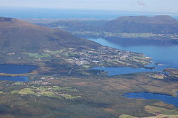
View of the Atlantic Ocean RoadView of the village of EideView of the mountain Stortussen
The municipality of Eide was established on 1 January 1897 when the large Kvernes Municipality was divided into four municipalities: Eide Municipality (population: 1,552) in the west, Kornstad Municipality (population: 1,599) in the center, Bremsnes Municipality (population: 2,917) in the northeast, and Kvernes Municipality (population: 857) in the southeast.
During the 1960s, there were many municipal mergers across Norway due to the work of the Schei Committee. On 1 January 1964, the Vevang area (population: 562) was transferred from Kornstad Municipality to Eide Municipality. On 1 January 1983, the uninhabited island of Eldhusøya (now part of the Atlanterhavsveien road) was transferred from Eide Municipality to Averøy Municipality.
The municipality (originally the parish) is named after the old Eide farm (Old Norse: Eið) since the first Eide Church was built there. The name comes from the dative case of the word eið which means "isthmus". This name is not referring to a true isthmus, but rather referring to a small valley area between two large hills and between the fjord and a large lake where the main village of Eide is located.
Coat of arms
The coat of arms was granted on 9 July 1982. The official blazon is "Azure, three swans argentnaiant wings displayed, 2 over 1" (Norwegian: I blått tre svømmende sølv svaner, to over en). This means the arms have a blue field (background) and the charge is three whooper swans(Cygnus cygnus). The swans have a tincture of argent which means they are commonly colored white, but if the arms are made out of metal, then silver is used. The swans are facing dexter in a swimming position. The swans were chosen since they are very common in the many local lakes. Each swan has seven feathers, representing the seven main villages in the municipality. The arms were designed by Jarle Skuseth. The municipal flag has the same design as the coat of arms.
The municipality was located on the northern part of the Romsdal Peninsula, just west of the island of Averøya. Kvitholmen Lighthouse was located just off the northern coast of the municipality, in an area with hundreds of small islands and skerries. Fræna Municipality was located to the west, Gjemnes Municipality was to the southeast, and Averøy Municipality was to the east. The open Norwegian Sea was to the north. The highest point in the municipality was the 1,026.5-metre (3,368 ft) tall mountain Snøtinden.
The municipal council (Kommunestyre) of Eide Municipality was made up of 21 representatives that were elected to four year terms. The tables below show the historical composition of the council by political party.
The mayor (Norwegian: ordfører) of Eide Municipality was the political leader of the municipality and the chairperson of the municipal council. The following people have held this position: