HS postcode area
In-game article clicks load inline without leaving the challenge.
The HS postcode area, also known as the Outer Hebrides postcode area, is a group of nine postcode districts, within eight post towns, covering the Outer Hebrides in Scotland.
It is the UK's newest postcode area, the Outer Hebrides formerly being part of the PA postcode area (forming PA80 - PA87 until January 1995).
Mail for the HS postcode area is processed at Inverness Mail Centre, along with mail for the IV and KW postcode areas.
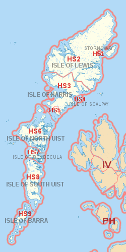
Coverage
The approximate coverage of the postcode districts:
| Postcode district | Post town | Coverage | Local authority area(s) |
|---|---|---|---|
| HS1 | STORNOWAY | Stornoway (immediate area), Plasterfield | Comhairle nan Eilean Siar |
| HS2 | ISLE OF LEWIS | Settlements in Lewis outside the Stornoway area including Back, Carloway, Ness, North Lochs, Park (South Lochs), Point, Uig and West Side | |
| HS3 | ISLE OF HARRIS | Harris excluding Leverburgh and Rodel area | |
| HS4 | ISLE OF SCALPAY | All settlements | |
| HS5 | ISLE OF HARRIS | Leverburgh, Rodel | |
| HS6 | ISLE OF NORTH UIST | All settlements | |
| HS7 | ISLE OF BENBECULA | All settlements | |
| HS8 | ISLE OF SOUTH UIST | All settlements | |
| HS9 | ISLE OF BARRA | All settlements, including Mingulay |
Map