Harvey County, Kansas
In-game article clicks load inline without leaving the challenge.
Harvey County is a county located in the U.S. state of Kansas. Its county seat and most populous city is Newton. As of the 2020 census, the county population was 34,024. The county was named for James Harvey, a U.S. senator and the fifth governor of Kansas.
History
In 1854, the Kansas Territory was organized, then in 1861 Kansas became the 34th U.S. state.
In 1871, the Atchison, Topeka and Santa Fe Railway extended a main line from Emporia to Newton. The next year, in 1872, Harvey County was founded from portions of McPherson, Marion, and Sedgwick counties, and named in honor of the fifth Governor of Kansas, James M. Harvey, with Newton designated the county seat.
The first settlers arrived in 1869, and by 1871, there was already significant pressure to organize a new county in what was then the northern portion of Sedgwick County, an effort which succeeded in 1872. The early years of Harvey County's government were dogged by persistent public discontent over missing records and financial irregularities, but by the mid-1870s confidence in the county's government was restored and the county grew rapidly, particularly with the arrival of large numbers of Mennonite settlers in 1872.
The county developed quickly, with churches, schools, and businesses established within a few years of its founding. Despite early hardship from prairie fires, storms, and the devastating grasshopper plague of 1874, Harvey County rebounded with strong agricultural output and infrastructure improvements. The county's abundant water resources, fertile farmland, and natural materials like gypsum and limestone further strengthened its economy. By 1910, Harvey County had a population of 19,200 and no public debt, a rare achievement among Kansas counties at that time.
Geography
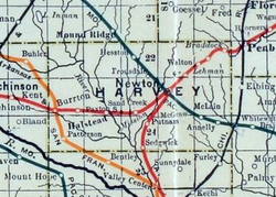
According to the U.S. Census Bureau, the county has a total area of 541 square miles (1,400 km2), of which 540 square miles (1,400 km2) is land and 1.0 square mile (2.6 km2) (0.2%) is water. The Little Arkansas River flows through the county.
Adjacent counties
- Marion County (northeast)
- Butler County (east)
- Sedgwick County (south)
- Reno County (west)
- McPherson County (northwest)
Demographics
| Census | Pop. | Note | %± |
|---|---|---|---|
| 1880 | 11,451 | — | |
| 1890 | 17,601 | 53.7% | |
| 1900 | 17,591 | −0.1% | |
| 1910 | 19,200 | 9.1% | |
| 1920 | 20,744 | 8.0% | |
| 1930 | 22,120 | 6.6% | |
| 1940 | 21,712 | −1.8% | |
| 1950 | 21,698 | −0.1% | |
| 1960 | 25,865 | 19.2% | |
| 1970 | 27,236 | 5.3% | |
| 1980 | 30,531 | 12.1% | |
| 1990 | 31,028 | 1.6% | |
| 2000 | 32,869 | 5.9% | |
| 2010 | 34,684 | 5.5% | |
| 2020 | 34,024 | −1.9% | |
| 2025 (est.) | 33,580 | −1.3% | |
| U.S. Decennial Census 1790-1960 1900-1990 1990-2000 2010-2020 |
Harvey County is part of the Wichita metropolitan area.
2020 census
As of the 2020 census, the county had a population of 34,024. The median age was 40.7 years. 23.8% of residents were under the age of 18 and 20.9% of residents were 65 years of age or older.
For every 100 females there were 96.4 males, and for every 100 females age 18 and over there were 94.3 males age 18 and over. 59.9% of residents lived in urban areas, while 40.1% lived in rural areas.
The racial makeup of the county was 84.2% White, 1.9% Black or African American, 0.8% American Indian and Alaska Native, 0.8% Asian, 0.0% Native Hawaiian and Pacific Islander, 4.4% from some other race, and 7.9% from two or more races. Hispanic or Latino residents of any race comprised 11.9% of the population.
There were 13,363 households in the county, of which 30.0% had children under the age of 18 living with them and 24.0% had a female householder with no spouse or partner present. About 28.0% of all households were made up of individuals and 13.5% had someone living alone who was 65 years of age or older.
There were 14,569 housing units, of which 8.3% were vacant. Among occupied housing units, 69.6% were owner-occupied and 30.4% were renter-occupied. The homeowner vacancy rate was 2.0% and the rental vacancy rate was 10.2%.
2000 census
As of the 2000 census, there were 32,869 people, 12,581 households, and 8,932 families residing in the county. The population density was 61 inhabitants per square mile (24/km2). There were 13,378 housing units at an average density of 25 per square mile (9.7/km2). The racial makeup of the county was 91.04% White, 1.59% Black or African American, 0.52% Native American, 0.52% Asian, 0.03% Pacific Islander, 4.17% from other races, and 2.14% from two or more races. Hispanic or Latino of any race were 7.97% of the population.
There were 12,581 households, out of which 32.80% had children under the age of 18 living with them, 60.20% were married couples living together, 7.70% had a female householder with no husband present, and 29.00% were non-families. 25.80% of all households were made up of individuals, and 11.60% had someone living alone who was 65 years of age or older. The average household size was 2.50 and the average family size was 3.00.
In the county, the population was spread out, with 26.00% under the age of 18, 9.10% from 18 to 24, 26.50% from 25 to 44, 21.60% from 45 to 64, and 16.80% who were 65 years of age or older. The median age was 38 years. For every 100 females, there were 94.50 males. For every 100 females age 18 and over, there were 91.60 males.
The median income for a household in the county was $40,907, and the median income for a family was $48,793. Males had a median income of $35,037 versus $22,492 for females. The per capita income for the county was $18,715. About 4.20% of families and 6.40% of the population were below the poverty line, including 7.50% of those under age 18 and 5.00% of those age 65 or over.
Government
Presidential elections
| Year | Republican | Democratic | Third party(ies) | |||
|---|---|---|---|---|---|---|
| No. | % | No. | % | No. | % | |
| 1888 | 2,145 | 54.25% | 1,065 | 26.93% | 744 | 18.82% |
| 1892 | 2,025 | 52.80% | 0 | 0.00% | 1,810 | 47.20% |
| 1896 | 2,082 | 54.57% | 1,678 | 43.98% | 55 | 1.44% |
| 1900 | 2,266 | 56.65% | 1,658 | 41.45% | 76 | 1.90% |
| 1904 | 2,362 | 70.66% | 690 | 20.64% | 291 | 8.70% |
| 1908 | 2,305 | 58.30% | 1,475 | 37.30% | 174 | 4.40% |
| 1912 | 703 | 17.70% | 1,499 | 37.74% | 1,770 | 44.56% |
| 1916 | 3,479 | 48.98% | 3,131 | 44.08% | 493 | 6.94% |
| 1920 | 4,454 | 63.09% | 2,457 | 34.80% | 149 | 2.11% |
| 1924 | 4,499 | 58.96% | 1,744 | 22.86% | 1,387 | 18.18% |
| 1928 | 6,330 | 77.62% | 1,748 | 21.43% | 77 | 0.94% |
| 1932 | 4,192 | 49.28% | 4,091 | 48.09% | 224 | 2.63% |
| 1936 | 4,456 | 45.28% | 5,357 | 54.44% | 28 | 0.28% |
| 1940 | 5,539 | 56.76% | 4,087 | 41.88% | 133 | 1.36% |
| 1944 | 5,339 | 61.35% | 3,300 | 37.92% | 64 | 0.74% |
| 1948 | 5,270 | 57.72% | 3,615 | 39.59% | 245 | 2.68% |
| 1952 | 7,154 | 70.87% | 2,726 | 27.00% | 215 | 2.13% |
| 1956 | 7,367 | 70.20% | 3,084 | 29.39% | 43 | 0.41% |
| 1960 | 7,798 | 68.38% | 3,537 | 31.02% | 69 | 0.61% |
| 1964 | 4,979 | 47.81% | 5,306 | 50.95% | 130 | 1.25% |
| 1968 | 6,682 | 61.64% | 3,351 | 30.91% | 808 | 7.45% |
| 1972 | 8,287 | 67.23% | 3,555 | 28.84% | 485 | 3.93% |
| 1976 | 6,624 | 51.00% | 6,003 | 46.22% | 360 | 2.77% |
| 1980 | 7,045 | 54.56% | 4,173 | 32.32% | 1,694 | 13.12% |
| 1984 | 8,507 | 64.06% | 4,599 | 34.63% | 174 | 1.31% |
| 1988 | 6,893 | 54.23% | 5,503 | 43.29% | 315 | 2.48% |
| 1992 | 6,259 | 41.71% | 5,047 | 33.63% | 3,700 | 24.66% |
| 1996 | 8,382 | 57.79% | 4,918 | 33.91% | 1,204 | 8.30% |
| 2000 | 8,271 | 60.44% | 4,591 | 33.55% | 822 | 6.01% |
| 2004 | 9,534 | 63.10% | 5,331 | 35.28% | 245 | 1.62% |
| 2008 | 9,006 | 57.40% | 6,318 | 40.27% | 367 | 2.34% |
| 2012 | 8,588 | 60.08% | 5,373 | 37.59% | 333 | 2.33% |
| 2016 | 8,668 | 57.34% | 5,068 | 33.53% | 1,380 | 9.13% |
| 2020 | 10,182 | 58.52% | 6,747 | 38.78% | 470 | 2.70% |
| 2024 | 9,591 | 59.62% | 6,202 | 38.56% | 293 | 1.82% |
Laws
Following amendment to the Kansas Constitution in 1986, the county remained a prohibition, or "dry", county until 1996, when voters approved the sale of alcoholic liquor by the individual drink with a 30% food sales requirement.
The county voted "No" on the 2022 Kansas abortion referendum, an anti-abortion ballot measure, by 53% to 47% despite backing Donald Trump with 59% of the vote to Joe Biden's 39% in the 2020 presidential election.
Education
Colleges
Unified school districts
School district office in neighboring county
Communities

List of townships / incorporated cities / unincorporated communities / extinct former communities within Harvey County.
Cities
‡ means a community has portions in an adjacent county.
Unincorporated communities
Ghost towns
- Annelly
- Van Arsdale
Townships
Harvey County is divided into fifteen townships. The cities of Halstead and Newton are considered governmentally independent and are excluded from the census figures for the townships. In the following table, the population center is the largest city (or cities) included in that township's population total, if it is of a significant size.
| Township | FIPS | Population center | Population | Population density /km2 (/sq mi) | Land area km2 (sq mi) | Water area km2 (sq mi) | Water % | Geographic coordinates |
|---|---|---|---|---|---|---|---|---|
| Alta | 01500 | 221 | 2 (6) | 93 (36) | 0 (0) | 0.48% | 38°7′27″N 97°38′44″W/38.12417°N 97.64556°W/ 38.12417; -97.64556 | |
| Burrton | 09600 | 1,143 | 12 (32) | 93 (36) | 0 (0) | 0.17% | 38°1′32″N 97°39′55″W/38.02556°N 97.66528°W/ 38.02556; -97.66528 | |
| Darlington | 17025 | 601 | 7 (17) | 92 (35) | 0 (0) | 0.10% | 37°57′5″N 97°19′32″W/37.95139°N 97.32556°W/ 37.95139; -97.32556 | |
| Emma | 21025 | 4,181 | 45 (116) | 93 (36) | 0 (0) | 0% | 38°8′10″N 97°25′46″W/38.13611°N 97.42944°W/ 38.13611; -97.42944 | |
| Garden | 25300 | 294 | 3 (8) | 93 (36) | 0 (0) | 0% | 38°7′44″N 97°32′14″W/38.12889°N 97.53722°W/ 38.12889; -97.53722 | |
| Halstead | 29625 | 353 | 4 (10) | 92 (35) | 0 (0) | 0.07% | 38°2′9″N 97°31′51″W/38.03583°N 97.53083°W/ 38.03583; -97.53083 | |
| Highland | 31875 | 415 | 5 (12) | 92 (35) | 0 (0) | 0.19% | 38°7′38″N 97°19′9″W/38.12722°N 97.31917°W/ 38.12722; -97.31917 | |
| Lake | 37825 | 173 | 2 (5) | 92 (36) | 1 (0) | 1.05% | 37°57′46″N 97°39′7″W/37.96278°N 97.65194°W/ 37.96278; -97.65194 | |
| Lakin | 38150 | 357 | 4 (10) | 92 (35) | 0 (0) | 0.06% | 37°57′18″N 97°32′20″W/37.95500°N 97.53889°W/ 37.95500; -97.53889 | |
| Macon | 43925 | 1,056 | 11 (30) | 92 (36) | 0 (0) | 0% | 38°2′8″N 97°24′58″W/38.03556°N 97.41611°W/ 38.03556; -97.41611 | |
| Newton | 50500 | 1,950 | 28 (73) | 69 (27) | 0 (0) | 0.07% | 38°3′27″N 97°19′31″W/38.05750°N 97.32528°W/ 38.05750; -97.32528 | |
| Pleasant | 56250 | 439 | 5 (12) | 93 (36) | 1 (0) | 0.81% | 38°2′27″N 97°12′8″W/38.04083°N 97.20222°W/ 38.04083; -97.20222 | |
| Richland | 59350 | 360 | 4 (10) | 94 (36) | 0 (0) | 0.20% | 37°57′39″N 97°12′1″W/37.96083°N 97.20028°W/ 37.96083; -97.20028 | |
| Sedgwick | 63825 | 1,711 | 18 (48) | 93 (36) | 0 (0) | 0% | 37°56′24″N 97°25′22″W/37.94000°N 97.42278°W/ 37.94000; -97.42278 | |
| Walton | 75225 | 552 | 6 (15) | 95 (37) | 0 (0) | 0.06% | 38°7′26″N 97°13′1″W/38.12389°N 97.21694°W/ 38.12389; -97.21694 | |
| Sources: . U.S. Census Bureau, Geography Division. Archived from on August 2, 2002. |
See also
- National Register of Historic Places listings in Harvey County, Kansas
- List of people from Harvey County, Kansas
- March 1990 Central US tornado outbreak
- Chisholm Trail
Community information for Kansas
- Kansas locations by per capita income
- List of counties in Kansas
- List of townships in Kansas
- List of cities in Kansas
- List of unincorporated communities in Kansas
- List of ghost towns in Kansas
Notes
Further reading
County
- ; Automobile Club of Wichita; 92 pages; 1909 to 1910. Contains detailed maps of roads and railroads in City of Wichita, and Sedgwick / Harvey / Sumner / Harper / Rice / Pawnee Counties.
- ; Grant Mitchell; 15 pages; 1926.
- ; Geo. A. Ogle & Co; 70 pages; 1918.
- ; North West Publishing Co; 34 pages; 1902.
- ; 33 pages; John P. Edwards; 1882.
Newton
- [permanent dead link]; David A. Haury; Mennonite Life; December 1974.
External links
County
Historical
Maps
- Harvey County Maps: May 13, 2021, at the Wayback Machine, July 2, 2014, at the Wayback Machine, KDOT
- Kansas Highway Maps: May 7, 2016, at the Wayback Machine, December 19, 2010, at the Wayback Machine, KDOT
- Kansas Railroad Maps: May 7, 2016, at the Wayback Machine, , , KDOT and Kansas Historical Society