Heard Island and McDonald Islands
In-game article clicks load inline without leaving the challenge.
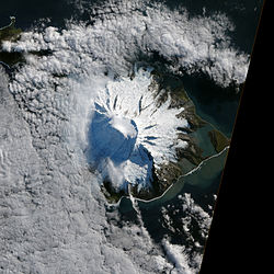
Heard Island and McDonald Islands is an Australian external territory and World Heritage Site in the southern Indian Ocean. Discovered in the mid-19th century, the territory is composed of a group of sub-Antarctic volcanic islands that lie on the Kerguelen Plateau. It is located about 4000 kilometres (2500 mi) south-west of the Australian mainland and 1700 kilometres (1100 mi) north of Antarctica. The territory contains Australia's only active volcanoes and is home to its highest point outside of the Australian Antarctic Territory, Mawson Peak. The islands have been described as one of the most remote places on Earth.
The first confirmed sightings of Heard Island and the McDonald Islands took place in 1853 and 1854 respectively. Heard Island was occupied by sealers between 1855 and 1882 and saw occasional scientific visits in the late-19th and early-20th centuries. The territory was claimed by the United Kingdom in 1908 and was transferred to Australia in 1947. Between 1947 and 1955, the Australian National Antarctic Research Expeditions occupied a research station on the island. Since the closure of the ANARE research station in 1955, the islands have been visited by occasional scientific and private expeditions. Today, the islands are a nature reserve managed by the Australian Antarctic Division.
Heard Island is dominated by Big Ben, a stratovolcano that is topped by the volcanic cone Mawson Peak. About 70 percent of the island is permanently covered by glaciers, while just 5 percent is covered by vegetation. The island is volcanically active, with Mawson Peak regularly emitting steam and vapour and occasionally releasing flows of lava. The McDonald Islands group, located about 43 kilometres (27 mi) to the west of Heard Island, is a smaller group of volcanic islands that has seen just two recorded human landings. Heard Island and the McDonald Islands are known for their harsh climate and conditions, characterised by cold temperatures, strong winds, and heavy rain and snow.
Heard Island and McDonald Islands is home to a large number of eastern rockhopper, gentoo, macaroni, and king penguins. With more than one million breeding pairs, the colony of macaroni penguins on Heard Island is the world's largest. The islands also contain substantial populations of elephant seals and Antarctic fur seals. They are a breeding site for at least 15 flying seabird species, including the Heard Island cormorant. Commercial fishing of Patagonian toothfish and mackerel icefish takes place in the surrounding waters. Due to climate change, Heard Island has seen rapid glacier retreat and other environmental changes in recent decades.
History

The first confirmed sighting of Heard Island took place in 1853 when the island was sighted by Captain John Heard aboard the ship Oriental. Other sailors had reported observing land south of the Kerguelen Islands during the 1830s and 1840s, but it is unclear whether they in fact sighted Heard Island. Heard claimed the island for the United States, but its government declined to endorse the claim. In 1854 Captain William McDonald sighted the McDonald Islands aboard the ship Samarang. A party of sealers led by Captain Erasmus Darwin Rogers of the ship Corinthian made the first recorded landing on Heard Island in 1855.
The island was occupied by sealers between 1855 and 1882, with more than 40 vessels collectively making over 100 visits to hunt elephant seals and process their blubber into oil. Between 1855 and 1880 more than 100,000 barrels of oil were produced on the island. At the peak of production in 1859, there were 24 vessels stationed at Heard Island. The majority of the sealing companies were American and were based out of ports in New England, although some of the sealers were from Cape Verde. During this period 14 ships were wrecked in the waters surrounding the island. According to one estimate, 30 sealers died on Heard Island between 1857 and 1881 and 30 died on their way to the island, largely after being washed overboard. By the 1880s the elephant seal population on the island had been severely depleted, and sealing activity declined substantially.

Brief scientific expeditions to Heard Island took place in 1874, 1902, and 1929, with their observations limited to its north-western side. The ships Challenger and Gauss visited in 1874 and 1902 respectively, each remaining on Heard Island for just a few hours. Two scientific parties landed on the island in 1929 and remained there for eight days: one was led by the Swiss geologist Edgar Aubert de la Rue, while the other was composed of members of the British Australian and New Zealand Antarctic Research Expedition party. Some sealing activity resumed on the island between 1907 and 1930 and occasional visits were made by whaling ships.
Heard Island and the McDonald Islands were claimed by the United Kingdom in 1908. The British flag was raised on Heard Island in 1910 and 1929, and between 1910 and 1926 the British government issued licences for sealing and whaling on the island. A British company was allowed to lease the islands in 1926, but by 1930 it was no longer exercising its lease. After Britain's transfer of the Australian Antarctic Territory to Australia in 1933, the Australian government began preparing to take possession of Heard Island and the McDonald Islands.
In 1947 the Australian National Antarctic Research Expeditions (ANARE) established a research station on Heard Island with a party of 14 men. The party landed at Atlas Cove on a Royal Australian Navy ship on 11 December 1947. They raised the Australian flag and conducted weather observations, geological and wildlife surveys, and mapping of the island over the next 14 months. The station was occupied until 1955 by a rotating series of seven ANARE parties, each of which spent 12–14 months on the island. On 19 December 1950 the territory was transferred from Britain to Australia via an exchange of notes, with the transfer backdated to December 1947. The Australian government subsequently passed the Heard Island and McDonald Islands Act 1953 to establish a mechanism for the administration of its newly acquired territory.
Beginning in 1950 the ANARE parties on Heard Island bred and trained dogs, many of which eventually supported Australian stations on the Antarctic continent. They also operated a radio outpost and weather monitoring station, and conducted a variety of research activities. On 26 May 1952, two members of the ANARE party were killed during an expedition after one was swept away by the waves and another froze to death during a storm. The ANARE station, which eventually grew to about 25 buildings, was closed in 1955 in order to fund the establishment of Mawson Station on the Antarctic continent. Much of the equipment on Heard Island was also transferred to Mawson Station.

Nineteen short research expeditions to the island took place between 1956 and 2004. In 1992, one of these expedition parties remained on the island over the winter for the first time since the closure of the ANARE station in 1955. Infrequent visits by tourists and private expeditions have also taken place since 1963. The island was the site of the 1991 Heard Island feasibility test, which tested whether transmission of acoustic signals through the ocean could be used to study changes in ocean temperatures. The islands were inscribed on the World Heritage List in 1997, and in the same year the Australian ship Austral Leader began commercial fishing of icefish in the waters surrounding the islands. The Heard Island and McDonald Islands Marine Reserve was established in 2002 and was the world's largest marine protected area at the time. In October 2025 and January 2026 the Australian Antarctic Division conducted voyages to Heard Island, marking the first environmental management visits to the island in more than two decades.
Governance and administration
Heard Island and McDonald Islands is one of seven Australian external territories. The islands and the surrounding waters are a strict nature reserve managed by the Australian Antarctic Division, part of the Department of Climate Change, Energy, the Environment and Water. Unauthorised entry to the territory has been prohibited since May 2014, and all visitors to the islands are required to complete a training program and comply with quarantine procedures. Despite these restrictions, some unauthorised landings on the islands are known to have taken place. The Heard Island and McDonald Islands Marine Reserve was established in October 2002 and was expanded in 2014 and 2025. The marine reserve now covers an area of about 381,000 square kilometres (147,000 sq mi) and sits within the 410,722-square-kilometre (158,581 sq mi) Australian exclusive economic zone generated by the islands.
The Australian parliament passed the Heard Island and McDonald Islands Act in 1953 to establish a legal framework for the administration of the territory. This was followed by the 1987 Heard Island and McDonald Islands Environment Protection and Management Ordinance, and then by the first Heard Island Wilderness Reserve Management Plan in 1995. Heard Island and McDonald Islands is governed by the non-criminal laws of the Australian Capital Territory and by the criminal laws of the Jervis Bay Territory. Commonwealth laws apply to the territory only if Heard Island and McDonald Islands is explicitly included within their jurisdiction. The Governor-General of Australia is also able to issue ordinances for the administration of Heard Island and McDonald Islands under the Heard Island and McDonald Islands Act 1953. The Environmental Protection and Biodiversity Conservation Act 1999 acts as the main legislative framework for the environmental conservation of the territory.
While fishing is prohibited within the waters nearest to the islands, commercial fishing takes place elsewhere within the surrounding exclusive economic zone. The Heard Island and McDonald Islands Fishery is managed by the Australian Fisheries Management Authority (AFMA), which sets quotas on fishing catches and monitors compliance with the Convention on the Conservation of Antarctic Marine Living Resources. The species targeted are the Patagonian toothfish and the mackerel icefish. There are about 1–3 vessels harvesting Patagonian toothfish, primarily using longlines, and about 2–5 vessels harvesting mackerel icefish, largely through trawl fishing. Two AFMA observers are required to be present on each vessel. Bycatch of protected species has been identified as a potential threat to the sustainability of the Heard Island and McDonald Islands Fishery.
Illegal fishing has historically been reported in the waters surrounding the islands, particularly by fishers targeting the valuable Patagonian toothfish. In October 1997 a vessel was arrested for unlicensed fishing within the Heard and McDonald Islands Australian Fishing Zone for the first time. That year, it was estimated that up to 70 vessels may have been operating illegally in the region. By 2004 eight vessels had been arrested in the waters surrounding the islands, with seven of those arrests involving the Australian Defence Force. Australian vessels, including those of the Australian Defence Force, have conducted patrols in the waters surrounding the islands to deter and respond to illegal fishing. Since 2003 Australia has had a treaty with France to allow for cooperation in surveilling and patrolling the waters around the islands, as well as the nearby Kerguelen Islands. Since the mid-2000s, illegal fishing has reportedly been eliminated from the waters surrounding the Heard and McDonald Islands; as of 2019 there had been no reports of illegal fishing since 2006–2007.
Structures and archaeology

The first known man-made structures on Heard Island were rudimentary shelters dug into the ground by sealers in the 1850s. By the 1860s, sealers had begun to build above-ground shelters out of rocks, the remains of which remain on the island. A wooden hut may also have been constructed on the island by a shipwrecked party in the late-19th century. Some sealers constructed rudimentary stone platforms on which to work, while others modified lava caves to use as shelters.
One of the first conventional structures erected on Heard Island was Admiralty Hut, built in 1928 by the crew of the whaling ship Kildalkey under commission by the British Admiralty. The hut has been degraded by weather over time and is now in ruins. The remains of the research station occupied by ANARE expedition parties between 1947 and 1955 have largely been cleared from the site by the Australian Antarctic Division, with only the ruins of the recreation hut still standing. More recent expeditions have used temporary fiberglass shelters that were removed after use, as well as modified water tanks. Five of these water tanks remain at Spit Bay, while two are present at Atlas Cove.
The island contains various pieces of machinery and equipment that have been left by past research expeditions, including the wreckage of a landing craft, a bulldozer, diesel generators, fuel barrels, and water tanks. The shores of the island feature wooden debris left by the wreckages of sealing vessels. There are also various artefacts on the island left by sealers, including try pots (large pots used for processing blubber into seal oil) and barrels. Some of these sealing artefacts, including a blubber press, have been removed from the island and taken to museums in Australia.
Geography and climate
Location and geography

Heard Island and McDonald Islands is located in the southern Indian Ocean, about 4100 kilometres (2500 mi) south-west of Perth and 1700 kilometres (1100 mi) north of Antarctica. The closest land is the Kerguelen Islands, a French external territory, which is located about 450 kilometres (280 mi) to the north-west. The islands lie on the Kerguelen Plateau, a large igneous province that covers an area of about 2,000,000 square kilometres (770,000 sq mi). The territory includes Heard Island, Shag Islet, and the McDonald Islands. The islands have been described as one of the most remote places on Earth and contain the only active volcanoes in Australian territory.
Heard Island has an area of around 368 square kilometres (142 sq mi) and is largely made up of a 2745-metre (9006 ft) stratovolcano named Big Ben. With the exception of mountains in the Australian Antarctic Territory, its summit Mawson Peak is the tallest peak on territory claimed by Australia. The island contains a second volcanic cone with a height of 706 metres (2316 ft) named Mount Dixon on the Laurens Peninsula on the western side of the island. The island has a width of about 40 kilometres (25 mi) from east to west and is largely covered by glaciers, with about 70 percent of its land area permanently glaciated. It contains 15 wetland areas with areas of 5–145 hectares (12–358 acres), as well as a number of lagoons formed by glacial melting. These wetlands and lagoons have a total area of about 1860 hectares (4600 acres). Various volcanic features, including lava tube caves and cinder cones, are present on the island.
The McDonald Islands are a smaller group of volcanic islands located about 43 kilometres (27 mi) to the west of Heard Island. After a period of dormancy of around 75,000 years, volcanic activity resumed on the islands during the 20th century. During the 1990s, this volcanic activity caused the islands to grow and rise in elevation by nearly 100 metres (330 ft), with the main island more than doubling in size and losing all of its vegetation. Between 1994 and 2004, McDonald Island grew from about 1 square kilometre (0.39 sq mi) to 2.5 square kilometres (0.97 sq mi) and became joined to the nearby Flat Island by an isthmus. The island has a maximum elevation of about 230 metres (750 ft) and has no permanent ice cover. It is surrounded by cliffs with heights of up to 230 metres (750 ft). There have been just two recorded successful human landings on the McDonald Islands, which took place in 1971 and 1980.
Formation and geology

Heard Island and the McDonald Islands lie on the Kerguelen Plateau, a large igneous province rising up to 3 kilometres (1.9 mi) above the surrounding ocean floor that began forming about 130 million years ago. Volcanic activity on the plateau has created various islands protruding above the ocean surface over time, including Heard Island and the McDonald Islands. A 2016 study estimated that Heard Island began to develop about 22 million years ago during the early Miocene period. The volcanic activity that formed Big Ben is believed to have occurred over the last 1 million years, while Mawson Peak, Mount Dixon, and the lava cones on the island formed as recently as the last 10,000 years. The McDonald Islands are also volcanic in origin and are believed to have formed within roughly the last 100,000 years.
Heard Island's basement is made up of white and pink limestone that was likely deposited about 45–50 million years ago during the Paleogene period. This limestone remains visible on parts of the Laurens Peninsula. On top of the limestone basement sits the Drygalski Formation, a layer of volcanic rock and sediment about 300–350 metres (980–1150 ft) in thickness that formed around 9 million years ago. The Drygalski Formation forms a plateau with exposed layers of rock along the island's northern coast. Volcanic activity on the island over the last million years has created another layer of volcanic material, which forms Big Ben and Mount Dixon.
Features
Big Ben

Big Ben is a volcanic massif that forms the majority of the landscape of Heard Island. It has a plateau at a height of about 2285 metres (7497 ft) which is topped by an active volcanic cone named Mawson Peak. The plateau is believed to be the result of a sector collapse that occurred some time in roughly the last 40,000 years. The volcano has a diameter of about 18–20 kilometres (11–12 mi) and a height of 2745 metres (9006 ft). Compounds of basanite, basalt, and trachybasalt make up the majority of its exposed lavas. A 2021 study estimated that the age of two samples of lava taken from the volcano sat at around 11,100 and 23,900 years. The volcano has a relatively low average discharge rate of about 200,000 cubic metres of magma per year.
Only three parties have successfully reached the summit of Big Ben. The first ascent was made by the Southern Indian Ocean Expedition in 1965, the second by the Anaconda expedition in 1983, and the third by the Australian Army Alpine Association in 1999–2000. The volcano frequently emits smoke and vapour and occasionally releases lava, typically down its south-western slopes. Flows of lava with lengths of 250–2000 metres (820–6560 ft) have occurred roughly once per year since 2008. The volcanic activity on Big Ben is primarily effusive, characterised by flows of lava, rather than explosive. Its peak has featured a crater of varying size and location over time; between 2000 and 2015 Mawson Peak was topped by an open crater containing a lava lake with a diameter of 45–200 metres (148–656 ft). More recent observations have suggested that the crater may have been replaced by a fissure.
Glaciers

Heard Island has 12 major glaciers, which radiate outwards from the summit of Big Ben and are sometimes divided by walls of volcanic rock. A 2025 glacier mapping study identified around 30 glaciers in total. As of 1999, the longest of these glaciers had a length of 7 kilometres (4.3 mi). Parts of the island's coast are made up of ice cliffs with heights of up to 30 metres (98 ft). Most of the glaciers flowing from the summit of Big Ben have a slope of more than 30° near its peak, reducing to around 5° on its lower slopes. Due to Big Ben's steep slopes and the high levels of snowfall on Heard Island, its glaciers are fast-flowing and have a short residence time of about 100 years. The glaciers' shallowness and fast movement mean that they are particularly vulnerable to changes in climate.
Many glaciers on Heard Island have retreated by more than 1 kilometre (0.62 mi) since 1949, leaving substantial lagoons and lakes at their bases. One of the largest glaciers on Heard Island, Stephenson Glacier, ended in 15-metre (49 ft) ice cliffs in 1954, but by 1963 terminated 100 metres (330 ft) from the ocean behind a land barrier and lagoon. Its base now features a growing body of water named the Stephenson Lagoon. Another of the island's glaciers, Brown Glacier, lost 38 percent of its volume and 29 percent of its area and retreated by 1.17 kilometres (0.73 mi) between about 1950 and 2004. A 2025 study estimated that the annual rate of glacier loss had increased from 0.25 percent between 1947 and 1988 to 0.43 percent between 1988 and 2019. Total glacier area declined from an estimated 289.4 square kilometres (111.7 sq mi) in 1947 to 225.7 square kilometres (87.1 sq mi) in 2019, with smaller glaciers in low-lying areas near Laurens Peninsula the most affected.
Climate

Heard Island and McDonald Islands has an antarctic climate. It experiences strong westerly winds, high precipitation, and heavy cloud cover. Average daily temperatures at Atlas Cove on Heard Island are between −0.8 °C (30.6 °F) and 0.3 °C (32.5 °F) in winter, and between 3.7 °C (38.7 °F) and 5.2 °C (41.4 °F) in summer. Monthly wind speeds range from 26 kilometres per hour (16 mph) to 33.5 kilometres per hour (20.8 mph) on average, with maximum daily gusts of up to 180 kilometres per hour (110 mph). The islands experience high snowfall and rainfall, with an average annual precipitation equivalent to 1.3–1.9 metres (4.3–6.2 ft) of water. Between 1948 and 1950 there was an average of just 1.7 hours per day of sunshine, ranging from 0.8 hours per day in June to 2.4 hours per day in November. Rain or snow was recorded on an average of 300 days each year. The territory has consistently high humidity, with relative humidity of about 85 percent.
While meteorological data for the island is incomplete, the average annual temperature on Heard Island is estimated to have increased by about 1 °C between the periods 1948–1954 and 1997–2001. Climate change is believed to be one of the main drivers of glacier retreat on the island, although volcanic activity may also be a contributing factor. Climate change has also led to significant changes in the island's vegetation due to the creation of new ice-free land, lagoons, and lakes. A 2021 study projected that climate change would cause the population of penguins, flying birds, and seals on the island to decline. The population of toothfish in the waters surrounding the islands was projected to fall by 20–60 percent, while the population of mackerel icefish was projected to fall by 20 percent.
Biodiversity

Due to the territory's remoteness, scientific surveys of the Heard and McDonald Islands are infrequent and there is limited recent data on the islands' biodiversity. About 300 species have been recorded on Heard Island, although it is likely that there are others present that have not yet been observed. The Heard and McDonald Islands are the only sub-Antarctic islands that are not home to any species known to have been introduced directly by humans. Various non-native species have been present on Heard Island in the past, including dogs, sheep, and a rat, but none have established a presence on the island. Due to their harsh climate and conditions, the islands have relatively low species diversity.
Flora


The majority of the flora species on Heard Island are non-flowering plants, including bryophytes (a division of plants that includes liverworts and mosses) and lichens. At least 62 species of bryophyte and 90 species of lichen have been recorded on the island. There are just 12 species of vascular plant on Heard Island, of which 5 have also been recorded on McDonald Island. About 20 square kilometres (7.7 sq mi) or 5 percent of the island, mostly in low-lying coastal areas with elevations of less than 300 metres (980 ft), is covered by vegetation. The Antarctic ecologists Dana Bergstrom and Patricia Selkirk have compared Heard Island to an archipelago of distinct vegetation communities separated by ice. The level of vegetation on the island is increasing due to glacier retreat, which is making new land available for plant colonisation. Some areas remain unvegetated due to high levels of nitrogen, ammonia, and other compounds deposited by the island's large colonies of seabirds.
The most prevalent vegetation on the island is azorella selago, a species of cushion plant. The majority of the other vascular plants on the island are small herbs and grasses, with the exception of pringlea antiscorbutica (also known as Kerguelen cabbage); the island does not support any trees or shrubs. Pringlea antiscorbutica is present largely on gravel and sandy areas with high moisture and drainage, particularly on moraines. The island's grasses include poa cookii, a small tussock grass, as well as tufts of poa kerguelensis. The island's wetlands are characterised by the presence of the herb callitriche antarctica. A non-native grass, poa annua, has significantly expanded its presence on the island, including on formerly glaciated land, which has led to fears of potential displacement of native plants.
The most common mosses on Heard Island are species of dicranoweisia. Other mosses include polytrichastrum alpinum, ceratodon purpereus, ditrichum immersum, fossombronia australis, and racomitrium pruinosum. Salt-tolerant plants, such as the moss muelleriella crassifolia, are prevalent in coastal areas exposed to sea spray. Many of the rocks on Heard Island are covered in lichens. As of 2008, 90 lichen species had been identified on Heard Island, nine of which had not previously been recorded elsewhere.
Fauna
Birds

Fifteen flying seabird species are known to breed on Heard Island, and at least 28 others have been recorded visiting the island. The species that breed on Heard Island include three species of albatross and seven species of petrel. The territory is visited by four endangered seabird species (the northern royal albatross, the Amsterdam albatross, the Tristan albatross and the grey-headed albatross), and eight vulnerable species (the southern royal albatross, the sooty albatross, the Indian yellow-nosed albatross, the Campbell albatross, the white-capped albatross, the northern giant petrel, the blue petrel, and the soft-plumaged petrel). The most abundant flying birds are petrels, while smaller numbers of albatrosses, including the wandering albatross, have been recorded. There are two types of seabird found only on the island: the Heard Island cormorant and the Heard Island sheathbill, a subspecies of black-faced sheathbill. The population of Heard Island cormorants has been estimated at around 1000 pairs.
Four species of penguin breed on Heard Island: the macaroni penguin, gentoo penguin, king penguin, and eastern rockhopper penguin. Four other penguin species have been recorded visiting the Heard and McDonald Islands. There have been reports of possible emperor penguin sightings on Heard Island, although none have been confirmed. The population of king penguins has risen exponentially from a small number of breeding pairs in 1947 to more than 100,000 pairs in 2004. Heard Island contains about 21 percent of the world's Macaroni penguins—the world's largest colony—with around 1 million breeding pairs. A 1992 study estimated that the islands contained about 16,600 pairs of gentoo penguins, or around 6 percent of the world's total, and at least 1000 pairs of rockhopper penguins.
Mammals

There are 26 species of marine mammal in the Heard Island and McDonald Islands region, including the subantarctic fur seal, the southern right whale, and the pygmy blue whale. Three species of seal breed on Heard Island: the southern elephant seal and the Antarctic fur seal breed in significant numbers, and the subantarctic fur seal on occasion. Four other species of seal—leopard seals, Weddell seals, crabeater seals, and Ross seals—have been recorded visiting the island. Seventeen species of cetacean have been observed in the exclusive economic zone surrounding Heard Island and McDonald Islands, the most common of which are fin whales, Antarctic minke whales, hourglass dolphins, and long-finned pilot whales.
Southern elephant seals are the most common mammal species on Heard Island. A 1999 study estimated that the population of elephant seals declined by 50 percent between 1949 and 1985, possibly due to a decline in sea ice, but that it had since stabilised. The population of southern elephant seals was estimated at around 14,000 in 1992, including about 13,000 females, 600 males, and 300 juveniles, equivalent to about 30 percent of the total population in the Indian Ocean region. Fur seals were likely eradicated or nearly eradicated from the island by sealers in the 19th century, but recovered to a total population of about 4500 seals by the 1980s. A population survey in 2000–2001 found that the antarctic fur seal population reached a peak of 29,256 around the end of February, including a large number visiting male seals, and that the population was increasing at a rate of about 10 percent annually. The same survey recorded eight subantarctic fur seals, one of which had given birth on the island. A survey in 2003–2004 found that the population of antarctic fur seals on the island numbered in the thousands and was growing at an annual rate of 12–20 percent.
Fish
Ninety species of fish from thirty-eight families have been recorded in the exclusive economic zone surrounding Heard Island and McDonald Islands. Notothenoid fishes, including those in the families Nototheniidae, Channichthyidae, Bathydraconidae, and Harpagiferidae, make up the largest number of these species. The region's shallow waters and banks are home to many notothenoid fishes, while its deeper waters contain a greater abundance of grenadiers and lanternfishes, including krefftichthys anderssoni and electrona antarctica. The region is home to at least seven species of chondrichthyans (a class that includes sharks, rays, and skates); its largest fish is the southern sleeper shark, somniosus antarcticus. A 1983 study identified nine fish species in the waters nearest to the shores of Heard Island and the McDonald Islands, with the inshore fish population dominated by notothenia coriiceps coriiceps and channichthys rhinoceratus.
Invertebrates
There are at least 127 known species of invertebrates on Heard Island, including 33 species of insect. Some of these, including several species of beetle and a species of weevil, are found only on Heard Island. The island is home to very few winged insects. The islands support three acalypterate flightless species of fly—anatalanta aptera, calycopteryx moseleyi, and amalopteryx maritima—as well as at least one midge from the genus telmatogeton. Due to the harsh climate, the insect population declines by more than 95 percent during the winter each year. One species of spider, myro kerguelensis, is found on Heard Island. The islands are also home to at least 10 species of springtail, 1 species of thrips, 19 species of lice, and 52 species of mite. The invertebrates found in bodies of fresh water on Heard Island include at least 26 species of rotifers, 2 species of gastrotrichs, 2 species of tardigrades, and 1 species each of annelids and flatworms. Three of the invertebrate species found on Heard Island are not native to the island: the worm dendrodrilus rubidus, the thrips apterothrips apteris, and the mite tyrophagus putrescentiae.
Notes
Citations
Sources
- Allison, Ian F.; Keage, Peter L. (1986). "Recent Changes in the Glaciers of Heard Island". Polar Record. 23 (144): 255–272. doi:.
- Baird, Rachel (2004). . Deakin Law Review. 9 (1): 91–118.
- Bergstrom, D. M.; Selkirk, P. M. (2000). "Terrestrial Vegetation and Environments on Heard Island". Papers and Proceedings of the Royal Society of Tasmania. 133 (2): 33–46. doi:.
- Bergstrom, Dana M.; Whinam, Jennifer; Belbin, Lee (2002). "A Classification of Subantarctic Heard Island Vegetation". Arctic, Antarctic, and Alpine Research. 34 (2): 169–177. doi:.
- Brooks, Cassandra M.; Epstein, Graham; Ban, Natalie C. (2019). "Managing Marine Protected Areas in Remote Areas: The Case of the Subantarctic Heard and McDonald Islands". Frontiers in Marine Science. 6. doi:.
{{cite journal}}: CS1 maint: unflagged free DOI (link) - Budd, Grahame M. (2000). "Changes in Heard Island Glaciers, King Penguins and Fur Seals Since 1947". Papers and Proceedings of the Royal Society of Tasmania. 133 (2): 47–60. doi:.
- Budd, Grahame M. (2007). "Australian Exploration of Heard Island, 1947–1971". Polar Record. 43 (2): 97–123. doi:.
- Carney, Gerard (2006). "Commonwealth Territories". The Constitutional Systems of the Australian States and Territories. Cambridge University Press. pp. 436–488. ISBN 978-0-511-60728-8.
- Claudino-Sales, Vanda (2018). "Heard and McDonald Islands, Australia". Coastal World Heritage Sites. Springer. pp. 429–434. doi:. ISBN 978-94-024-1526-1.
- Constable, Andrew J.; Cresswell, Ian D.; Bax, Nicholas J.; Reid, Keith (2024). (Report). Australian Marine Conservation Society.
- Duhamel, Guy; Williams, Richard (2011). "History of Whaling, Sealing, Fishery and Aquaculture Trials in the Area of the Kerguelen Plateau". Cybium. 35: 15–28. doi:.
- Duncan, R. A.; Quilty, Patrick G.; Barling, J.; Fox, J. M. (2016). "Geological Development of Heard Island, Central Kerguelen Plateau". Australian Journal of Earth Sciences. 63 (1): 81–89. doi:.
- Fox, Jodi M.; McPhie, Jocelyn; Carey, Rebecca J.; Jourdan, Fred; Miggins, Daniel P. (2021). "Construction of an Intraplate Island Volcano: The Volcanic History of Heard Island". Bulletin of Volcanology. 83 (5). doi:.
- Greenslade, Penelope; Vernon, P.; Smith, D. (2012). "Ecology of Heard Island Diptera". Polar Biology. 35 (6): 841–850. doi:.
- Hughes, Janet; Lazer, Estelle (2000). "Importance of "Historic Sites" on Heard Island for Protection of Scientific Resources and Environmental Management of a World Heritage Site". Papers and Proceedings of the Royal Society of Tasmania. 133 (2): 71–77. doi:.
- Kaye, Stuart (1990). "Australian Sovereignty over Heard and McDonald Islands: Law of the Sea Implications". Maritime Studies. 1990 (52): 11–17. doi:.
- Kerr, Alan (2009). "Heard Island and McDonald Islands". . Commonwealth of Australia. pp. 247–266. ISBN 978-1-921241-72-7.
- Kiernan, Kevin; McConnell, Anne (1999). "Geomorphology of the Sub-Antarctic Australian Territory of Heard Island-McDonald Island". Australian Geographer. 30 (2): 159–195. doi:.
- Marshall, David J.; Chown, Steven L. (2002). "The Acarine Fauna of Heard Island". Polar Biology. 25 (9): 688–695. doi:.
- McGowan, Angela (2000). "On Their Own: Towards an Analysis of Sealers' Sites on Heard Island". Papers and Proceedings of the Royal Society of Tasmania. 133 (2): 61–70. doi:.
- McIvor, Ewan (2007). "Heard Island and McDonald Islands". Papers and Proceedings of the Royal Society of Tasmania. 141 (1): 7–10. doi:.
- Øvstedal, D. O.; Gremmen, N. J. M. (2006). "Lichens of Sub-Antarctic Heard Island". South African Journal of Botany. 72 (3): 353–366. doi:.
- Øvstedal, D. O.; Gremmen, N. J. M. (2008). "Additions and Corrections to the Lichens of Heard Island". The Lichenologist. 40 (3): 233–242. doi:.
- Page, Brad; Welling, Andrew; Chambellant, Magaly; Goldsworthy, Simon D.; Dorr, Tony; van Veen, Rick (2003). "Population Status and Breeding Season Chronology of Heard Island Fur Seals". Polar Biology. 26 (4): 219–224. doi:.
- Quilty, Patrick G.; Wheller, Graeme (2000). "Heard Island and the McDonald Islands: A Window into the Kerguelen Plateau". Papers and Proceedings of the Royal Society of Tasmania: 1–12. doi:.
- Schmieder, Robert William (2023). Heard Island: Two Centuries of Change, and More Coming. Springer. doi:. ISBN 978-3-031-20342-8.
- Scott, J. J. (1990). "Changes in Vegetation on Heard Island, 1947–1987". In Kerry, K. R.; Hempel, G. (eds.). Antarctic Ecosystems. Springer. pp. 61–76. doi:. ISBN 978-3-642-84076-0.
- Scott, J. J.; Kirkpatrick, J. B. (2005). "Changes in Subantarctic Heard Island Vegetation at Sites Occupied by Poa Annua, 1987–2000". Arctic, Antarctic, and Alpine Research. 37 (3): 366–371. doi:.
- Selkirk, P. M.; Whinam, J. P.; Downing, A. J.; Skotnicki, M. L. (2008). "Mosses of Sub-Antarctic Heard Island: An Updated List and Discussion of Their Distribution". Polar Record. 44 (2): 155–164. doi:.
- Shaughnessy, P. D.; Shaughnessy, G. L.; Keage, P. L. (1988). "Fur-seals at Heard Island: Recovery from Past Exploitation?". In Augee, Michael L. (ed.). Marine Mammals of Australasia: Field Biology and Captive Management. CSIRO Publishing. doi:. ISBN 978-0-9599951-4-5.
- Slip, David J.; Burton, Harry R. (1999). "Population Status and Seasonal Haulout Patterns of the Southern Elephant Seal (Mirounga Leonina) at Heard Island". Antarctic Science. 11 (1): 38–47. doi:.
- Stephenson, Jon; Budd, Grahame M.; Manning, J.; Hansbro, P. (2005). "Major Eruption-Induced Changes to the McDonald Islands, Southern Indian Ocean". Antarctic Science. 17 (2): 259–266. doi:.
- Thost, Douglas E.; Truffer, Martin (2008). "Glacier Recession on Heard Island, Southern Indian Ocean". Arctic, Antarctic, and Alpine Research. 40 (1): 199–214. doi:.
- Tielidze, Levan G.; Mackintosh, Andrew N.; Yang, Weilin (2025). "Glacier Inventories Reveal an Acceleration of Heard Island Glacier Loss over Recent Decades". The Cryosphere. 19 (7): 2677–2694. doi:.
{{cite journal}}: CS1 maint: unflagged free DOI (link) - Valentine, Peter (2023). "Heard Island and McDonald Islands". World Heritage Sites of Australia. National Library of Australia. pp. 247–263. ISBN 978-1-922507-58-7.
- Welsford, Dirk C.; Constable, Andrew J.; Nowara, Gabrielle B. (2011). "The Heard Island and McDonald Islands Marine Reserve and Conservation Zone – A Model for Southern Ocean Marine Reserves?". Cybium. 35: 297–304. doi:.
- Welsford, Dirk C.; Lamb, Tim; Masere, Cara; Sumner, Michael (2024). (Report). Department of Climate Change, Energy, the Environment and Water.
- Whinam, Jennie; Shaw, Justine D. (2018). "Australia's World Heritage Islands". In Moro, Dorian; Ball, Derek; Bryant, Sally (eds.). Australian Island Arks: Conservation, Management and Opportunities. CSIRO Publishing. pp. 147–163. doi:. ISBN 978-1-4863-0660-2.
- Whinam, Jennifer (1989). "Structure and Floristic Composition of the Heard Island "Pool Complex" Community". Polar Biology. 9 (8): 499–503. doi:.
- Williams, Joel; Foster, Scott; Woolley, Skip; Ziegler, Philippe; Masere, Cara; Naughten, Kaitlin; Ovaskainen, Otso; Johnson, Craig; Hill, Nicole (2025). "Climate Change, Fisheries Management, and Increases in Demersal Fish Distribution in a Southern Ocean Biodiversity Hotspot". Global Change Biology. 31 (10). doi:.
- Williams, R. (1983). "The Inshore Fishes of Heard and McDonald Islands, Southern Indian Ocean". Journal of Fish Biology. 23 (3): 283–292. doi:.
- Woehler, Eric J.; Green, Ken (1992). "Consumption of Marine Resources by Seabirds and Seals at Heard Island and the McDonald Islands". Polar Biology. 12 (6–7). doi:.
External links
- , Australian Antarctic Program
- , Australian Antarctic Program
53°06′00″S 73°31′00″E/53.10000°S 73.51667°E/ -53.10000; 73.51667