Huocheng County
In-game article clicks load inline without leaving the challenge.
Huocheng County (Chinese: 霍城县; pinyin: Huòchéng xiàn), also known as Korgas County (Kazakh: قورعاس اۋدانى; Uyghur: قورغاس ناھىيىسى; Chinese: 霍尔果斯县), is situated within the Xinjiang Uyghur Autonomous Region and falls under the administration of the Ili Kazakh Autonomous Prefecture. The county is located between Yining and the border city of Khorgas, covering an area of 5,466 km2 (2,110 sq mi), with a population of 360,000 (2004 estimate). There are twenty-nine ethnic groups residing in the county, including the Han and Uyghur nationalities.
To the north of Huocheng County is Wenquan County, while the Ili River lies to the south. Its Western side is bordered by Khorgas City, and Yining is located approximately 45 km (28 mi) to the east.
History
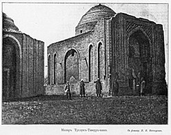
Within Huocheng County, lies the significant ruined site of ancient Almaliq. Additionally, the mausoleum of the first khan of Moghulistan, Tughlugh Timur, is also located within the county.
During the 1760s, nine fortresses were constructed in the Ili River Basin, and four of them were situated within the modern Huocheng County. Huiyuan served as the headquarters of the General of Ili, making it the military and administrative center of Xinjiang until the 1860s.
Suiding County (绥定县) was established in 1888, with Suiding as the county seat. In 1914, the western area of Shuiding County was organized into Khorgas County, later abbreviated to Huocheng County, with Gongchen (Khorgas) as county seat. In 1965 Suiding was renamed Shuiding. In 1966, Shuiding County merged into Huocheng County with Shuiding as the county seat of the new Huocheng County. In 2014, Khorgas became a county-level city separate from Huocheng County.
Administrative divisions
The county includes 6 towns, 2 townships, and 1 ethnic township.
| Name | Simplified Chinese | Hanyu Pinyin | Uyghur (UEY) | Uyghur Latin (ULY) | Number of communities | Population (thousand) | Land area (km2) |
|---|---|---|---|---|---|---|---|
| Towns | |||||||
| Shuiding Town (Süydüng Town) | 水定镇 | Shuǐdìng Zhèn | سۈيدۈڭ بازىرى | süydüng baziri | 13 | 3 | 14.9 |
| Qingshuihe Town (Chingsixoza Town) | 清水河镇 | Qīngshuǐhé Zhèn | چىڭسىخوزا بازىرى | chingsixoza baziri | 15 | 46.7 | 185.2 |
| Lucaogou Town (Losigung Town) | 芦草沟镇 | Lúcǎogōu Zhèn | لۇسىگۇڭ بازىرى | lusigung baziri | 11 | 35.4 | 346 |
| Huiyuan Town (Küre Town) | 惠远镇 | Huìyuǎn Zhèn | كۈرە بازىرى | küre baziri | 4 | 21.4 | 138.6 |
| Sarbulaq Town | 萨尔布拉克镇 | Sà'ěrbùlākè Zhèn | ساربۇلاق بازىرى | sarbulaq baziri | 11 | 28.2 | 431.7 |
| Lengger Town | 兰干镇 | Lángàn Zhèn | لەڭگەر بازىرى | lengger baziri | 13 | 3 | 14.9 |
| Townships | |||||||
| Sendoxoza Township (Sandaohe Township) | 三道河乡 | Sāndàohé Xiāng | سەندوخوزا يېزىسى | sendoxoza yëzisi | 3 | 9.3 | 78.7 |
| Dashigu Township (Daxigou Township) | 大西沟乡 | Dàxīgōu Xiāng | داشىگۇ يېزىسى | dashigu yëzisi | 7 | 10.8 | 252.7 |
| Ethnic Township | |||||||
| Sengung Township (Sangong Township) | 三宫乡 (三宫回族乡) | Sāngōng Xiāng (Sāngōng Huízú Xiāng) | سەنگۇڭ خۇيزۇ يېزىسى | sengung xuyzu yëzisi | 5 | 15 | 126.9 |
Climate
| Climate data for Huocheng, elevation 640 m (2,100 ft), (1991–2020 normals, extremes 1991–present) | |||||||||||||
|---|---|---|---|---|---|---|---|---|---|---|---|---|---|
| Month | Jan | Feb | Mar | Apr | May | Jun | Jul | Aug | Sep | Oct | Nov | Dec | Year |
| Record high °C (°F) | 10.1 (50.2) | 16.6 (61.9) | 28.2 (82.8) | 34.7 (94.5) | 37.1 (98.8) | 36.9 (98.4) | 40.2 (104.4) | 39.4 (102.9) | 36.4 (97.5) | 32.4 (90.3) | 25.2 (77.4) | 14.5 (58.1) | 40.2 (104.4) |
| Mean daily maximum °C (°F) | −1.9 (28.6) | 1.8 (35.2) | 12.2 (54.0) | 21.5 (70.7) | 26.4 (79.5) | 30.3 (86.5) | 32.3 (90.1) | 31.4 (88.5) | 26.8 (80.2) | 18.8 (65.8) | 8.9 (48.0) | 0.6 (33.1) | 17.4 (63.4) |
| Daily mean °C (°F) | −7.7 (18.1) | −3.7 (25.3) | 5.7 (42.3) | 13.9 (57.0) | 18.7 (65.7) | 22.7 (72.9) | 24.4 (75.9) | 23.1 (73.6) | 18.0 (64.4) | 10.4 (50.7) | 2.7 (36.9) | −4.7 (23.5) | 10.3 (50.5) |
| Mean daily minimum °C (°F) | −12.4 (9.7) | −8.4 (16.9) | 0.4 (32.7) | 7.5 (45.5) | 12.0 (53.6) | 16.0 (60.8) | 17.4 (63.3) | 15.7 (60.3) | 10.5 (50.9) | 4.2 (39.6) | −1.6 (29.1) | −8.8 (16.2) | 4.4 (39.9) |
| Record low °C (°F) | −28.3 (−18.9) | −26.7 (−16.1) | −19.3 (−2.7) | −7.0 (19.4) | −0.5 (31.1) | 7.9 (46.2) | 9.5 (49.1) | 4.2 (39.6) | −1.6 (29.1) | −6.7 (19.9) | −16.5 (2.3) | −30.4 (−22.7) | −30.4 (−22.7) |
| Average precipitation mm (inches) | 18.4 (0.72) | 20.1 (0.79) | 17.6 (0.69) | 26.3 (1.04) | 23.5 (0.93) | 27.7 (1.09) | 22.5 (0.89) | 17.8 (0.70) | 12.2 (0.48) | 21.3 (0.84) | 30.0 (1.18) | 22.8 (0.90) | 260.2 (10.25) |
| Average precipitation days (≥ 0.1 mm) | 8.6 | 7.7 | 6.5 | 7.6 | 7.7 | 7.8 | 7.8 | 6.0 | 5.0 | 5.7 | 7.7 | 8.8 | 86.9 |
| Average snowy days | 10.4 | 8.7 | 3.5 | 0.8 | 0.1 | 0 | 0 | 0 | 0 | 0.5 | 4.2 | 10.3 | 38.5 |
| Average relative humidity (%) | 76 | 74 | 63 | 53 | 52 | 53 | 53 | 53 | 54 | 64 | 73 | 77 | 62 |
| Mean monthly sunshine hours | 151.8 | 166.8 | 233.5 | 268.8 | 318.2 | 318.7 | 338.0 | 325.3 | 278.5 | 226.1 | 154.5 | 135.4 | 2,915.6 |
| Percentage possible sunshine | 52 | 55 | 62 | 66 | 69 | 69 | 73 | 77 | 76 | 68 | 55 | 49 | 64 |
| Source: China Meteorological Administration |
Demographics
| Nationality | Percentage | |
| Han | 33.6% | |
| Uyghurs | 26.8% | |
| Huis | 23.8% | |
| Kazakhs | 9.0% | |
| Xibe | 0.4% | |
| Mongols | 0.2% | |
| Others | 6.2% | |
| Source of the population statistics : |
Economy
In agriculture, the local population cultivate wheat, corn and other crops including sugar beet, cotton, tobacco, apples, animal husbandry with cattle and sheep.
The main minerals extracted in the area include coal, phosphorus, iron, gold, silver, copper, limestone, Iceland spar and marble, etc.
Transport
Huocheng is served by China National Highway 312 and the Jinghe-Yining-Khorgas Railway.
There is a border crossing into Kazakhstan at Khorgas, where the road continues to Zharkent in Panfilov District.
The Jinghe–Yining–Khorgas Railway through Huocheng county was completed in 2010, reaching practically to the Kazakhstan border. There are plans to construct a connecting railway line on the Kazakh side, creating China's second railway link to Central Asia besides Alashankou.
Notes
External links
- , at the site of Ili Kazakh Autonomous Prefecture (in Chinese)
- 2007-05-14 at the Wayback Machine (in Chinese)
- (the writer's point of view on how the places should be called) (in Chinese)
- Henry Lansdell, "Russian Central Asia: Including Kuldja, Bokhara, Khiva and Merv", vol. I. available at Google Books; there is also a 2001 facsimile reprint of the 1885 edition, ISBN 1-4021-7762-3. (Chapters XIV-XVI in Volume I describe Lansdell's visit to the area in the early 1880s, soon after the Russian withdrawal). (in English)