Dragon's Tail (peninsula)
In-game article clicks load inline without leaving the challenge.
The Dragon's Tail is a name for the Indochinese Peninsula in Southeast Asia which appeared in medieval Arabian and Renaissance European world maps. It formed the eastern shore of the Great Gulf (Gulf of Thailand) east of the Golden Chersonese (Malay Peninsula), replacing the "unknown lands" which Ptolemy and others had thought surrounded the "Indian Sea".
Name
The peninsula known to modern cartographers as the "Dragon's Tail" or "Tiger's Tail" appeared under various names on different maps.
History

Early history
The peninsula does not appear in any surviving manuscript of Ptolemy's Geography or other Greek geographers. Instead, it is first attested in the Ptolemaic-influenced Book of the Description of the Earth compiled by al-Khwārizmī around 833 AD. Ptolemy's map ended at 180°E of the Fortunate Isles without being able to explain what might lie on the imagined eastern shore of the Indian Ocean or beyond the lands of the Sinae and of Serica in Asia. Chinese Muslims traditionally credit the Companion Saʿd ibn Abi Waqqas with having missionized the country as early as the 7th century; the trading community was large enough that a large-scale massacre is recorded at Yangzhou in 760. Merchants such as Soleiman showed Al-Khwārizmī that the Indian Ocean was not closed as Hipparchus and Ptolemy had held but opened either narrowly or broadly. Al-Khwārizmī left most of Ptolemy's eastern coast but the creation of the strait created a new peninsula, beyond which he placed the Sea of Darkness and the Island of the Jewel.
Age of Discovery
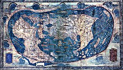

Bartholomew Dias passed the Cape of Good Hope during a major storm in 1488; within a year or two, Martellus had published a world map showing the communication of the Atlantic and Indian Oceans, creating an unconnected south point of Africa and transforming the eastern end of Ptolemy's shoreline into a great peninsula, similar to that described by Al-Khwārizmī. The area was detailed with locations from Marco Polo and other travelers, including positions formerly related to Ptolemy's Golden Chersonese. A similar peninsula then appeared on the Erdapfel globe drafted by Martin of Bohemia in 1492, just prior to Columbus's return. In the mid-16th century, António Galvão mentioned a map that had been purchased in 1428 by Dom Pedro, eldest son of John I, which described the Cape of Good Hope and included "the Strait of Magellan" under the name "Dragon's Tail" (Portuguese: Cola do dragam). Some South American scholars have taken this at face value as evidence of early and thorough exploration of the Americas, but their claims have not been substantiated.

Christopher Columbus—at least initially—believed in the existence of the peninsula, whose position and attendant islands considerably shortened the expected distance from the African coast to East Asia. He may have been guided directly by Martellus's maps. Columbus considered himself to have arrived at Champa, which figured prominently in three inscriptions on Martellus's 1491 map, and cartographers began to draw discoveries in Central America on the eastern shore of the phantom peninsula. Amerigo Vespucci also considered himself to have arrived at this peninsula rather than a new world.
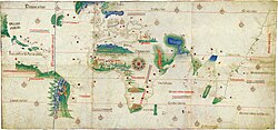
Another form of this peninsula appeared in the 1502 Cantino planisphere smuggled out of Portugal for the Duke of Ferrara. The map has lost the Great Gulf and the peninsula continues to be too large, but it has merged with the Golden Chersonese as a single landform and bent more towards the east, apparently influenced by Arabic sources.
The Portuguese were aware of the peninsula's likely nonexistence by shortly after the fall of Malacca, when Albuquerque acquired a large Javanese map of Southeast Asia. The original was lost aboard the Froll de la Mar shortly afterwards but a tracing by Francisco Rodrigues was sent in its place as part of a letter to the king. Nonetheless, published maps continued to include it in different forms for another century.
Details
The southern end of the peninsula was generally known as the Cape of Cattigara.
Martellus's world maps include labels marking the areas of Upper India (India Superior), Champa (Ciamba Provincia), and Greater Champa (Ciamba Magna Provincia).
See also
- Cà Mau Peninsula
- Golden Peninsula, another peninsula which appeared in early and medieval world maps
Notes
Citations
- al-Khwārizmī (c. 833), The Book of the Description of the Earth.
- Galvão, António (1563), [Treatise on the Various and Sundry Ways that in Times Past Pepper and Spices Came from India to Our Parts & Also on All of the Discoveries Ancient & Modern Which Were Made up to the Year 1550] (PDF), Lisbon: Joam da Barreira. (in Portuguese)
- Galvano, Antonio (1862) [Portuguese version 1563, original translation 1601], Bethune, C.R.D. (ed.), , Translated and edited by Richard Hakluyt, London: T. Richards for the Hakluyt Society (in English and Portuguese).
- Robert J. King, "Finding Marco Polo’s Locach", Terrae Incognitae, vol.50, no.1, April 2018, pp.1-18.
- Lester, Toby (2009), , London: Profile Books, ISBN 978-1-86197-803-5.
- Miller, Greg (15 September 2014), , Wired.
- Rapoport, Yossef; Savage-Smith, Emilie (2008), , in Talbert, Richard J.A.; Unger, Richard W. (eds.), Cartography in Antiquity and the Middle Ages: Fresh Perspectives, New Methods, Koninklijke Brill NV, ISBN 978-90-04-16663-9.
- Richardson, William A.R. (2003), "South America on Maps before Columbus? Martellus's 'Dragon's Tail' Peninsula", Imago Mundi, vol. 55, pp. 25–37, doi:, S2CID.
- Richardson, William A.R. (2011), , in Scott, Anne M.; Hiatt, Alfred; McIlroy, Claire; Wortham, Christopher (eds.), , Farnham: Ashgate Publishing, pp. 93–110, ISBN 9781409426059.
- Siebold, Jim (2011), , Cartographic Images, Oviedo: Henry Davis Consulting, archived from on Apr 8, 2015.
- Sollewijn Gelpke, J.H.F. (1995), "Afonso de Albuquerque's Pre-Portuguese 'Javanese' Map, Partially Reconstructed from Francisco Rodrigues' Book", , vol. 151, Leiden: KITLV, pp. 76–99, doi:, (PDF) from the original on Jul 5, 2024 – via Brill.
- Suárez, Thomas (1999), , Singapore: Periplus Editions, ISBN 9781462906963.
External links
- & at Yale University's Beinecke Rare Book & MS Library