Minnesota State Highway 55
In-game article clicks load inline without leaving the challenge.
Minnesota State Highway 55 (MN 55) is a state highway that runs 221 miles (356 km) across the central part of state taking a diagonal route from its western most at the North Dakota state line near Tenney to its easternmost point at the intersection with U.S. Highway 61 (US 61) in Hastings. In Minneapolis and Golden Valley, portions of the route are also signed as Olson Memorial Highway.
Route description
MN 55 serves as a northwest–southeast route between Elbow Lake, Glenwood, Paynesville, Annandale, Buffalo, Plymouth, Minneapolis, Mendota Heights, and Hastings.
MN 55 begins at the Bois de Sioux River, at the Minnesota—North Dakota state line near Tenney. North Dakota Highway 11 (ND 11) is its counterpoint upon crossing the state line. MN 55 continues east to Tenney, Nashua, and Wendell. The route has a junction with U.S. Highway 59 (US 59) before entering the city of Elbow Lake. US 59/MN 55 runs concurrently for 11 miles (18 km) until reaching Barrett.
MN 55 then continues independently again to Hoffman, Kensington, Farwell, and Lowry before reaching the city of Glenwood. At Glenwood, MN 55 has an intersection with MN 29 and an interchange with MN 28.
The route continues southeast to Sedan and Brooten before reaching its junction with US 71 in Belgrade. MN 55 passes through Regal before reaching its junction with MN 4 and MN 23 at the city of Paynesville.
MN 55 continues east to Eden Valley and Watkins before reaching its junction with MN 15 at Kimball.
The route has a junction with MN 24 in Annandale. MN 55 continues to Maple Lake and then Buffalo, where it has a junction with MN 25.
MN 55 enters the Twin Cities area at Rockford and Greenfield, continuing east to Medina and Plymouth. MN 55 has a junction with Interstate 494 (I-494) in Plymouth. MN 55 continues east and has a junction with US 169 at the Plymouth–Golden Valley boundary line. MN 55 continues through Golden Valley to its junction with MN 100. The route then continues east and enters the city of Minneapolis.
The highway has been designated Olson Memorial Highway, named for Floyd B. Olson, a popular Minnesota governor of Norwegian ancestry. Olson grew up in North Minneapolis, near where the highway runs. While the entire route is designated as the Olson Memorial Highway, it is only consistently signed as such between Interstate 494 and N 7th Street in Minneapolis. The part of MN 55 southeast of downtown is known as Hiawatha Avenue. Light rail trains on the Blue Line, and Little Earth Trail and Hiawatha LRT Trail for bicyclists/pedestrians, run parallel to the highway for much of the Hiawatha Avenue stretch.

MN 55 runs concurrently along I-94/US 52. MN 55 exits just before downtown at the westbound I-94/northbound US 52 exit, and leaves the concurrency at the exit for the Olson Highway, marked with the MN 55 shield. Eastbound, MN 55 leaves the Olson Highway at the interchange for I-94 eastbound/US 52 southbound, and leaves the freeway at the exit for Hiawatha Avenue, which is also marked with the MN 55 shield.
There has been some controversy with expansion of the highway.[citation needed] An area known as Camp Coldwater, considered by some as the "birthplace of Minnesota", was dug up during some construction. MN 55 joins with MN 62 at this point.
Fort Snelling State Park is located near the junction of MN 55 and MN 5. The park entrance is located on MN 5 at Post Road.
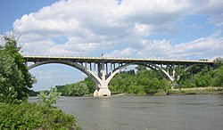
MN 55 crosses the Minnesota River via the Mendota Bridge, which was the longest continuous bridge made of poured concrete when it was completed in 1926. It is 4,119 feet (1,255 m) in length.
The route enters Mendota Heights, diverges from MN 62, and then has a junction with MN 13.
MN 55 continues southeast through Eagan, joining briefly with MN 149. The route then has a junction with MN 3 in Inver Grove Heights. MN 55 then runs concurrently with US 52 through Inver Grove Heights and into Rosemount. At Rosemount, MN 55 leaves US 52. MN 55 continues independently again to its eastern terminus at its intersection with US 61 in the city of Hastings.
History
MN 55 was authorized in 1933.
The original alignment for MN 55 in Minneapolis was along old US 52 (now County State-Aid Highway 81, CSAH 81) to Rockford Road, then Rockford Road to MN 55's present-day alignment (now CSAH 9). The present-day alignment was constructed in the early 1950s.
In July 2005, the section of MN 55 that runs through downtown Minneapolis was turned back to local maintenance. To fill the gap, MN 55 was rerouted along I-94/US 52.
Major intersections
| County | Location | mi | km | Destinations | Notes |
|---|---|---|---|---|---|
| Bois de Sioux River | 0.000 | 0.000 | ND 11 west – Fairmount | Continuation into North Dakota | |
| North Dakota–Minnesota state line | |||||
| Wilkin | Campbell Township | 3.496 | 5.626 | US 75 – Wheaton, Breckenridge | |
| Champion Township | 10.706 | 17.230 | MN 9 – Morris, Breckenridge | ||
| Grant | Pomme de Terre Township | 27.832 | 44.791 | US 59 north – Fergus Falls | Western end of US 59 overlap |
| Elbow Lake | 31.230 | 50.260 | MN 79 east – Evansville, Alexandria | Western terminus of MN 79; access to Elbow Lake Medical Center | |
| 31.892 | 51.325 | CSAH 54 south – Herman | Former MN 54 | ||
| Barrett | 38.820 | 62.475 | US 59 south – Morris | Eastern end of US 59 overlap | |
| Hoffman | 45.686 | 73.524 | MN 27 – Wheaton, Alexandria | ||
| Douglas | No major junctions | ||||
| Pope | Ben Wade Township | 61.135 | 98.387 | MN 114 north – Garfield | Western end of MN 114 overlap |
| Lowry | 61.798 | 99.454 | MN 114 south – Starbuck | Eastern end of MN 114 overlap | |
| Reno Township | 68.804 | 110.729 | MN 29 – Glenwood, Alexandria | ||
| Glenwood | 70.914 | 114.125 | MN 28 – Glenwood, Sauk Centre, Morris | Interchange | |
| Stearns | Belgrade | 93.643 | 150.704 | US 71 south – Willmar | Western end of US 71 overlap |
| Crow River Township | 94.636 | 152.302 | US 71 north – Sauk Centre | Eastern end of US 71 overlap | |
| Kandiyohi | Roseville Township | 105.917 | 170.457 | MN 4 north – Meire Grove | Western end of MN 4 overlap |
| Stearns | Paynesville | 108.205 | 174.139 | MN 23 – Willmar, St. Cloud | Interchange |
| 109.527 | 176.267 | CSAH 66 (Lake Avenue) | Former MN 124; access to CentraCare Paynesville Hospital | ||
| Meeker | Union Grove Township | 113.487 | 182.640 | MN 4 south – Grove City | Eastern end of MN 4 overlap |
| Eden Valley | 119.497 | 192.312 | MN 22 – Litchfield, Richmond | ||
| Stearns | Kimball | 131.977 | 212.396 | MN 15 / MN 24 south – Dassel, St. Cloud | Western end of MN 24 overlap |
| Wright | Annandale | 141.622 | 227.919 | MN 24 north – Clearwater | Eastern end of MN 24 overlap |
| Buffalo | 155.195 | 249.762 | MN 25 (Central Avenue) – Monticello | Access to Buffalo Hospital | |
| Hennepin | Medina | 176.393 | 283.877 | CSAH 101 north (Sioux Drive) | Former MN 101 north |
| Plymouth | 177.572 | 285.774 | CSAH 101 south (Peony Lane) – Wayzata | Former MN 101 south | |
| 180.515 | 290.511 | I-494 | Interchange; I-494 Exit 22 | ||
| Plymouth–Golden Valley line | 183.052 | 294.594 | US 169 | Interchange | |
| Golden Valley | 186.600 | 300.304 | MN 100 | Interchange; MN 100 exit 9 | |
| Minneapolis | 189.640 | 305.196 | I-94 west (US 52) | Western end of I-94 overlap; I-94 exit 230 | |
| See I-94 | |||||
| 191.887 | 308.812 | I-94 east (US 52 / US 12) | Eastern end of I-94 overlap; I-94 exit 234A | ||
| 191.944 | 308.904 | I-35W north / 7th Street / 3rd Street / Washington Avenue – University of Minnesota | Westbound left exit and eastbound left entrance | ||
| 192.619 | 309.990 | To CSAH 5 (Franklin Avenue) / CSAH 152 (Cedar Avenue) | Interchange | ||
| 193.521 | 311.442 | CSAH 3 (East Lake Street) | SPUI interchange | ||
| 195.527 | 314.670 | CSAH 46 (46th Street) / Great River Road (National Route) | Western end of Great River Road overlap | ||
| Unorganized Territory of Fort Snelling | 197.430 | 317.733 | MN 62 west (Crosstown Highway) | Interchange; western end MN 62 overlap | |
| 198.052 | 318.734 | CSAH 204 south (Bloomington Road) | Fort Snelling Historic Site signed westbound | ||
| 198.373 | 319.250 | MN 5 – Minneapolis–Saint Paul International Airport, St. Paul | |||
| Minnesota River | 198.424– 199.204 | 319.332– 320.588 | Mendota Bridge | ||
| Dakota | Mendota Heights | 199.357 | 320.834 | MN 62 east | Eastern end of MN 62 overlap; eastbound exit and westbound entrance |
| 200.141 | 322.096 | MN 13 / Great River Road (National Route) – MN 62 | At-grade intersection; Eastern end Great River Road overlap | ||
| Eagan | 202.409 | 325.746 | MN 149 north (Dodd Road north) to I-494 | Western end of MN 149 overlap | |
| 202.943 | 326.605 | MN 149 south (Dodd Road south) | Eastern end of MN 149 overlap | ||
| Inver Grove Heights | 205.005 | 329.924 | MN 3 (South Robert Trail) | ||
| 206.421 | 332.202 | CR 73 (Barnes Avenue) | Eastbound exit and westbound entrance | ||
| 206.753 | 332.737 | US 52 north (Lafayette Freeway) – St. Paul | Western end of US 52 overlap; westbound exit and eastbound entrance | ||
| 328.733 | 529.044 | CSAH 56 (Concord Boulevard) / Great River Road (National Route) | Former MN 56; western end of Great River Road overlap | ||
| Inver Grove Heights–Rosemount line | 210.290 | 338.429 | 117th Street | ||
| Rosemount | 211.074 | 339.691 | US 52 south – Rochester | Eastern end of US 52 overlap; eastern end of freeway section; interchange eastbound, access via connector road westbound | |
| 213.919 | 344.269 | CSAH 42 west (142nd Street) – Rosemount | Western end of CSAH 42 overlap | ||
| Nininger Township | 215.689 | 347.118 | CSAH 85 south / CSAH 42 east / Great River Road (National Route) | Eastern end of CSAH 42 and Great River Road overlap | |
| Hastings | 220.572 | 354.976 | US 61 / Great River Road – Red Wing | Eastern terminus | |
| 1.000 mi = 1.609 km; 1.000 km = 0.621 mi Concurrency terminus |