Roads in Ukraine
In-game article clicks load inline without leaving the challenge.

Roads in Ukraine's transportation network are divided into two main categories: general-use roads, which consist of streets and roads in cities, villages, and other populated areas; and specialized roads, which include official, private, and special-use roads. Most members of the public travel on general-use roads, the most prominent of which are part of the international E-road network. However, high-speed highways, locally known as avtomahistrali (motorways) or shvydkisni dorohy (expressways), are rare and only exist on certain segments of major routes. In early 2010, in preparation for Ukraine co-hosting the UEFA Euro 2012 football tournament, significant infrastructure improvement projects were announced by the newly-established Ministry of Infrastructure of Ukraine, then headed by Borys Kolesnikov. These efforts fell short of expectations in some areas, and the road network at-large is still in need of significant renovation.
Ukraine inherited its transportation network from the Ukrainian SSR (Soviet Ukraine), whose roads were integrated into the larger Soviet road system. In 1940, Ukraine had only 270,700 kilometers of roads, only 10.8% of which had paved surfaces. The present-day road network was mostly built during the 1960s and 1970s. 99% of roads in the modern network are public-use, of which 12% are considered to have 'national importance' and 87% to have 'local importance'. The whole network of all automobile roads (roadways) is approximately 169,000km (105,000mi) long, of which 165,000km (103,000mi) is hard surfaced. Some critics point out that road conditions and road safety are in dangerous states of disarray.
Beginning in 2020, the "Great Construction" project facilitated the reconstruction or renovation of many roads. The Russian invasion of Ukraine has also heavily impacted infrastructure work in the country, leading to billions of dollars (USD) in construction costs. In 2023 alone, the Government of Ukraine reported making more than 2,000 kilometers of emergency repairs on motorways, highways, and other national roads.More than 25,000km (16,000mi) of state and local roads, and 344 bridges and overpasses, were destroyed or damaged as a result of the invasion.
Overview
After the fall of the Soviet Union, all road service state bodies within Ukraine were reorganized. Ukravtodor was established as a state agency and corporation in 1990, replacing the Ministry of Roadways of Soviet Ukraine as the body governing automobile roads in modern Ukraine. It is supplemented by a project institute Ukrhiprodor which designs objects of road management. Ukravtodor is supervised by the Ministry of Infrastructure of Ukraine. On February 28, 2002, the state-owned open stock company Avtomobilni dorohy Ukrainy (ADU, lit.'Ukrainian motor roads') was created by Presidential Decree. The company was directly involved in road construction and maintenance. In 2016 ADU was merged into Ukravtodor, and the latter now owns 100% of ADU's shares.
In 2015, the World Bank Group approved a US$560 million loan to improve road conditions in Ukraine, particularly along the M03 route between Poltava and Kharkiv.
In 2016, many of Ukraine's major provincial highways were in very poor condition, with Ukravtodor reporting that 97% of the country's roads needed repair. This high figure was attributed mostly to corruption-driven budget allocations and to lackluster enforcement of weight restrictions on trucks. That same year, the road repair budget was set at about ₴20 billion. In 2017, the Groysman government began a three year large-scale renovation of Ukraine's motorway infrastructure, with the road budget increasing to ₴42 billion in 2018, ₴51 billion in 2019, and reaching a record high of ₴70 billion in 2020.
Ukraine's increased efforts at road maintenance and construction have shown some tangible results: on the World Economic Forum's Quality of Roads Report, Ukraine rose from 139th place in 2014 to 119th place in 2019, improving 20 places in five years.
Classifications

The state highways have the index letters of M, H, P, and T, each standing for a respective letter in Cyrillic. These 'state-importance' roads are utilized by the European E-network of highways.
- Both the M-network (Ukrainian:Міжнародні,romanized:Mizhnarodni - International) and the H-network (Ukrainian:Національні,romanized:Natsionalni - National) of roads use two-digit numbers ranging from 01 to 33. These roads are designed for major transportation corridors across the country and form part of the European highway system.
- The P-network (Ukrainian:Регіональні,romanized:Rehionalni - Regional) of roads also uses two-digit numbers, ranging from 01 to 84.
- The T-network (Ukrainian:Територіальні,romanized:Terytorialni - Territorial) of roads form the territorial network within each of the first-level administrative divisions of Ukraine (oblasts of Ukraine), and their index is a four-digit number where two of the digits identify the region where a given road is located.
Avtomahistral

In Ukraine, a high-speed divided highway or motorway is called an avtomahistral (Ukrainian:автомагістраль). Currently, these act not as a distinct route network, but rather as a standard to which portions of the M-roads are adapted.
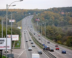
In the late 2000's, two of the first improved avtomahistral motorways were opened: the Kyiv – Boryspil route (Ukrainian:Автомагістраль Київ - Бориспіль), which takes up the segment of the M03 road connecting the capital with Boryspil International Airport; and the M29 which connects Kharkiv and Dnipro by running parallel with the M18. The Kyiv – Boryspil freeway stretches for 18km (11mi) and has a traffic capacity of 40,000 vehicles per day.
Road characteristics categories
Beyond classification by geographic levels, the roads in Ukraine are also categorized by their ability to handle varying degrees of traffic. There are five categories, with Category I split into A and B subcategories. Although all Category I roads are considered "avtomahistral", not all of them would be considered real motorways.[why?] Since around 2010, the two major avtomahistrals, Kyiv – Boryspil and Kharkiv – Dnipro, have been deemed the top roads of category IA.
| Categories | IA | IB | II | III | IV | V |
| Average traffic intensity daily (in vehicles) | >7,000 | >7,000 | >3,000-7,000 | >1,000-3,000 | >200-1,000 | <200 |
| Maximum traffic intensity daily (in vehicles) | >14,000 | >14,000 | >6,000-14,000 | >2,000-6,000 | >400-2,000 | <400 |
| Estimated traffic speed (km/h) | 130 | 110 | 90 | 90 | 90 | 90 |
| Number of lanes in both directions | 4-6 | 4-6 | 2 | 2 | 2 | 1 (total) |
| Width of lanes (m) | 3,75 | 3,75 | 3,75 | 3,75 | 3,5 | 4,5 |
| Width of median (m) | 6 | 5 | - | - | - | - |
| Width of an edge reinforced lane on median (m) | 1 | 1 | - | - | - | - |
| Width of an edge reinforced lane on roadside (m) | 0,75 | 0,75 | 0,75 | 0,5 | - | - |
| Total road width (m) | 28,5 | 27,5 | 15 | 12 | 10 | 6 |
| Radius of a curvature on a turn (m) | 1,200 | 800 | 800 | 600 | 300 | 150 |
| Maximum lengthwise gradient (per mil) | 30 | 40 | 40 | 50 | 60 | 70 |
List of international E-road network routes in Ukraine
The international E-road network and its 'European routes' run throughout the continent of Europe, in addition to adjacent islands, parts of Central Asia, the Caucasus, and Asia Minor. The European routes in Ukraine mostly travel along Ukrainian 'M-network' or 'International' roads.

In the list below, main routes are indicated by a green background. These have numbers ending in either zero (0) or five (5). Obsolete routes are indicated by a red background. Odd-numbered routes run north-south and even-numbered routes run east-west.
| Highway | Local routes | Length in Ukraine | Notes |
|---|---|---|---|
| E38 | P 65 | 37km | The shortest (Ukraine-only length) |
| E40 | M 10 – M 06 – M 03 – M 04 | 1334km | The longest (Ukraine-only length) |
| E50 | M 08 – M 06 – M 12 – M 04 – M 03 | ||
| E58 | M 08 – M 06 – P 54 – M 23 – P 55 ... (Moldova) ... M 16 – M 14 | ||
| E81 | P 54 – M 23 – P 55/DN1C | 41km | |
| E85 | M 19 – M 19 | ||
| E87 | M 15 | ||
| E93 | Changed to E95 | ||
| E95 | M 01 – M 05 ... (Turkey) | 692km | Ferry service in Odesa |
| E97 | M 17 ... (Russia) | 423.6km | Uses Kerch Strait ferry |
| E101 | M 01 – M 02 | ||
| E105 | M 18 – M 20 | 777km | |
| Auxiliary routes | |||
| E372 | M 09 | 62.5km | |
| E373 | M 07 | 486.5km | |
| E381 | Kyiv – Hlukhiv | ||
| E391 | Hlukhiv (same as E101) | 160km | |
| E471 | M 06 | 221km | Located entirely within Ukraine |
| E573 | M 06 | 26km | |
| E577 | Changed to E584 | ||
| E581 | M 16 | 58.7km | |
| E583 | M 21 | 260km | |
| E584 | M 13 – M 12 – M 04 – M 22 | 507km |
Transportation corridors
Ten Pan-European corridors for transport were defined in 1994 with the goal of improving connectivity in Central and Eastern Europe. Ukraine houses portions of three of these corridors: III (Brussels – Dresden – Kraków – Kyiv), V (Venice – Budapest – Lviv – Kyiv), and IX (Helsinki – Saint-Petersburg – Homiel – Kyiv – Chișinău – Bucharest – Thrace).
Border checkpoints
| Country | Highway | Nearest settlement | Region |
|---|---|---|---|
| Russia Russia | E101 | Bachivsk | Sumy |
| E58 | Novoazovsk | Donetsk | |
| E50 | Dovzhanskyi | Luhansk | |
| E105 | Shcherbakivka | Kharkiv | |
| E40 | Izvaryne | Luhansk | |
| Poland Poland | Shehyni | Lviv | |
| Krakivets | |||
| E372 | Rava-Ruska | ||
| Ustyluh | Volyn | ||
| E373 | Yahodyn | ||
| Hungary Hungary | E573 | Kosyny | Zakarpattia |
| Slovakia Slovakia | E50 | Uzhhorod | |
| Maly Berezny | |||
| Moldova Moldova | Kuchurhan | Odesa | |
| Mamalyha | Chernivtsi | ||
| E584 | Platonove | Odesa | |
| E583 | Mohyliv-Podilskyi | Vinnytsia | |
| Romania Romania | E81 | Velyka Kopania | Zakarpattia |
| E87 | Reni | Odesa | |
| E85 | Terebleche | Chernivtsi | |
| Belarus Belarus | Domanove | Volyn | |
| E95 | Novi Yarylovychi | Chernihiv |
Notable roadworks projects
Note that some of these projects may have been affected by the Russian invasion of Ukraine from 2022 onwards.
Dnipro – Reshetylivka Highway (H-31)
As of 2020, renovation has been occurring on the H-31 highway, which connects the capital with Dnipro, a major industrial hub. The largest construction site is located in the Poltava region, where a 7-kilometre section of concrete-surface highway is being built from scratch. The bypass section around Poltava includes a 518-metre long viaduct.
Kyiv – Odesa Highway (M-05)
As of 2020, roadworks continue with the goal of reconstructing the full 453km length of the Kyiv–Odesa Highway. Reconstruction is scheduled to finish in 2021. According to Ukravtodor, the reconstruction is "complex", requiring work on additional auxiliary road services such as the installation of weigh in motion (WiM) complexes, grade-separated intersections, and the abandonment of left-turning lanes.
Zhytomyr Northern Bypass (M-06)
As of 2020, the Northern Bypass section of the M-06 Highway around Zhytomyr is being expanded to four lanes with an increased maximum speed of 110km/h. The project includes four multi-level interchanges and three grade-separated railway crossings. Construction is scheduled to finish in 2020.
Rivne Northern Bypass, Phase One
A two-lane bypass road is currently under construction around the city of Rivne. The first phase is a built-from-scratch 6km road section linking the N-25 and T-18-32 highways. The project aims to relieve heavy transit traffic in the city centre and includes a 280-metre-long overpass above a ravine.
Local importance routes
The 'local importance' roads have three classes but only two indexes (T and O) as the raion-level network of roads does not have an implemented index. Local road indexes are also supplemented by an oblast index noting where they are located.
| Index | Oblast/City | Road length, km | Index | Oblast/City | Road length, km | Index | Oblast/City | Road length, km |
|---|---|---|---|---|---|---|---|---|
| 01 | Crimea | 6,605 | 10 | Kyiv Oblast | 8,490 | 20 | Ternopil Oblast | 5,063 |
| 02 | Vinnytsia Oblast | 9,519 | 12 | Kirovohrad Oblast | 6,545 | 21 | Kharkiv Oblast | 9,551 |
| 03 | Volyn Oblast | 6,199 | 13 | Luhansk Oblast | 5,810 | 22 | Kherson Oblast | 4,950 |
| 04 | Dnipropetrovsk Oblast | 9,182 | 14 | Lviv Oblast | 8,334 | 23 | Khmelnytskyi Oblast | 7,136 |
| 05 | Donetsk Oblast | 8,052 | 15 | Mykolaiv Oblast | 4,831 | 24 | Cherkasy Oblast | 6,118 |
| 06 | Zhytomyr Oblast | 8,513 | 16 | Odesa Oblast | 8,232 | 25 | Chernihiv Oblast | 7,680 |
| 07 | Zakarpattia Oblast | 3,330 | 17 | Poltava Oblast | 8,836 | 26 | Chernivtsi Oblast | 2,869 |
| 08 | Zaporizhzhia Oblast | 6,974 | 18 | Rivne Oblast | 5,056 | 27 | Sevastopol city | |
| 09 | Ivano-Frankivsk Oblast | 4,160 | 19 | Sumy Oblast | 7,281 |
The list is arranged in Cyrillic alphabetical order, except for Chernihiv Oblast, which precedes Chernivtsi Oblast. As an example, the territorial highway 22 in Rivne Oblast would be identified as 'T-18-22' since 18 is the index number for the Rivne Oblast. The T-network (Territorial) roads have four-digit codes, with unique two-digit identifiers within each oblast. The Oblast network (O-network) roads, on the other hand, each have six-digit codes and no secondary hyphen. For example, a highway in Kharkiv Oblast would have the code 'O-21xxxx'.
Special routes
The two main technical terms for special routes in Ukraine are pid'yizd (Ukrainian: під'їзд) and ob'yizd (Ukrainian: об'їзд). A pid'yizd route is usually an access route akin to a spur that splits from the main route towards an important geographic point such as a city, airport, or park. An ob'yizd route is a type of ring road which is not necessarily complete, similar in some cases to bypass routes, business routes, or truck routes.
Historical routes
- Muravsky Trail Izium Trail, a branch of the Muravsky Trail Kalmius Route, a branch of the Muravsky Trail
- Bila Tserkva Road
- Silk Road
- Berlad Road
- Route from the Varangians to the Greeks
- Chumak Route
- Black Route Kuchma Route, a branch of the Black Route
- Romodanovsky Route
- Kraków Road
- Kolky Route
- Kyiv Route
- Zaloha Route
Populated area roadways
Types of roadways in populated areas include:
- Vulytsia (street), the most common and generic type of a roadway within a populated area; the English name is becoming more widely used
- Shose, a broad limited-access road built for high-speed traffic for big distances; also defined as a generally accessible road (especially a main road) that connects cities or settlements
- Prospekt, a term for a broad, long, and straight road in big cities
- Bulvar, a scenic broad road similar to a boulevard
- Naberezhna, a roadway running along a body of water (e.g. sea, river, or lake)
- Obiizna/kiltseva, a roadway around a city
- Provulok, a backstreet or side street
See also
- State Highways (Ukraine) for a list of state (national) highways
- Transport in Ukraine
Sources
- at theWayback Machine(archived January 9, 2008)
- 2021-03-26 at theWayback Machine
- 2012-03-10 at theWayback Machine
- , , , 2021-03-26 at theWayback Machine
- ,
- 2011-03-14 at theWayback Machine
- . Cabinet of Ukraine. January 1, 2013