Territorial evolution of Arizona
In-game article clicks load inline without leaving the challenge.


The following timeline traces the territorial evolution of the U.S. State of Arizona.
Timeline
- Historical territorial claims of Spain in the present State of Arizona: Nueva Vizcaya, 1562–1821 Santa Fé de Nuevo Méjico, 1598–1821 Sonora y Sinaloa, 1732–1821 Treaty of Córdoba of 1821
- Historical territorial claims of Mexico in the present State of Arizona: Santa Fé de Nuevo México, 1821–1848 Sonora y Sinaloa (Estado de Occidente), 1824–1830 Sonora since 1830 Treaty of Guadalupe Hidalgo of 1848 Gadsden Purchase of 1853
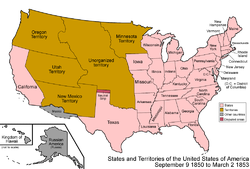
- Historical political divisions of the United States in the present State of Arizona: Unorganized territory created by the Treaty of Guadalupe Hidalgo, 1848–1850 Compromise of 1850 State of Deseret (extralegal), 1849–1850 Territory of New Mexico, 1850–1912 Gadsden Purchase of 1853 American Civil War, 1861–1865 Arizona Territory (CSA), 1861–1865 Territory of Arizona, 1863–1912 North-western corner of the Arizona Territory is transferred to the State of Nevada, 1867 State of Arizona since February 14, 1912 Mexican Boundary Exchanges: In 1927 under the Banco Convention of 1905, the U.S. acquired two bancos from Mexico at the Colorado River border with Arizona. Farmers Banco, covering 583.4 acres (2.361 km2), a part of the Cocopah Indian Reservation at 32°37′27″N 114°46′45″W/32.62417°N 114.77917°W/ 32.62417; -114.77917, was ceded to the U.S. with controversy. Fain Banco (259 acres (1.05 km2)) at 32°31′32″N 114°47′28″W/32.52556°N 114.79111°W/ 32.52556; -114.79111 also became U.S. soil.
See also
California Territorial evolution of California
Colorado List of territorial claims and designations in Colorado
Nevada Territorial evolution of Nevada
New Mexico Territorial evolution of New Mexico
Utah Territorial evolution of Utah