Amador County, California
In-game article clicks load inline without leaving the challenge.
Amador County (/ˈæmədɔːr/ ⓘ) is a county located in the U.S. state of California, in the Sierra Nevada. As of the 2020 census, the population was 40,474. The county seat is Jackson. Amador County, located within California's Gold Country, is known as "The Heart of the Mother Lode." There is a substantial viticulture industry in the county.
History


Amador County was created by the California Legislature on May 11, 1854, from parts of Calaveras and El Dorado counties. It was organized on July 3, 1854. In 1864, part of the county's territory was given to Alpine County.
The county is named for José María Amador, a soldier, rancher, and miner, born in San Francisco in 1794, the son of Sergeant Pedro Amador (a Spanish soldier who settled in California in 1771) and younger brother to Sinforosa Amador.
In 1848, Jose Maria Amador, with several Native Americans, established a successful gold mining camp near the present town of Amador City. In Spanish, the word amador means "one who loves". Some of the Mother Lode's most successful gold mines were located in Amador County, including the Kennedy, Argonaut, and Keystone.
During the outbreak of Civil War the county organized Company C, 1st California Infantry and Company D, 4th California Infantry. Not everyone supported the Union; in April 1862 when the stars and stripes flew from a house a local judge cursed at it.
- Company C, "Amador Volunteers"
There are numerous gold mines in Amador County including the Argonaut Mine, the Kennedy Mine, the Central Eureka, and the Lincoln. The Kennedy Mine in Jackson was the deepest gold mine of its time. The federal government closed all of the Mother Lode's mines in 1942 because they were considered non-essential to the war effort.[citation needed]
Geography
According to the U.S. Census Bureau, the county has a total area of 606 square miles (1,570 km2), of which 595 square miles (1,540 km2) is land and 11.4 square miles (30 km2) (1.9%) is water. It is the fifth-smallest county in California by land area and second-smallest by total area. Water bodies in the county include Lake Amador, Lake Camanche, Pardee Reservoir, Bear River Reservoir, Silver Lake, Sutter Creek, Cosumnes River, Mokelumne River, and Lake Tabeaud. Thirty-seven miles of the North Fork and main Mokelumne River were added to the California Wild and Scenic Rivers System on June 27, 2018, when Governor Edmund G. "Jerry" Brown signed Senate Bill 854.
Amador County is located approximately 45 miles (72 km) southeast of Sacramento in the part of California known as the Mother Lode, or Gold Country in the Sierra Nevada.
Amador County ranges in elevation from approximately 250 feet (76 m) in the western portion of the county to over 9,000 feet (2,700 m) in the eastern portion of the county, the tallest point being Thunder Mountain. The county is bordered on the north by the Cosumnes River and El Dorado County and on the south by the Mokelumne River and Calaveras County, on the west by Sacramento and San Joaquin Counties, and the east by Alpine County.
Adjacent counties
- El Dorado County – north
- Alpine County – east
- Calaveras County – south
- San Joaquin County – southwest
- Sacramento County – west
National protected area
- Eldorado National Forest (part)
- Mokelumne Wilderness (part)
Demographics
| Census | Pop. | Note | %± |
|---|---|---|---|
| 1860 | 10,930 | — | |
| 1870 | 9,582 | −12.3% | |
| 1880 | 11,384 | 18.8% | |
| 1890 | 10,320 | −9.3% | |
| 1900 | 11,116 | 7.7% | |
| 1910 | 9,086 | −18.3% | |
| 1920 | 7,793 | −14.2% | |
| 1930 | 8,494 | 9.0% | |
| 1940 | 8,973 | 5.6% | |
| 1950 | 9,151 | 2.0% | |
| 1960 | 9,990 | 9.2% | |
| 1970 | 11,821 | 18.3% | |
| 1980 | 19,314 | 63.4% | |
| 1990 | 30,039 | 55.5% | |
| 2000 | 35,100 | 16.8% | |
| 2010 | 38,091 | 8.5% | |
| 2020 | 40,474 | 6.3% | |
| 2025 (est.) | 41,876 | 3.5% | |
| U.S. Decennial Census 1790–1960 1900–1990 1990–2000 2010 2020 |
2020 census
As of the 2020 census, the county had a population of 40,474. The median age was 51.6 years. 15.9% of residents were under the age of 18 and 28.4% of residents were 65 years of age or older. For every 100 females there were 119.9 males, and for every 100 females age 18 and over there were 121.9 males age 18 and over.
There were 15,678 households in the county, of which 22.6% had children under the age of 18 living with them and 24.7% had a female householder with no spouse or partner present. About 27.5% of all households were made up of individuals and 15.8% had someone living alone who was 65 years of age or older.
There were 18,805 housing units, of which 16.6% were vacant. Among occupied housing units, 75.7% were owner-occupied and 24.3% were renter-occupied. The homeowner vacancy rate was 2.2% and the rental vacancy rate was 6.3%.
30.8% of residents lived in urban areas, while 69.2% lived in rural areas.
The racial makeup of the county was 76.8% White, 3.1% Black or African American, 1.9% American Indian and Alaska Native, 1.4% Asian, 0.2% Native Hawaiian and Pacific Islander, 7.0% from some other race, and 9.6% from two or more races. Hispanic or Latino residents of any race comprised 14.9% of the population.
Racial and ethnic composition
| Race / Ethnicity (NH = Non-Hispanic) | Pop 1980 | Pop 1990 | Pop 2000 | Pop 2010 | Pop 2020 | % 1980 | % 1990 | % 2000 | % 2010 | % 2020 |
|---|---|---|---|---|---|---|---|---|---|---|
| White alone (NH) | 17,820 | 25,129 | 28,920 | 30,325 | 29,725 | 92.26% | 83.65% | 82.39% | 79.61% | 73.44% |
| Black or African American alone (NH) | 151 | 1,670 | 1,348 | 938 | 1,215 | 0.78% | 5.56% | 3.84% | 2.46% | 3.00% |
| Native American or Alaska Native alone (NH) | 336 | 461 | 538 | 547 | 577 | 1.74% | 1.53% | 1.53% | 1.44% | 1.43% |
| Asian alone (NH) | 72 | 200 | 326 | 396 | 554 | 0.37% | 0.67% | 0.93% | 1.04% | 1.37% |
| Native Hawaiian or Pacific Islander alone (NH) | x | x | 29 | 63 | 73 | x | x | 0.08% | 0.17% | 0.18% |
| Other race alone (NH) | 18 | 59 | 178 | 130 | 249 | 0.09% | 0.20% | 0.51% | 0.34% | 0.62% |
| Mixed race or Multiracial (NH) | x | x | 635 | 936 | 2,067 | x | x | 1.81% | 2.46% | 5.11% |
| Hispanic or Latino (any race) | 917 | 2,520 | 3,126 | 4,756 | 6,014 | 4.75% | 8.39% | 8.91% | 12.49% | 14.86% |
| Total | 19,314 | 30,039 | 35,100 | 38,091 | 40,474 | 100.00% | 100.00% | 100.00% | 100.00% | 100.00% |
2010 census
The 2010 United States census reported that Amador County had a population of 38,091. The racial makeup of Amador County was 33,149 (87.0%) White, 962 (2.5%) African American, 678 (1.8%) Native American, 419 (1.1%) Asian, 77 (0.2%) Pacific Islander, 1,450 (3.8%) from other races, and 1,356 (3.6%) from two or more races. Hispanic or Latino of any race were 4,756 persons (12.5%).
| Place | Type | Total population | White | African American | Native American | Asian | Pacific Islander | Other races | Two or more races | Hispanic or Latino (of any race) |
|---|---|---|---|---|---|---|---|---|---|---|
| Amador County | County | 38,091 | 33,149 | 962 | 678 | 419 | 77 | 1,450 | 1,356 | 4,756 |
| Amador City | City | 185 | 171 | 0 | 4 | 2 | 0 | 2 | 6 | 11 |
| Ione | City | 7,918 | 5,826 | 824 | 173 | 110 | 21 | 678 | 286 | 1,991 |
| Jackson† | City | 4,651 | 4,090 | 32 | 94 | 60 | 4 | 185 | 186 | 520 |
| Plymouth | City | 1,005 | 850 | 3 | 18 | 6 | 2 | 70 | 56 | 183 |
| Sutter Creek | City | 2,501 | 2,272 | 10 | 34 | 65 | 5 | 40 | 75 | 219 |
| Buckhorn | CDP | 2,429 | 2,259 | 9 | 37 | 25 | 4 | 47 | 48 | 168 |
| Buena Vista | CDP | 429 | 365 | 1 | 23 | 0 | 0 | 12 | 28 | 35 |
| Camanche North Shore | CDP | 979 | 860 | 3 | 14 | 12 | 3 | 38 | 49 | 150 |
| Camanche Village | CDP | 847 | 762 | 0 | 9 | 8 | 4 | 31 | 33 | 121 |
| Drytown | CDP | 167 | 153 | 0 | 0 | 1 | 0 | 2 | 11 | 11 |
| Fiddletown | CDP | 235 | 215 | 0 | 5 | 1 | 0 | 8 | 6 | 22 |
| Kirkwood‡ | CDP | 61 | 59 | 0 | 1 | 1 | 0 | 0 | 0 | 2 |
| Martell | CDP | 282 | 234 | 0 | 14 | 0 | 5 | 14 | 15 | 36 |
| Pine Grove | CDP | 2,219 | 2,027 | 9 | 36 | 9 | 6 | 49 | 83 | 202 |
| Pioneer | CDP | 1,094 | 1,017 | 0 | 34 | 1 | 2 | 12 | 28 | 52 |
| Red Corral | CDP | 1,413 | 1,259 | 24 | 15 | 12 | 3 | 33 | 67 | 147 |
| River Pines | CDP | 379 | 324 | 0 | 5 | 4 | 0 | 8 | 38 | 31 |
| Volcano | CDP | 115 | 109 | 0 | 2 | 2 | 0 | 0 | 2 | 7 |
| All others not CDPs (combined) | Others not CDPs | 11,182 | 10,297 | 47 | 160 | 100 | 18 | 221 | 339 | 848 |
† County seat ‡ Data for Amador County area of this CDP
2000 census
As of the census of 2000, there were 35,100 people, 12,759 households, and 9,071 families residing in the county. The population density was 59 people per square mile (23 people/km2). There were 15,035 housing units at an average density of 25 per square mile (9.7/km2). The racial makeup of the county was 85.8% White, 3.9% Black or African American, 1.8% Native American, 1.0% Asian, 0.1% Pacific Islander, 5.0% from other races, and 2.4% from two or more races. 8.9% of the population were Hispanic or Latino of any race. 14.9% were of German, 12.6% English, 11.7% Irish, 8.8% Italian and 7.3% American ancestry according to Census 2000. 93.1% spoke English and 5.1% Spanish as their first language.
There were 12,759 households, out of which 26.2% had children under the age of 18 living with them, 58.9% were married couples living together, 8.7% had a female householder with no husband present, and 28.9% were non-families. 23.9% of all households were made up of individuals, and 11.3% had someone living alone who was 65 years of age or older. The average household size was 2.39 and the average family size was 2.81.
In the county, the population was spread out, with 20.6% under the age of 18, 6.9% from 18 to 24, 26.2% from 25 to 44, 28.3% from 45 to 64, and 18.0% who were 65 years of age or older. The median age was 43 years. For every 100 females there were 122.5 males. For every 100 females age 18 and over, there were 123.4 males.
The median income for a household in the county was $42,280, and the median income for a family was $51,226. Males had a median income of $39,697 versus $28,850 for females. The per capita income for the county was $22,412. About 6.1% of families and 9.2% of the population were below the poverty line, including 13.1% of those under age 18 and 5.4% of those age 65 or over.
Economy
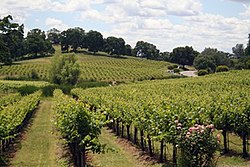
The Shenandoah Valley was once the principal viticultural region of California though not as well known as the Napa Valley AVA or Sonoma Valley AVA viticultural regions. With the discovery of gold, the area quickly became a mecca for those trying to make their fortune. In the process numerous wineries sprouted up, many of whose vineyards are still in use by wineries today. The decline of the California Gold Rush coupled with the onset of Prohibition devastated the wine-making region of Amador County. Today this area has been resurrected and is now home to over 40 different wineries. Amador County is known for its Zinfandel, but many other varietals are produced as well. Amador County has a high percentage of old Zinfandel vines. Some of the Zinfandel vineyards in this county are more than 125 years old[when?], including the original Grandpère vineyard, planted with Zinfandel before 1869 and believed to be the oldest Zinfandel vineyard in America. This 10-acre (40,000 m2) vineyard is home to some of the oldest Zinfandel vines on earth, with proof of their existence dating to 1869 when it was listed as a descriptor on a deed from the U.S. Geological Survey. A grant deed in Amador County records further proves their existence in 1869.[citation needed]
Politics, government, and policing
County Supervisors
The county is governed by a five-person elected Board of Supervisors and a County Administrator. The county seat is Jackson.
Policing
The unincorporated areas of Amador County are patrolled by the county sheriff's department, which also operates the county jail and protects the courts. Municipal police departments within the county are at Ione, Jackson, and Sutter Creek.
Voter registration statistics
| Population and registered voters | ||
|---|---|---|
| Total eligible population | 29,593 | |
| Registered voters | 25,954 | 87.7% |
| Democratic | 7,065 | 23.8% |
| Republican | 12,251 | 41.3% |
| Democratic–Republican spread | -5,186 | -16.5% |
| American Independent | 1,427 | 4.8% |
| Libertarian | 516 | 1.7% |
| Green | 109 | 0.3% |
| Peace and Freedom | 81 | 0.2% |
| Other | 128 | 0.4% |
| Unknown | 32 | 0.1% |
| No party preference | 4,353 | 14.7% |
Cities by population and voter registration
| City | Population | Registered voters | Democratic | Republican | D–R spread | Other | No party preference |
|---|---|---|---|---|---|---|---|
| Amador | 158 | 83.5% | 34.1% | 41.7% | -7.6% | 9.8% | 18.2% |
| Ione | 7,873 | 29.0% | 27.3% | 49.4% | -22.1% | 11.4% | 16.8% |
| Jackson | 4,626 | 55.7% | 32.3% | 42.6% | -10.3% | 11.2% | 18.4% |
| Plymouth | 1,055 | 49.4% | 30.9% | 38.8% | -7.9% | 13.2% | 22.5% |
| Sutter Creek | 2,497 | 68.4% | 35.9% | 41.9% | -6.0% | 9.6% | 16.7% |
Politics
| Year | Republican | Democratic | Third party(ies) | |||
|---|---|---|---|---|---|---|
| No. | % | No. | % | No. | % | |
| 1880 | 1,345 | 48.73% | 1,411 | 51.12% | 4 | 0.14% |
| 1884 | 1,317 | 47.72% | 1,358 | 49.20% | 85 | 3.08% |
| 1888 | 1,373 | 47.48% | 1,429 | 49.41% | 90 | 3.11% |
| 1892 | 1,125 | 43.04% | 1,255 | 48.01% | 234 | 8.95% |
| 1896 | 1,144 | 44.39% | 1,398 | 54.25% | 35 | 1.36% |
| 1900 | 1,384 | 52.64% | 1,209 | 45.99% | 36 | 1.37% |
| 1904 | 1,279 | 54.45% | 915 | 38.95% | 155 | 6.60% |
| 1908 | 1,035 | 51.88% | 874 | 43.81% | 86 | 4.31% |
| 1912 | 5 | 0.20% | 1,622 | 64.80% | 876 | 35.00% |
| 1916 | 1,209 | 38.53% | 1,766 | 56.28% | 163 | 5.19% |
| 1920 | 1,350 | 64.13% | 639 | 30.36% | 116 | 5.51% |
| 1924 | 719 | 38.93% | 316 | 17.11% | 812 | 43.96% |
| 1928 | 990 | 44.12% | 1,246 | 55.53% | 8 | 0.36% |
| 1932 | 822 | 25.34% | 2,367 | 72.97% | 55 | 1.70% |
| 1936 | 777 | 23.38% | 2,506 | 75.41% | 40 | 1.20% |
| 1940 | 1,372 | 32.85% | 2,762 | 66.14% | 42 | 1.01% |
| 1944 | 1,191 | 37.18% | 1,976 | 61.69% | 36 | 1.12% |
| 1948 | 1,578 | 38.84% | 2,334 | 57.45% | 151 | 3.72% |
| 1952 | 2,440 | 52.42% | 2,169 | 46.60% | 46 | 0.99% |
| 1956 | 2,126 | 49.16% | 2,181 | 50.43% | 18 | 0.42% |
| 1960 | 2,175 | 44.51% | 2,690 | 55.04% | 22 | 0.45% |
| 1964 | 1,682 | 32.99% | 3,410 | 66.89% | 6 | 0.12% |
| 1968 | 2,269 | 42.10% | 2,440 | 45.27% | 681 | 12.63% |
| 1972 | 3,533 | 53.40% | 2,705 | 40.89% | 378 | 5.71% |
| 1976 | 3,699 | 46.13% | 4,037 | 50.35% | 282 | 3.52% |
| 1980 | 5,401 | 55.85% | 3,191 | 33.00% | 1,078 | 11.15% |
| 1984 | 6,986 | 61.48% | 4,188 | 36.86% | 189 | 1.66% |
| 1988 | 6,893 | 55.87% | 5,197 | 42.12% | 248 | 2.01% |
| 1992 | 5,477 | 35.49% | 5,286 | 34.25% | 4,671 | 30.26% |
| 1996 | 6,870 | 47.54% | 5,868 | 40.60% | 1,714 | 11.86% |
| 2000 | 8,766 | 56.69% | 5,906 | 38.19% | 792 | 5.12% |
| 2004 | 11,107 | 62.08% | 6,541 | 36.56% | 243 | 1.36% |
| 2008 | 10,561 | 56.15% | 7,813 | 41.54% | 436 | 2.32% |
| 2012 | 10,281 | 58.25% | 6,830 | 38.70% | 538 | 3.05% |
| 2016 | 10,485 | 59.12% | 6,004 | 33.86% | 1,245 | 7.02% |
| 2020 | 13,585 | 60.91% | 8,153 | 36.55% | 566 | 2.54% |
| 2024 | 14,018 | 62.57% | 7,783 | 34.74% | 602 | 2.69% |
Crime
The following table includes the number of incidents reported and the rate per 1,000 persons for each type of offense.
| Population and crime rates | ||
|---|---|---|
| Population | 38,244 | |
| Violent crime | 107 | 2.80 |
| Homicide | 1 | 0.03 |
| Forcible rape | 10 | 0.26 |
| Robbery | 10 | 0.26 |
| Aggravated assault | 86 | 2.25 |
| Property crime | 537 | 14.04 |
| Burglary | 337 | 8.81 |
| Larceny-theft | 459 | 12.00 |
| Motor vehicle theft | 60 | 1.57 |
| Arson | 2 | 0.05 |
Cities by population and crime rates
| City | Population | Violent crimes | Violent crime rate per 1,000 persons | Property crimes | Property crime rate per 1,000 persons |
|---|---|---|---|---|---|
| Ione | 7,977 | 10 | 1.25 | 109 | 13.66 |
| Jackson | 4,677 | 38 | 8.12 | 136 | 29.08 |
| Sutter Creek | 2,513 | 7 | 2.79 | 62 | 24.67 |
Education
There is one school district in Amador County: Amador County Unified School District.
Due to the low population of the area, there are few schools with small class sizes. In total for public schools, there are two high schools, two junior high schools, and six elementary schools. These numbers are in addition to two independent study schools, one charter school, and one continuing education school for adults. There are no colleges or universities within the county's borders.
Transportation
Major highways
Public transportation
Amador Transit provides service in Jackson and nearby communities. Connections to Calaveras County and a daily commuter bus to/from Sacramento leave from the Sutter Hill Transit Center in Sutter Creek.
Airport
Amador County Airport is a general aviation airport located near Jackson.
Communities
Cities
- Amador City
- Ione
- Jackson (county seat)
- Plymouth
- Sutter Creek
Unincorporated communities
- Amador Pines
- Buckhorn
- Buena Vista
- Camanche North Shore
- Camanche Village
- Carbondale
- Clinton
- Drytown
- Enterprise
- Fiddletown
- Kirkwood
- Lockwood
- Martell
- New Chicago
- Pine Acres
- Pine Grove
- Pioneer
- Red Corral
- River Pines
- Roaring Camp
- Sutter Hill
- Volcano
In popular culture
"The Luck of Roaring Camp" is a short story by American author Bret Harte. It was first published in the August 1868 issue of the Overland Monthly and helped push Harte to international prominence. Harte lived in this area during his "Gold Rush" period, and possibly based the story in a mining camp on the Mokelumne River.
The Gold Rush rock music festival took place at Lake Amador on October 4, 1969. Performers included Ike & Tina Turner, Santana, Bo Diddley, Albert Collins, and Taj Mahal.
See also
- California State Library – California Room Collection.
- List of school districts in Amador County, California
- National Register of Historic Places listings in Amador County, California
- Amador High School
Notes
External links
38°26′N 120°40′W/38.44°N 120.66°W/ 38.44; -120.66