Bridgwater
In-game article clicks load inline without leaving the challenge.
Bridgwater is a historic market town and civil parish in Somerset, England. At the 2021 census, the parish had a population of 38,310, while the wider built-up area had a population of 47,860. Bridgwater is at the edge of the Somerset Levels, in level and well-wooded country. The town lies along both sides of the River Parrett; it has been a major inland port and trading centre since the industrial revolution. Most of its industrial bases still stand today. Its larger neighbour, Taunton, is linked to Bridgwater via a canal, the M5 motorway and the Bristol–Exeter railway line.
Historically, the town had a politically radical tendency. The Battle of Sedgemoor, where the Monmouth Rebellion was finally crushed in 1685, was fought nearby. Notable buildings include the Church of St Mary and Blake Museum, which was the birthplace of Admiral Blake in 1598. The town has an arts centre and plays host to the annual Bridgwater Guy Fawkes Carnival.
History
It is thought that the town was originally called Brigg, meaning quay. It has been argued that the name may instead come from the Old English brycg (gang plank) or Old Norse bryggja (quay), though this idea has been opposed on etymological grounds. In the Domesday Book the town is listed as Brugie, while Brugia was also used. After the Norman invasion the land was given to Walter of Douai, hence becoming known variously as Burgh-Walter, Brugg-Walter and Brigg-Walter, eventually corrupted to Bridgwater. An alternative version is that it derives from "Bridge of Walter" (i.e. Walter's Bridge).
Bridgwater is mentioned both in the Domesday Book and in the earlier Anglo-Saxon Chronicle dating from around 800, owing its origin as a trade centre to its position at the mouth of the chief river in Somerset. It was formerly part of the Hundred of North Petherton. In a legend of Alfred the Great, he burnt some cakes while hiding in the marshes of Athelney near Bridgwater, after the Danish invasion in 875, while in 878 the major engagement of the Battle of Cynwit may have been at nearby Cannington.
The Lord of the manor of Bridgwater was granted to William Briwere in 1201 by King John. Through Briwere's influence, the king had granted three charters in 1200 for the construction of Bridgwater Castle, for the creation of a borough, and for a market.
Bridgwater Castle was a substantial structure built in Old Red Sandstone, covering a site of 8 or 9 acres (32,000 or 36,000 m2). A tidal moat, up to 65 feet (20 m) wide in places, flowed about along the line of the modern thoroughfares of Fore Street and Castle Moat, and between Northgate and Chandos Street. The main entrance opposite the Cornhill was built with a pair of adjacent gates and drawbridges. In addition to a keep, located at the south-east corner of what is now King Square, documents show that the complex included a dungeon, chapel, stables and a bell tower. Built on the only raised ground in the town, the castle controlled the crossing of the town bridge. A portion of the castle wall and water gate can still be seen on West Quay, and the remains of a wall of a building that was probably built within the castle can be viewed in Queen Street. The foundations of the tower forming the north-east corner of the castle are buried beneath Homecastle House.
William Briwere also founded St John's hospital which, by the time of the Dissolution of the Monasteries under Henry VIII, was worth a substantial sum of more than 120 pounds. He was also responsible for starting the construction of the town's first stone bridge and went on to found the Bridgwater Friary.
Other charters were granted by Henry III in 1227 (confirmed in 1318, 1370, 1380). These gave Bridgwater a guild merchant which was important for the regulation of trade, allowing guild members to trade freely in the town, and to impose payments and restrictions upon others.
Incorporation and rebellions
During the 13th century Second Barons' War against Henry III, Bridgwater was held by Roger Mortimer, first Baron Mortimer against the King. Bridgwater's peasants under Nicholas Frampton took part in the Peasants' Revolt of 1381, sacking Sydenham House, murdering the local tax collectors and destroying the records.
Bridgwater was incorporated by charter of Edward IV (1468), confirmed in 1554, 1586, 1629 and 1684. Parliamentary representation as a borough constituency began in 1295 and continued until 1870, when the original borough constituency was disenfranchised for corruption; from 4 July 1870 the town was incorporated within the county constituency of West Somerset. When parliamentary seats were redistributed for the 1885 general election, a new county division of Bridgwater was created. A variety of markets were granted to the town during the Middle Ages including a Midsummer fair (on 24 June), one at the beginning of Lent was added in 1468, and one at Michaelmas. The importance of these markets and fairs for the sale of wool and wine, and later of cloth, declined after medieval times. The shipping trade of the port revived after the construction of the new dock in 1841, and corn and timber have been imported for centuries.
In the English Civil War the town and the castle were held by the Royalists under Colonel Edmund Wyndham, a personal acquaintance of the King. British history might have been very different had his wife, Lady (Crystabella) Wyndham, been a little more accurate with a musket shot that missed Oliver Cromwell but killed his aide de camp. Eventually, with many buildings destroyed in the town, the castle and its valuable contents were surrendered to the Parliamentarians on 21 July 1645. The castle itself was deliberately destroyed (slighted) the following year, while in 1651 Colonel Wyndham made arrangements for Charles II to flee to France following the Battle of Worcester.
Following the restoration of the monarchy, in 1663 the non-conformist Reverend John Norman, vicar from 1647 to 1660, was one of several 'religious fanatics' confined to their homes by Lord Stawell's militia. A large religious meeting house, thought to have been Presbyterian, was demolished and its furniture burned on the Cornhill in 1683. By 1688, matters had calmed down enough for a new chapel, Christ Church, to be founded in Dampiet Street, the congregation of which became Unitarian in 1815.
In the 1685 Monmouth Rebellion, the rebel Duke of Monmouth was proclaimed King on the Cornhill in Bridgwater and in other local towns. He eventually led his troops on a night-time attack on the King's position near Westonzoyland. Surprise was lost when a musket was accidentally discharged, and the Battle of Sedgemoor resulted in defeat for the Duke. He was later beheaded at the Tower of London, and nine locals were executed for treason.
Industral expansion
The Chandos Glass Cone was built in 1725 as a glasswork firing kiln by James Brydges, 1st Duke of Chandos as part of an industrial development. After a short period of use for glassmaking it was converted for the production of pottery, bricks and tiles, which continued until 1939. The majority of the brickwork cone was demolished in 1943. The bottom 2.4 metres (7 ft 10 in) has been preserved and scheduled as an ancient monument.
Bridgwater became the first town in Britain to petition the government to ban slavery, in 1785.
In 1896, the trade unionists of Bridgwater's brick and tile industry were involved a number of strikes. The Salisbury government sent troops to the town to clear the barricades by force after the reading of the Riot Act.
Twentieth century and after

A by-election in 1938 enabled the town to send a message to the government and Hitler, when an independent anti-appeasement candidate, journalist Vernon Bartlett was elected MP.
In World War II the Bridgwater and Taunton Canal formed part of the Taunton Stop Line, designed to prevent the advance of a German invasion. Pillboxes can still be seen along its length. The first bombs fell on Bridgwater on 24 August 1940, destroying houses on Old Taunton Road, and three men, three women and one child were killed. Later a prisoner of war camp was established at Colley Lane, holding Italian prisoners. During the preparations for the invasion of Europe, American troops were based in the town.
The first council estate to be built was in the 1930s at Kendale Road, followed by those at Bristol Road. The 1950s saw the start of a significant increase in post-war housebuilding, with council house estates being started at Sydenham and Rhode Lane and the former cooperative estate near Durleigh.
On 4 November 2011 West Quay alongside the River Parrett and 19 adjoining properties were evacuated after a 40 metres (130 ft) stretch of the retaining wall partially collapsed after heavy rain and flooding. The old hospital in Salmon Parade, which was built in 1813, closed in 2014 and has been replaced with a community hospital in Bower Lane. This provides a maternity unit and 30 inpatient beds. The old hospital site has been sold for development at a price of £1.6 million, and may be turned into a hotel.
Governance

As a result of the Local Government Act 1972, the Borough of Bridgwater was amalgamated into Sedgemoor District Council. Sedgemoor itself was merged into a new Somerset Council on 1 April 2023.
A new Bridgwater Town Council was created in 2003. It meets in Bridgwater Town Hall and has sixteen elected members representing six wards of the town: Bower (three), Eastover (two), Hamp (three), Quantock (three), Sydenham (three) and Victoria (two). The town council is responsible for matters allotments, bus shelters, play areas, street cleaning, cemeteries, certain parks, open spaces and heritage sites.
In 2018, Diogo Rodrigues became the first Portuguese national to be elected as a mayor in England, also becoming Bridgwater's youngest ever mayor.
The Bridgwater constituency has been represented in Parliament since 1295. After the voting age was lowered in January 1970, Susan Wallace became the first 18-year-old to vote in the UK, during the 1970 Bridgwater by-election that elected Tom King, who took the title Baron King of Bridgwater in 2001. At the 2010 General Election, Bridgwater became part of the new Bridgwater and West Somerset constituency. Following the completion of the 2023 review of Westminster constituencies, the seat was re-established as plain Bridgwater for the 2024 general election, primarily formed from the now abolished of Bridgwater and West Somerset seat but excluding the area comprising the former district of West Somerset. The current MP, elected in 2024, is Ashley Fox, a member of the Conservative Party.
Bridgwater was in the South West England constituency for elections to the European Parliament until the UK left the European Union in 2020.
Geography
Bridgwater is centred on an outcrop of marl in an area dominated by low-lying alluvial deposits. There are local deposits of gravels and sand. It is situated in a level and well-wooded area, on the edge of the Somerset Levels. To the north are the Mendip range and on the west the Quantock hills. The town lies along both sides of the River Parrett, 10 miles (16 km) from its mouth, which then flows to discharge into the Bridgwater Bay national nature reserve. It consists of large areas of mud flats, saltmarsh, sandflats and shingle ridges, some of which are vegetated. It has been designated as a Site of Special Scientific Interest since 1989, and is designated as a wetland of international importance under the Ramsar Convention. The risks to wildlife are highlighted in the local Oil Spill Contingency Plan.
Climate

Along with the rest of South West England, Bridgwater has a temperate climate which is generally wetter and milder than the rest of the country. The annual mean temperature is approximately 10 °C (50.0 °F). Seasonal temperature variation is less extreme than most of the United Kingdom because of the adjacent sea temperatures. The summer months of July and August are the warmest with mean daily maxima of approximately 21 °C (69.8 °F). In winter mean minimum temperatures of 1 or 2 °C (34 or 36 °F) are common. In the summer the Azores high pressure affects the south-west of England, however convective cloud sometimes forms inland, reducing the number of hours of sunshine. Annual sunshine rates are slightly less than the regional average of 1,600 hours. Most of the rainfall in the south-west is caused by Atlantic depressions or by convection. Most of the rainfall in autumn and winter is caused by the Atlantic depressions, which is when they are most active. In summer, a large proportion of the rainfall is caused by sun heating the ground leading to convection and to showers and thunderstorms. Average rainfall is around 700 mm (28 in). About 8–15 days of snowfall is typical. November to March have the highest mean wind speeds, and June to August have the lightest winds. The predominant wind direction is from the south-west.
| Climate data for Yeovilton, 20 m asl (1991–2020 normals), extremes 1964- | |||||||||||||
|---|---|---|---|---|---|---|---|---|---|---|---|---|---|
| Month | Jan | Feb | Mar | Apr | May | Jun | Jul | Aug | Sep | Oct | Nov | Dec | Year |
| Record high °C (°F) | 16.1 (61.0) | 17.7 (63.9) | 21.3 (70.3) | 25.4 (77.7) | 27.5 (81.5) | 33.6 (92.5) | 35.0 (95.0) | 34.9 (94.8) | 29.9 (85.8) | 26.5 (79.7) | 18.5 (65.3) | 16.0 (60.8) | 35.0 (95.0) |
| Mean daily maximum °C (°F) | 8.6 (47.5) | 9.0 (48.2) | 11.2 (52.2) | 13.9 (57.0) | 17.1 (62.8) | 19.9 (67.8) | 21.9 (71.4) | 21.6 (70.9) | 19.2 (66.6) | 15.3 (59.5) | 11.5 (52.7) | 9.0 (48.2) | 14.9 (58.8) |
| Daily mean °C (°F) | 5.3 (41.5) | 5.4 (41.7) | 7.1 (44.8) | 9.2 (48.6) | 12.3 (54.1) | 15.1 (59.2) | 17.1 (62.8) | 16.9 (62.4) | 14.6 (58.3) | 11.5 (52.7) | 8.0 (46.4) | 5.7 (42.3) | 10.7 (51.3) |
| Mean daily minimum °C (°F) | 2.0 (35.6) | 1.8 (35.2) | 3.0 (37.4) | 4.5 (40.1) | 7.4 (45.3) | 10.3 (50.5) | 12.2 (54.0) | 12.2 (54.0) | 10.0 (50.0) | 7.6 (45.7) | 4.4 (39.9) | 2.3 (36.1) | 6.5 (43.7) |
| Record low °C (°F) | −16.1 (3.0) | −12.2 (10.0) | −10.0 (14.0) | −6.4 (20.5) | −4.1 (24.6) | 0.0 (32.0) | 4.4 (39.9) | 2.9 (37.2) | −1.8 (28.8) | −4.8 (23.4) | −8.0 (17.6) | −14.2 (6.4) | −16.1 (3.0) |
| Average precipitation mm (inches) | 70.0 (2.76) | 50.9 (2.00) | 48.5 (1.91) | 51.5 (2.03) | 47.2 (1.86) | 57.1 (2.25) | 50.2 (1.98) | 60.7 (2.39) | 53.3 (2.10) | 80.9 (3.19) | 81.9 (3.22) | 77.4 (3.05) | 729.5 (28.72) |
| Average precipitation days (≥ 1.0 mm) | 12.2 | 10.4 | 10.0 | 10.0 | 9.2 | 8.7 | 8.3 | 9.8 | 9.1 | 12.0 | 13.2 | 12.9 | 125.8 |
| Mean monthly sunshine hours | 59.5 | 79.5 | 121.6 | 170.5 | 202.2 | 199.8 | 205.3 | 185.5 | 149.2 | 107.6 | 71.6 | 53.5 | 1,605.7 |
| Source 1: Met Office | |||||||||||||
| Source 2: Starlings Roost Weather |
Demography
The population of Bridgwater in 1841 was just 9,899, and by 1901 had risen to 14,900. At the 2021 census, Bridgwater civil parish had a population of 38,310 people in 16,543 households.
| Census | Population | Female | Male | Households | Source |
|---|---|---|---|---|---|
| 2011 | 35,886 | 18,232 | 17,654 | 15,363 | |
| 2021 | 38,310 | 18,920 | 19,390 | 16,543 |
The Office for National Statistics also define a Bridgwater 'Built-up Area', which includes contiguous urbanised areas outside the civil parish such as Dunwear and King's Drive in Bridgwater Without, and new build housing on the southern and western periphery of the town in North Petherton, Durleigh and Wembdon parishes (excluding the old villages and rural parts of those parishes); this area had a population of 47,860 in 2021. In 1971 the population in the 'Bridgwater Built-up Area' was 20,639 and by 2001 was given as 35,000.
Economy

As early as 1300, the port exported wheat, peas and beans to Ireland, France and Spain, and by 1400 was also exporting cloth from Somerset and the adjoining counties. By 1500 it was the largest port in Somerset, later becoming the fifth largest in England, until eclipsed by Bristol in the 18th century. In its heyday, imports included wine, grain, fish, hemp, coal and timber. Exports included wheat, wool, cloth, cement, bricks and tiles. Unlike Bristol, Bridgwater was never involved in the Atlantic slave trade and, in 1785, was the first town in Britain to petition the government to ban it.
The Bridgwater ship the Emanuel was one of three that took part in Martin Frobisher's 1577 search for the Northwest Passage. In 1828, 40 ships were registered in the port, averaging 60 tons each.
Industry
Bridgwater was the leading industrial town in Somerset and remains a major centre for manufacturing. A major manufacturing centre for clay tiles and bricks in the 19th century, including the famous "Bath brick", were exported through the port. In the 1890s there were a total of 16 brick and tile companies, and 24 million bricks per annum were exported during that decade alone. These industries are celebrated in the Somerset Brick and Tile Museum on East Quay. These industries collapsed in the aftermath of World War II due to the failure to introduce mechanisation, although the automated Chilton Tile Factory, which produced up to 5 million tiles each year, lasted until 1968.
During the 19th century, Castle House (originally named Portland Castle after Portland cement), reputedly the first domestic house in the UK to be built from concrete, was constructed in 1851 by John Board, a local brick and tile manufacturer. The building is now Grade II* listed, and in 2004 was featured in the BBC television programme Restoration.
In the 19th century, Bridgwater was also home to a number of iron foundries. George Hennet's Bridgwater Iron Works worked on bridges, railways and machinery for Brunel and Robert Stephenson. This location allowed the import by boat of raw materials from Wales and the dispatch of finished work to south Devon using the Bristol & Exeter Railway. The carriage workshops for the latter were on an adjacent site. The works passed to his son and then traded as Hennet, Spink & Else. Some of the ironwork was produced for the Royal Albert Bridge at Saltash, Cornwall. In 1873 it became the Bridgwater Engineering Company Limited but this failed in 1878. W&F Wills Ltd produced steam locomotives and fingerposts.
At the start of World War II, the government built a factory to manufacture high explosives at Puriton near Bridgwater. Called ROF Bridgwater, the plant became owned by BAE Systems and closed after decommissioning was completed in July 2008.
British Cellophane Ltd, a joint venture between La Cellophane SA and Courtaulds opened a major factory producing cellophane in Bridgwater in 1937. The factory produced Bailey bridges during World War II for the invasion of Europe. Bought by UCB Films (now Innovia Films) in 1996, the town suffered a blow in 2005 when Innovia closed the cellophane factory. At one time the factory employed around 3,000 people, although at the time of closure this had been reduced to just 250. However recovery has begun with the establishment of new businesses on the Express Park business park, including the relocation of and new enterprises Toolstation and Interpet as well as the Exel centre for the NHS Logistics Authority.
Bridgwater is now a major centre of industry in Somerset, with industries including the production of plastics, engine parts, industrial chemicals, and foods. Bowerings Animal Feed Mill is now the only industry still located at the docks. Being close to the M5 motorway and halfway between Bristol and Exeter, Bridgwater is also home to two major distribution centres, while retailer Argos has a regional distribution centre based at Huntworth. A new £100 m Regional Agricultural Business Centre opened in 2007, following construction which began in 2006.
As of 2021, a 616 acres (249 ha) commercial development campus named Gravity, targeting the low-carbon economy, is planned for the former ROF Bridgwater site 3.5 miles (5.6 km) north of Bridgwater.
Landmarks
River Parrett and its bridges
The River Parrett flows through the town. The town centre grew up on the west bank; the old part of the town on the east bank is known as Eastover. The Drove Bridge, which marks the current extent of the Port of Bridgwater, is the nearest to the mouth and the newest road bridge to cross the river. With a span of 184 feet (56 m), the bridge was constructed as part of the Bridgwater Northern Distributor road scheme (1992), and provides a navigable channel which is 66 feet (20 m) wide with 8.2 feet (2.5 m) headroom at normal spring high tides. Upstream of this is the retractable Telescopic Bridge, built in 1871 to the design of Francis Fox, the engineer for the Bristol & Exeter Railway. It carried a railway siding over the river to the docks, but had to be movable, to allow boats to proceed upriver. An 80-foot (24 m) section of railway track to the east of the bridge could be moved sideways, so that the main 127-foot (39 m) girders could be retracted, creating a navigable channel which was 78 feet (24 m) wide. It was manually operated for the first eight months, and then powered by a steam engine, reverting to manual operation in 1913, when the steam engine failed. The bridge was last opened in 1953, and the traverser section was demolished in 1974, but public outcry at the action resulted in the bridge being listed as a scheduled ancient monument, and the rest of the bridge was kept. It was later used as a road crossing, until the construction of the Chandos road bridge alongside it, and is now only used by pedestrians. Parts of the steam engine were moved to Westonzoyland Pumping Station Museum in 1977.
The next bridge is the Town Bridge. There has been a bridge here since the 13th century, when Bridgwater was granted a charter by King John. The present bridge was designed by R. C. Else and G. B. Laffan, and the 75-foot (23 m) cast iron structure was completed in 1883. It replaced an earlier bridge, which was the first cast iron bridge to be built in Somerset when it was completed in 1797. The stone abutments of that bridge were reused by the later bridge, which formed the only road crossing of the river in Bridgwater until 1958. Above the bridge there were two shoals, called The Coals and The Stones, which were a hazard to barge traffic on the river, and bargees had to choose carefully when to navigate the river, to ensure that there was sufficient water to carry them over these obstructions. In March 1958 a new reinforced concrete road bridge, the Blake Bridge, was opened as part of a bypass to take traffic away from the centre of Bridgwater. It now carries the A38 and A39 roads. On the southern edge of Bridgwater there is a bridge which carries the Bristol and Exeter Railway across the River Parrett. Isambard Kingdom Brunel designed a brick bridge, known as the Somerset Bridge, with a 100 feet (30 m) span but a rise of just 12 feet (3.7 m). Work started in 1838 and was completed in 1841. Brunel left the scaffold supporting the centre of the bridge in place as the foundations were still settling but was forced to remove it in 1843 to reopen the river for navigation. Brunel demolished the brick arch and had replaced it with a timber arch within six months without interrupting the traffic on the railway. This was in turn replaced in 1904 by a steel girder bridge.
Buildings

Bridgwater is home to the Somerset Brick and Tile Museum on East Quay is built on part of the former Barham Brothers site (brick and tile manufacturers between 1857 and 1965). It is a scheduled ancient monument and grade II* listed building.
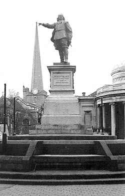
A house in Blake Street, largely restored, is believed to be the birthplace of Robert Blake in 1598, and is now the Blake Museum. It was built in the late 15th or early 16th century, and has been designated as a grade II* listed building. The Bridgwater Town Mill, originating in the Middle Ages is located at the end of Blake Street, next to the Blake Museum. A statue of Robert Blake, made by F. W. Pomeroy in 1898, is positioned in front of the Corn Exchange to face down Cornhill.
Castle House on Queen Street was built in 1851. It was one of the first buildings to make extensive use of concrete. It is also listed grade II*.
The public library in Binford place was designed by E Godfrey Page and dates from 1905. It is listed as grade II.
Sydenham Manor House, built in the early 16th century but rebuilt after 1613, is another grade II listed building. It is in the workers campus site for of Hinkley Point C nuclear power station off Bath Road.
Transport
Water


Bridgwater was part of the Port of Bristol until the Port of Bridgwater was created in 1348, covering 80 miles (130 km) of the Somerset coast line, from the Devon border to the mouth of the River Axe. Under an 1845 Act of Parliament the Port of Bridgwater extends from Brean Down to Hinkley Point in Bridgwater Bay, and includes parts of the River Parrett (to Bridgwater), River Brue and the River Axe.
The River Parrett was used to transport Hamstone from the quarry at Ham Hill in the medieval period. The main port on the river developed at Bridgwater where the lowest bridge was situated; the first bridge was built in 1200. Quays were built in 1424; another quay, the Langport slip, was built in 1488 upstream of the Town Bridge. A Customs House was sited at Bridgwater, on West Quay; and a dry dock, launching slips and a boat yard on East Quay. The river was navigable, with care, to Bridgwater Town Bridge by 400 to 500 tonnes (440 to 550 tons) vessels. By trans-shipping into barges at Bridgwater, goods could be carried further up the river as far as Langport and (via the River Yeo) to Ilchester. After 1827, it was also possible to transfer goods to Taunton via the Bridgwater and Taunton Canal at Huntworth. A floating harbour was constructed between 1837–1841 and the canal was extended to the harbour. The harbour area contained flour mills, timber yards and chandlers.
Shipping to Bridgwater expanded with the construction of Bridgwater Docks, and reached a peak between 1880 and 1885 with an average of 3,600 ships per year entering the port. Bridgwater also built some 167 ships; F J Carver and Son owned a small dry dock on East Quay and constructed the last ship to be built Irene which was launched in 1907.
The importance of shipping and the docks then started to decline as traffic transferred to railways and ships became too big for the port. The last commercial use of the docks was when coal imports ceased on 31 July 1971. Although ships no longer dock in the town of Bridgwater, 90,213 tonnes (99,443 tons) of cargo were handled within the port authority's area in 2006, most of which was stone products via the wharf at Dunball, mainly marine sand and gravels dredged in the Bristol Channel. Marine sand and gravel accounted for 55,754 tonnes (61,458 tons) of the total tonnage of 90,213 tonnes (99,443 tons) using the Port facilities in 2006, with salt products accounting for 21,170 tonnes (23,340 tons) in the same year.
Somerset Council acts as the Competent Harbour Authority for the port, and has provided pilotage services for all boats over 98 feet (30 m) using the river since 1998, when it took over the service from Trinity House. Pilotage is important because of the constant changes in the navigable channel resulting from the large tidal range, which can exceed 39 feet (11.9 m) on spring tides.
Railways

Bridgwater railway station is on St John Street. It is served by Great Western Railway services between Cardiff Central, Bristol Temple Meads and Taunton. Some services continue beyond Taunton to and from Exeter St Davids or even Penzance. There are also a small number of through trains to London Paddington via Bristol temple Meads and Bath Spa.
The Bristol & Exeter Railway opened on 14 June 1841 from Bristol to Bridgwater. The railway also opened a coach and wagon works in the town; the last of the buildings was in 2005 scheduled for demolition. Bridgwater railway station, designed by Isambard Kingdom Brunel is now a grade II listed building. An end to the unequal competition between rail and canal came in 1867 when the Bristol & Exeter Railway purchased the canal.
Another station, the terminus of a Somerset and Dorset Joint Railway branch line from Edington was opened in 1890 but closed in 1952. It was situated where Sainsbury's supermarket is today
Road

Bridgwater can be reached by the M5 motorway. Junction 23 is at Puriton to the north of the town, and junction n24 is at Huntworth to the south. The A38 road connects the town to Bristol and Taunton, the A39 road connects with Watchet, Glastonbury and Bath. The A372 road leaves the town through Westonzoyland and continues towards Yeovil.
Bridgwater bus station is on Watson's Lane near East Quay. Most local bus services are provided by First South West but staff and community services for Hinkley Point C are contracted to Somerset Passenger Solutions. Express services operated by is served twice daily by Berrys Coaches, Flixbus and National Express call at the bus station. Megabus Falcon services call at a bus stop by the motorway junction 24.
Education
The Bridgwater campus of Bridgwater and Taunton College is on Bath Road. The southern hub of the National College for Nuclear was launched at the Bridgwater campus in February 2018 as a scheme to provide trained staff for Hinkley Point C nuclear power station.
Bridgwater was selected as the first town in the South West, outside Bristol, to be selected for the UK government's Building Schools for the Future (BSF) initiative, which aimed to rebuild and renew nearly every secondary school in England. Within Bridgwater, BSF was to redevelop all of the four secondary schools and two special provision schools at an expected cost of around £100 million. This included the complete relocation and rebuilding of a new school combining both the Haygrove and Penrose Schools. In July 2010, several components of the Bridgwater BSF programme were cancelled and others were singled out for further review. Following a meeting with Education Secretary Michael Gove, Bridgwater MP Ian Liddell-Grainger announced that the fate of all six affected schools would be subject to review, including the ones that were cancelled.
Religious sites
Among several places of worship the chief is the Church of St Mary; this has a north porch and windows dating from the 14th century, besides a 170 feet (52 m) slender spire; but it has been much altered by restoration. It possesses a fine painted reredos, and has been designated by English Heritage as a grade I listed building.
There is also Christ Church Unitarian Chapel on Dampiet Street, built in 1688, it still retains many of its original features from 1688 and its remodeling in 1788. It has been designated by English Heritage as a grade II* listed building.
The Church of St John the Baptist in Blake Place was built by John More Capes and designed by John Brown in 1843. Elim Pentecostal Church on Church Street was a public house after being used as a church and is now a shop. There is a Salvation Army Citadel located in Moorland Road, on the Sydenham Estate and St Joseph's Roman Catholic in Binford Place.
Classes in Buddhism and meditation were held in the Quaker Meeting House on Friarn Street. In 2014 the building was put up for auction and purchased by local Muslims to become Bridgwater Islamic Centre.
Culture

Nearing Bridgwater on the M5 motorway it is possible to see the Willow Man sculpture, a 12 metres (39 ft) tall striding human figure constructed from willow. It was created by sculptor Serena de la Hey and is the largest known sculpture in willow, a traditional local material.
The Bridgwater Arts Centre was opened on 10 October 1946, the first community arts centre opened in the UK with financial assistance from the newly established Arts Council of England. It is situated in a Grade I listed building in the architecturally protected Georgian Castle Street, designed by Benjamin Holloway for the Duke of Chandos, and built over the site of the former castle. Holloway was also the architect of the Baroque Lions building on West Quay, constructed around 1730. Bridgwater Arts Centre was the venue for the first post-war meeting of the Congres Internationaux d'Architecture Moderne in 1947.
Somerset Film (then Somerset Film & Video) opened the Engine Room community media centre on the High Street in March 2003. The centre allows the public to drop in and use the computers and equipment to teach themselves how to edit video, design websites or screen films at open evenings.
Bridgwater Fair normally takes place in September, starting ons on the last Wednesday in September and running for four days. The fair takes place on St Matthew's Field, better known locally as the Fair Field. The fair is now a funfair, ranked as second largest in England after the Nottingham Goose Fair. It originated in 1249 as a horse and cattle fair, lasting for eight days near St Matthew's day (21 September), giving the venue its name. During the first weekend of July, the annual "Somerfest" arts festival is held in Bridgwater. The event includes an extensive programme of rock, jazz and classical music, dance, drama and visual arts with national and local participants.
Bridgwater carnival

The annual Bridgwater Guy Fawkes Carnival is the largest of the many West Country Carnivals. It attracts around 150,000 people from around the country and overseas. It is held on the Saturday nearest to 5 November (Guy Fawkes Night) although it was previously held on the first Thursday of November. The carnival parade follows a 2.5-mile (4.0 km) route over 2 to 3 hours and features more than 100 entries. Many of these are large vehicles (known as 'carts') up to 100 feet (30 m) long with sometimes as many as 22,000 lightbulbs. The carts carry dancers or people in static poses (known as 'tableaux') while other entrants ('masqueraders') walk around the route with the carts.
After the parade there is a firing of large fireworks ('squibs') in the street outside the town hall, an activity known as 'squibbing'.
Cultural references
Castle Street was used as a location in the 1963 film Tom Jones. Horror writer and film journalist Kim Newman was educated at Dr Morgan's school in Bridgwater, and set his 1999 experimental novel Life's Lottery in a fictionalised version of the town (Sedgwater). A sailor who had sailed "from Bridgwater with bricks" and found "There was lice in that bunk in Bridgwater" features in James Joyce's Ulysses (Chapter 16).
Twinning
Bridgwater is twinned with the following towns and cities:
- Uherské Hradiště, in the Czech Republic, since 1992
- La Ciotat in France, since 1957
- Homberg, Efze in Germany, since 1992
- Marsa in Malta, since 2006
- Priverno in Italy, since 2015
- Camacha in Madeira, Portugal, since 2019
Media
Local television news programmes are BBC Points West and ITV News West Country.
The BBC local radio station covering Bridgwater is BBC Radio Somerset. Sedgemoor FM is a local community radio station.
Sport and leisure
Bridgwater United F.C. are a football club based at Fairfax Park. The original version of the club was founded in 1898. The club currently plays in the Southern League Division One South and West. Rugby union club Bridgwater & Albion's ground is at College Way. It was founded in 1875. The Bridgwater Cricket Club plays at The Parks on Durleigh Road.
East Bridgwater Sports Centre has badminton courts, outside football pitches, squash courts and a fitness room.
Bridgwater had a series of swimming pools from 1890 until 2009. The first pool, on Old Taunton Road, was replaced by the Bridgwater Lido on Broadway, which was opened in 1960 by the Mayor, Alderman Mrs A. B. Potterton. The lido, which had three pools, a diving bay and paddling pool, was demolished in the late 1980s to make way for a supermarket and to fund the indoor Sedgemoor Splash swimming pool in Mount Street, which opened in 1991. The local council were unable to raise the funds needed to upgrade the pool so it was closed in 2009 and demolished. The site was redevloped for a supermarket.
Notable people


- John de Ponz (c.1248-c.1307), royal administrator and senior judge in Ireland and was sometimes known as "John of Bridgwater".
- Admiral Robert Blake (1598–1657), admiral and general at sea. His home is now the Blake Museum and contains details of his career and exhibits of local history and archaeology.
- William Diaper (1685–1717), clergyman and innovative poet.
- John Chubb (1746–1818), Bridgwater merchant and amateur artist, who painted portraits of his local contemporaries and street scenes. His work is kept at the Blake Museum, Bridgwater.
- Sir Davidge Gould (1758–1847), an admiral in the Royal Navy.
- Andrew Plimer (1763–1837), artist, whose brother was Nathaniel Plimer, also a painter of miniatures.
- Henry Phillpotts (1778–1869), Bishop of Exeter 1830–1869.
- Horace Smith (1779–1849), poet and novelist.
- John Clark (1785–1853) created the first automated text generator, The Eureka, exhibited in 1845.
- George Trevor (1809–1888), an English divine and writer on divinity matters.
- Fanny Talbot (1824–1917), philanthropist and friend of John Ruskin, who donated the first property to the National Trust.
- Margaret Sandford (1839–1903), a headmistress, author and an anti-suffragist [citation needed]
- James Sully (1842–1923), psychologist philosopher and writer.
- Alexander Scoles (1844–1920), Roman Catholic priest and architect of Catholic churches: he served as parish priest in Bridgwater and designed and built St Joseph's church, Binford Place.
- Annie Leigh Browne (1851–1936), educationist and suffragist.[citation needed]
- Thomazine Mary Lockyer (1852-1943), astronomer, suffragist, and Unitarian.
- Catherine Osler (1854–1924), social reformer and suffragist.
- Harry "Breaker" Morant (1864–1902), soldier in the Second Boer War and war criminal.
- Walter Farthing (1887–1954), politician, local Mayor, 1939/40, and MP 1945/1950.
- Sir Paul Dukes (1889–1967) educated at Caterham School, and went on to be an SIS agent.
- Jean Rees (1914–2004), artist and co-founder of the Bridgwater Arts Centre.
- John Biffen (1930–2007), politician, MP for North Shropshire from 1961 to 1997.
- Donald Crowhurst (1932–1969), who tried to fake a round-the-world solo yacht journey, set up his business in Bridgwater and was a borough councillor.
- Peter Haggett (1933-2025), academic geographer and professor at University of Bristol, went to Dr Morgan's Grammar School.
- Carol Lee Scott (1942-2017), entertainer, played the antagonist Grotbags.
- Chris Harris (1942–2014), English performer, director and writer who starred in Into the Labyrinth. He also starred in and directed the pantomime at the Theatre Royal, Bath from 2001.
- Neil Parish (born 1956), farmer and former politician, MP, 2010 to 2022.
Sports people

- Robert Dibble (1882–1963), rugby player, played for Bridgwater & Albion & Newport RFC and played 22 games for England.
- Tommy Woods (1883–1955), rugby player, played for Bridgwater & Albion & Rochdale Hornets.
- Elizabeth Ferris (1940–2012), diver, bronze medallist, 3 metre springboard, 1960 Summer Olympics.
- Charles Kent (1953–2005), rugby player, played for Bridgwater & Albion.
- Richard Harden (born 1965), cricketer, played 253 First-class cricket games.
- David Luckes (born 1969), field hockey goalkeeper, played 125 national games, brought up in Bridgwater.
- Richard Mantell (born 1981) and Simon Mantell (born 1984), brothers, played 115 & 212 games of field hockey for England.
- Matthew Villis (born 1984), footballer, played over 260 games including 101 for Weston-super-Mare.
See also
Notes
Attribution:
- This article incorporates text from a publication now in the public domain: Chisholm, Hugh, ed. (1911), "Bridgwater", Encyclopædia Britannica, vol. 4 (11th ed.), Cambridge University Press, p. 560
Further reading
- Baynes, T. S., ed. (1878), "Bridgewater", Encyclopædia Britannica, vol. 4 (9th ed.), New York: Charles Scribner's Sons, p. 342
External links
- (Sedgemoor District Council, archived)