Jajrud (river)
In-game article clicks load inline without leaving the challenge.
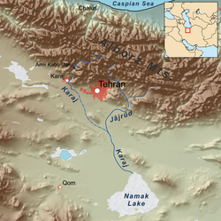
The Jajrud (Jājrūd) (Persian: جاجرود), also spelled as Jajrood, Djadjéroud or Djaderoud, is the largest river in Shemiranat County, Tehran province, Iran. Its sources are actually three different massifs of Southern Alborz mountain range and it flows mostly southwards until it is drained into the endorheic Namak Lake. Jajrud drainage basin covers an area of 698 square kilometres. There are two dams on Jajrud, Latyan Dam on upstream and Mamloo Dam on downstream, which are the main source of drinking water and hydropower for citizens of east and southeast of Tehran.
Central Alborz mountain range map
Number 5 on the lower side of map shows the Jajrud.
| Map of central Alborz | Peaks: | 1 Alam-Kuh |
| −25 to 500 m (−82 to 1,640 ft)500 to 1,500 m (1,600 to 4,900 ft)1,500 to 2,500 m (4,900 to 8,200 ft)2,500 to 3,500 m (8,200 to 11,500 ft)3,500 to 4,500 m (11,500 to 14,800 ft)4,500 to 5,610 m (14,760 to 18,410 ft) | 2 Azad Kuh | 3 Damavand |
| 4 Do Berar | 5 Do Khaharan | |
| 6 Ghal'eh Gardan | 7 Gorg | |
| 8 Kholeno | 9 Mehr Chal | |
| 10 Mishineh Marg | 11 Naz | |
| 12 Shah Alborz | 13 Sialan | |
| 14 Tochal | 15 Varavašt | |
| Rivers: | 0 | |
| 1 Alamut | 2 Chalus | |
| 3 Do Hezar | 4 Haraz | |
| 5 Jajrood | 6 Karaj | |
| 7 Kojoor | 8 Lar | |
| 9 Noor | 10 Sardab | |
| 11 Seh Hazar | 12 Shahrood | |
| Cities: | 1 Amol | |
| 2 Chalus | 3 Karaj | |
| Other: | D Dizin | |
| E Emamzadeh Hashem | K Kandovan Tunnel | |
| * Latyan Dam | ** Lar Dam |