Continental Portugal
In-game article clicks load inline without leaving the challenge.

Continental Portugal (Portuguese: Portugal continental, IPA: [puɾtuˈɣalkõtinẽˈtal]) or mainland Portugal comprises the bulk of the Portuguese Republic, namely that part on the Iberian Peninsula and so in continental Europe, having approximately 95% of the total population and 96.6% of the country's land. Mainland Portugal is therefore commonly called by residents of the Portuguese archipelagos of the Azores and Madeira the continent (Portuguese: o continente) in all respects including minor elements of combined governance from Lisbon, the country's capital. Before 1975, when the Portuguese territory also stretched to several now-independent states in Africa, the designation metropole (Portuguese: metrópole) was also used.
Context
The designation mainland Portugal is used to differentiate the continental territory of Portugal from its insular territory. The latter comprises the archipelagos of Madeira and Azores in the Atlantic Ocean. The Azores and Madeira are also commonly referred to as the autonomous regions (Portuguese: as regiões autónomas), insular Portugal (Portuguese: Portugal Insular) or, simply, the islands (Portuguese: as ilhas).
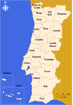
Continental Portugal is divided into 18 districts. Outside of these the islands of Madeira and the Azores are the Autonomous Regions of Portugal.
The European Nomenclature of Territorial Units for Statistics defines the geographic plurality of the mainland Portugal and the islands as the primary NUTS I territorial division (see administrative divisions of Portugal: NUTS for details).
While in modern Portugal the difference between European continental and total territory is minor (in terms of area), it mattered during the existence of the Portuguese Empire, when the distinction was more frequently made, such as in the colonisation of Brazil. Continental Portugal has an area of 89,015 square kilometres (34,369 mi2) or 96.6% of the Portuguese national territory (92,145 square kilometres (35,577 mi2)) and 10,248,477 inhabitants (or 95.34% of the total population of 10,749,635).
Districts
EU Statistical Regions (NUTS II)

| NUTS II | Districts (entirely or partly included) |
|---|---|
| Norte Alto MinhoCávadoAvePortoDouroTâmega e SousaAlto TâmegaTrás-os-Montes | Viana do Castelo, Braga, Porto, Aveiro (part), Guarda (part), Viseu (part), Vila Real, Bragança |
| Centro Beira BaixaBeiras e Serra da EstrelaRegião de AveiroRegião de CoimbraRegião de LeiriaViseu Dão Lafões | Castelo Branco, Guarda (majority) Aveiro (majority), Coimbra, Leiria (part), Viseu (majority) |
| Oeste e Vale do Tejo OesteMédio TejoLezíria do Tejo | Santarém, Leiria (part) |
| Greater Lisbon Greater Lisbon | Lisbon (majority) |
| Setúbal Peninsula Setúbal Peninsula | Setúbal (part) |
| Alentejo Alentejo LitoralAlentejo CentralAlto AlentejoBaixo Alentejo | Setúbal (part), Évora, Portalegre, Beja |
| Algarve Algarve | Faro |