Overland Route (Union Pacific Railroad)
In-game article clicks load inline without leaving the challenge.

The Overland Route was a train route operated jointly by the Union Pacific Railroad and the Central Pacific Railroad/Southern Pacific Railroad, between the eastern termini of Council Bluffs, Iowa, and Omaha, Nebraska, and the San Francisco Bay Area, over the grade of the first transcontinental railroad (also called the "Pacific Railroad") which opened on May 10, 1869. Passenger trains that operated over the line included the Overland Flyer, later renamed the Overland Limited, with its eastern terminal in Chicago.
The Overland Route remains a common name for the line from northern California to Chicago, now owned entirely by the Union Pacific. The route is now primarily used for freight, with a few portions used by Amtrak's California Zephyr passenger train.
History


The name harkens back to the Central Overland Route, a stagecoach line operated by the Overland Mail Company between Salt Lake City, Utah, and Virginia City, Nevada, from 1861 to 1866, when Wells Fargo & Company took over the stagecoach's operation. Wells Fargo ended this stagecoach service three years later.
While the Council Bluffs/Omaha to San Francisco "Pacific Railroad" grade was opened in 1869, the name “Overland” was not formally adopted for any daily extra-fare train over the route until almost two decades later. On November 13, 1887, the Union Pacific inaugurated service of its Overland Flyer between Omaha and Ogden, Utah, where passengers and through cars were transferred to the Southern Pacific, which had acquired the CPRR's operations on that line in 1885 under a 99-year lease. The UP changed its designation to the Overland Limited on November 17, 1895, and service continued as a daily train under that name in one form or another for almost seven decades. For the first dozen years that the SP met the UP's Overland trains, however, it dubbed its service the "Ogden Gateway Route"; its connecting westbound trains operated as the Pacific Express and eastbound trains as the Atlantic Express. The SP finally adopted the name the Overland Limited in 1899 for its portion of the run as well.
The original 1,911 miles (3,075 km) of the route from Omaha to San Francisco traversed some of the most desolate (as well some of the most picturesque) lands of the western two-thirds of the North American continent. While the trip originally took low-fare emigrant trains a full week (or more) to complete, by 1906 the electric lighted all-Pullman Overland Limited covered the route in just 56 hours.
E. H. Harriman bought the bankrupt Union Pacific in 1897; in 1901, he assumed control of the Central Pacific and Southern Pacific as well. The rebuilding of the Overland Route followed: hundreds of miles of double track, hundreds of miles of signals, and dozens of realignments to reduce grades, curvature, and perhaps distance. (The rebuilding actually started before the CP/SP acquisition—the map in the May 1969 issue of Trains shows the Howell-to-Bossler stretch realigned in 1899.)
By 1926, the UP route from Council Bluffs/Omaha to Ogden was continuous double track, except for the Aspen Tunnel (east of Evanston, Wyoming), which remained a bottleneck until 1949. The CP/SP portion of the route was also largely double-tracked during this period, with the completion of such projects as the 1909 Hood Realignment between Rocklin and Newcastle, double-tunneling along the Sierra Grade including at Cisco and the summit (Tunnel #41), and the 1924 agreement to share tracks across Nevada with the Western Pacific Railroad's Feather River Route.
Among the most important improvements to the original grade was the Lucin Cutoff, a new 102.9-mile (165.6 km) stretch from just west of Ogden to Lucin, a few miles east of the Nevada border. It included a 12-mile (19 km) trestle on wooden pilings across the Great Salt Lake. Opened in 1904, this line cut 43.8 miles (70.5 km) off the line, eliminated 3,919 degrees of curvature, and removed 1,515 feet (462 m) of climb from the route, thus decreasing the steepest SP grade east of Lucin from 90 feet per mile to 21.
But many other sections of the original 1860s grade were harder to improve on, notably over the Sierra Nevada between Colfax, California, and Reno, Nevada. The newer second track follows a better route here and there, but the original route changed little (except for the removal of the wooden snowsheds, or their replacement by nonflammable concrete ones) until the 1993 abandonment of the 6.7-mile section of the Track No. 1 crossing of the summit between Norden and Eder which includes the original 1,659-foot-long (506 m) Summit Tunnel (No. 6). Traffic was sent instead over the easier-to-maintain Track No. 2 and through the 10,322-foot-long (3,146 m) tunnel called “The Big Hole” (No. 41) which had been driven under Mt. Judah a mile south of the Pass when that portion of the line was double tracked in 1925. Aside from those modifications, the Sierra grade looks much the same to train passengers as it did when the line opened in 1868.
Connection to Chicago
From the start-up of the Overland Flyer in 1887 the Chicago and North Western Railway handled Overland Route trains between Chicago and Omaha. On October 30, 1955, passenger operations east of Omaha shifted to the Chicago, Milwaukee, St. Paul and Pacific Railroad (the "Milwaukee Road").
Demise

As intercity passenger rail travel began to decline after World War II and into the 1950s with the growth of the airline industry and development of the Interstate Highway System, the Overland route gradually lost its luster and service declined. After almost seven decades of continuous operation, the Overland Limited came to an end as a daily train on July 16, 1962, when the Interstate Commerce Commission approved termination of the service. While the train continued to run until Labor Day (with some additional holiday runs from Christmas to the New Year), the name “Overland” did not appear in the schedules of the UP or SP again after its last run on January 2, 1963. The only daily passenger train between Omaha and the San Francisco Bay area today is the California Zephyr, operated by Amtrak and mostly along a different, more scenic route. The Zephyr only uses the Overland Route in the states of California and Nevada, passing through Salt Lake City instead of Ogden and traveling via the Central Corridor to Denver instead of Cheyenne.[page needed] In 1996, the Union Pacific again acquired the Southern Pacific, resulting in the entire Chicago-Oakland line being owned by a single company.
Route description
Council Bluffs/Omaha to Ogden (via the Union Pacific)


Heading west from Council Bluffs/Omaha over the same wide-open plains of Nebraska's Platte River Valley that had been followed by so many wagon trains from the 1840s through the 1860s, Overland trains passed first through Fremont, Grand Island, and Kearney (196 miles from Omaha) where all the wagon trails from the Missouri River communities between Omaha and Kansas City had once converged. There the famous Fort Kearney had been built by the U.S. Army in 1858 to protect the Oregon–California Trail heading west, and from which, under the direction of Union Generals U.S. Grant and W.T. Sherman, soldiers had been dispatched to protect UP surveyors and construction crews from Indian attack as the road progressed across Nebraska towards Wyoming.
By the time travelers on the Overland Route crossed into Wyoming at Pine Bluffs, they had traveled some 470 miles (760 km) westward and risen in elevation above sea level from the 1,033 feet (315 m) at Omaha to 5,047 feet (1,538 m). The Rocky Mountains first came into passengers’ view 20 miles (32 km) further on at Hillsdale with the appearance of the dark crests of the Laramie Range. About 36 miles (58 km) further west the route reached Sherman, the highest point on the line at 8,013 feet (2,442 m), on a high and rugged upland with bold rock masses eroded into fantastic, picturesque shapes. The Ames Monument was constructed in 1882 to mark this highest point.
After passing through the towns of Laramie and Rawlins, the rough route crossed the Continental Divide at Creston, some 737 miles (1,186 km) west of Omaha. At Green River passengers were treated to views of two of the most spectacular rock formations in Wyoming—Man's Face directly southwest of the station, and Castle Rock just north of it. Six miles after crossing the Bear River at Evanston the route entered Utah, a land which would provide passengers with close-up views of some of the most unusual rock formations of the entire trip.
After passing Henefer where Brigham Young and his Mormon pioneers had turned southward in 1847 to cross the Wasatch Mountains into Emigration Cañon, perhaps the two most famous features on the Union Pacific's section of the Overland, Thousand Mile Tree and Devil's Slide, came into view on the west, and south sides of the track, respectively. Entering the Valley of the Great Salt Lake, the route soon reached Ogden, some 1,029 miles (1,656 km) from Omaha. Here the Union Pacific lines diverged to Los Angeles and the Pacific Northwest while the Southern Pacific (which acquired operational control of the CPRR's original Pacific route under lease in 1885) took charge of the “Overland Limited” and other trains on to San Francisco.
Ogden to San Francisco (via the Central Pacific/Southern Pacific)
When the route opened in 1869, trains reached the San Francisco Bay.
For the 35 years after the driving of the “Last Spike” at Promontory Summit in 1869, all trains traveling west of Ogden passed over the site of that seminal event as they made their way around the northern end of the Great Salt Lake. In November 1903, the SP opened the Lucin Cutoff, a 102.9-mile (165.6 km) stretch of track featuring a 12-mile (19 km) trestle built on pilings across the Great Salt Lake. Ten miles past Lucin, the “Overland” crossed into Nevada at Tecoma, the nearest railroad town to the silver, copper, and lead deposits discovered in the region in 1874.
Passing through other western Nevada mining centers and through Wells, an important supply point on the old Emigrant Trail, the line then followed the valley of the 300-mile (480 km) long Humboldt River. Devil's Peak, a perpendicular rock rising 500 feet (150 m) from the edge of the Humboldt River, dominated the canyon scenery at Palisade while the last major stop in Nevada was Reno with the Sierra Nevada mountains dominating the view ahead.
The next hundred miles of grade from Reno to Colfax, California, were by far the most challenging to build and provided the most impressive views of the whole route, although for much of that stretch passengers could see nothing as trains traveled through miles of tunnels and snowsheds. After passing Verdi, Nevada—which in November 1870 had become the site of the first train robbery on the Pacific coast—the Overland Route crossed into California and followed the Truckee River up a picturesque canyon to the town of Truckee on Donner Lake where the ill-fated George Donner party had been snowbound in the winter of 1846–7.
A serpentine climb around the east end of the lake and up Mt. Judah brought the Overland to the 1,659-foot-long (506 m) Summit Tunnel at 7,018 feet at Donner Pass and the start of a 105-mile (169 km) descent to Sacramento located just 35 feet (11 m) above sea level. Travel over this section could be quite treacherous in the winter as the Southern Pacific had to clear as much as 50 to 60 feet (15 to 18 m) of snowfall as well as ice from water dripping in the tunnels. The miles of showsheds needed to keep the line passable left the impression among passengers that they were “railroading in a tunnel” for much of the route. The wooden snowsheds sometimes caught fire from lightning strikes or embers from steam locomotives.
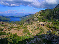
Still there were some extensive views available to passengers in the Sierras, the most famous of which[citation needed] was that from “Cape Horn” just above the town of Colfax where the grade was carved out of the side of a mountain, providing a panoramic view across Green Valley of the American River flowing in a canyon some 1,322 feet (403 m) below. This spot was so popular that for many years the Southern Pacific stopped the Overland and most other trains for a few minutes so that passengers could get off the train and take it all in from a special observation area.[citation needed]
When the route opened in 1869, trains reached the San Francisco Bay area from Sacramento via a 140-mile (230 km) line (built by the original Western Pacific Railroad) by way of Stockton over Altamont Pass, and on through Niles Canyon first to a pier at Alameda, and shortly thereafter to the nearby two-mile long Oakland Long Wharf (later called the "SP Mole") from which San Francisco was then accessed by ferry. In 1876, however, the CPRR acquired a line built by the California Pacific Railroad from Sacramento to Vallejo and in 1879 completed an extension of that road 17 miles (27 km) across the Suisun Marsh to Benicia. There the CPRR established a to carry its trains a little more than a mile across the Carquinez Strait to Port Costa from which they ran down the southern shoreline of the Strait and San Pablo Bay, and then along eastern side of the San Francisco Bay to the Oakland Long Wharf, thereby cutting about 50 miles (80 km) off the journey from Sacramento. After half a century of operation, the train ferry was replaced in October 1930 by a massive drawbridge built by the SP between Benicia and Martinez. It is still in use today.
- Magazine display advertisement for the "Overland Limited" c.1905
- The West portal of the "Summit Tunnel" (#6) at Donner Pass
- SP train ferry Contra Costa
Subdivisions
| vteGeneva Subdivision | ||||||
|---|---|---|---|---|---|---|
| Clinton Subdivision CPKC Railway CPKC Railway Clinton Railroad Bridge 136.7 mi220 km Mississippi River IowaIllinois BNSF Barstow Subdivision 127.7 mi205.5 km Union Grove 123.8 mi199.2 km Morrison 121 mi195 km Lyndon 118.6 mi190.9 km Round Grove 109.5 mi176.2 km Sterling Rock River Peoria Subdivision 104.3 mi167.9 km Nelson 97.9 mi157.6 km Dixon 92.9 mi149.5 km Nachusa 83.7 mi134.7 km Ashton 79 mi127 km Flagg Global III Intermodal Facility BNSF Aurora Subdivision 74.8 mi120.4 km Rochelle City of Rochelle Railroad 69.7 mi112.2 km Creston 63 mi101 km Malta 58.3 mi93.8 km DeKalb 55.4 mi89.2 km Cortland 50.6 mi81.4 km Maple Park 44.0 mi70.8 km Elburn UPW ends Elburn yard 40.8 mi65.7 km La Fox 35.5 mi57.1 km Geneva Fox River Freeport branch Elgin, Joliet & Eastern Rwy 29.7 mi47.8 km West Chicago 27.5 mi44.3 km Winfield Illinois Prairie Path 25.0 mi40.2 km Wheaton 23.8 mi38.3 km College Avenue 22.4 mi36 km Glen Ellyn DuPage River 19.9 mi32 km Lombard 17.8 mi28.6 km Villa Park Canadian National Railway Salt Creek 15.7 mi25.3 km Elmhurst 14.3 mi23 km Berkeley 12.7 mi20.4 km Bellwood Addison Creek Indiana Harbor Belt 11.3 mi18.2 km Melrose Park 10.5 mi16.9 km Maywood Des Plaines River 9.7 mi15.6 km River Forest Canadian National Railway Canadian National Railway 8.5 mi13.7 km Oak Park Harlem/Lake (CTA station) Chicago "L" Harlem/Lake Chicago "L" Green to Ashland/63rdand Cottage Grove Belt Railway of Chicago 4.8 mi7.7 km Keeler (employees only) 3.6 mi5.8 km Kedzie 3.0 mi4.8 km California Ave. coach yard Western Ave. CorridorCSX Blue Island Subdivision MDN MDW NCS Amtrak 2.6 mi4.2 km UPN UPNW MDN MDW NCSto Chicago Chicago Transit Authority Green Pink 0 Ogilvie TC | ||||||
| Clinton Subdivision | ||||||
| CPKC Railway | ||||||
| CPKC Railway | ||||||
| Clinton Railroad Bridge | 136.7 mi220 km | Mississippi River IowaIllinois | ||||
| 136.7 mi | ||||||
| 220 km | ||||||
| Iowa | ||||||
| Illinois | ||||||
| BNSF Barstow Subdivision | ||||||
| 127.7 mi205.5 km | Union Grove | |||||
| 127.7 mi | ||||||
| 205.5 km | ||||||
| 123.8 mi199.2 km | Morrison | |||||
| 123.8 mi | ||||||
| 199.2 km | ||||||
| 121 mi195 km | Lyndon | |||||
| 121 mi | ||||||
| 195 km | ||||||
| 118.6 mi190.9 km | Round Grove | |||||
| 118.6 mi | ||||||
| 190.9 km | ||||||
| 109.5 mi176.2 km | Sterling | |||||
| 109.5 mi | ||||||
| 176.2 km | ||||||
| Rock River | ||||||
| Peoria Subdivision | ||||||
| 104.3 mi167.9 km | Nelson | |||||
| 104.3 mi | ||||||
| 167.9 km | ||||||
| 97.9 mi157.6 km | Dixon | |||||
| 97.9 mi | ||||||
| 157.6 km | ||||||
| 92.9 mi149.5 km | Nachusa | |||||
| 92.9 mi | ||||||
| 149.5 km | ||||||
| 83.7 mi134.7 km | Ashton | |||||
| 83.7 mi | ||||||
| 134.7 km | ||||||
| 79 mi127 km | Flagg | |||||
| 79 mi | ||||||
| 127 km | ||||||
| Global III Intermodal Facility | ||||||
| BNSF Aurora Subdivision | ||||||
| 74.8 mi120.4 km | Rochelle | |||||
| 74.8 mi | ||||||
| 120.4 km | ||||||
| City of Rochelle Railroad | ||||||
| 69.7 mi112.2 km | Creston | |||||
| 69.7 mi | ||||||
| 112.2 km | ||||||
| 63 mi101 km | Malta | |||||
| 63 mi | ||||||
| 101 km | ||||||
| 58.3 mi93.8 km | DeKalb | |||||
| 58.3 mi | ||||||
| 93.8 km | ||||||
| 55.4 mi89.2 km | Cortland | |||||
| 55.4 mi | ||||||
| 89.2 km | ||||||
| 50.6 mi81.4 km | Maple Park | |||||
| 50.6 mi | ||||||
| 81.4 km | ||||||
| 44.0 mi70.8 km | Elburn | UPW ends | ||||
| 44.0 mi | ||||||
| 70.8 km | ||||||
| Elburn yard | ||||||
| 40.8 mi65.7 km | La Fox | |||||
| 40.8 mi | ||||||
| 65.7 km | ||||||
| 35.5 mi57.1 km | Geneva | |||||
| 35.5 mi | ||||||
| 57.1 km | ||||||
| Fox River | ||||||
| Freeport branch | ||||||
| Elgin, Joliet & Eastern Rwy | ||||||
| 29.7 mi47.8 km | West Chicago | |||||
| 29.7 mi | ||||||
| 47.8 km | ||||||
| 27.5 mi44.3 km | Winfield | |||||
| 27.5 mi | ||||||
| 44.3 km | ||||||
| Illinois Prairie Path | ||||||
| 25.0 mi40.2 km | Wheaton | |||||
| 25.0 mi | ||||||
| 40.2 km | ||||||
| 23.8 mi38.3 km | College Avenue | |||||
| 23.8 mi | ||||||
| 38.3 km | ||||||
| 22.4 mi36 km | Glen Ellyn | |||||
| 22.4 mi | ||||||
| 36 km | ||||||
| DuPage River | ||||||
| 19.9 mi32 km | Lombard | |||||
| 19.9 mi | ||||||
| 32 km | ||||||
| 17.8 mi28.6 km | Villa Park | |||||
| 17.8 mi | ||||||
| 28.6 km | ||||||
| Canadian National Railway | ||||||
| Salt Creek | ||||||
| 15.7 mi25.3 km | Elmhurst | |||||
| 15.7 mi | ||||||
| 25.3 km | ||||||
| 14.3 mi23 km | Berkeley | |||||
| 14.3 mi | ||||||
| 23 km | ||||||
| 12.7 mi20.4 km | Bellwood | |||||
| 12.7 mi | ||||||
| 20.4 km | ||||||
| Addison Creek | ||||||
| Indiana Harbor Belt | ||||||
| 11.3 mi18.2 km | Melrose Park | |||||
| 11.3 mi | ||||||
| 18.2 km | ||||||
| 10.5 mi16.9 km | Maywood | |||||
| 10.5 mi | ||||||
| 16.9 km | ||||||
| Des Plaines River | ||||||
| 9.7 mi15.6 km | River Forest | |||||
| 9.7 mi | ||||||
| 15.6 km | ||||||
| Canadian National Railway | Canadian National Railway | |||||
| 8.5 mi13.7 km | Oak Park | |||||
| 8.5 mi | ||||||
| 13.7 km | ||||||
| Harlem/Lake (CTA station) | Chicago "L" | Harlem/Lake | ||||
| Chicago "L" | Green to Ashland/63rdand Cottage Grove | |||||
| to Ashland/63rd | ||||||
| and Cottage Grove | ||||||
| Belt Railway of Chicago | ||||||
| 4.8 mi7.7 km | Keeler (employees only) | |||||
| 4.8 mi | ||||||
| 7.7 km | ||||||
| 3.6 mi5.8 km | Kedzie | |||||
| 3.6 mi | ||||||
| 5.8 km | ||||||
| 3.0 mi4.8 km | California Ave. coach yard | |||||
| 3.0 mi | ||||||
| 4.8 km | ||||||
| Western Ave. CorridorCSX Blue Island Subdivision | ||||||
| Western Ave. Corridor | ||||||
| CSX Blue Island Subdivision | ||||||
| MDN MDW NCS Amtrak | ||||||
| 2.6 mi4.2 km | ||||||
| 2.6 mi | ||||||
| 4.2 km | ||||||
| UPN UPNW | ||||||
| MDN MDW NCSto Chicago | ||||||
| MDN MDW NCS | ||||||
| to Chicago | ||||||
| Chicago Transit Authority | Green Pink | |||||
| 0 | Ogilvie TC | |||||
| vteClinton Subdivision | ||||||
|---|---|---|---|---|---|---|
| Geneva Subdivision Clinton CPKC Cedar Rapids Industrial Lead Cedar River Cedar Rapids & Iowa City Railway Cedar Rapids Industrial Lead Fairfax Iowa River Oskaloosa Subdivision Powerville Industrial Lead Marshalltown Freight Yard Mason City Subdivision Barilla Jewell Subdivision Boone Clinton Subdivision | ||||||
| Geneva Subdivision | ||||||
| Clinton | ||||||
| CPKC | ||||||
| Cedar Rapids Industrial Lead | ||||||
| Cedar River | ||||||
| Cedar Rapids & Iowa City Railway | ||||||
| Cedar Rapids Industrial Lead | ||||||
| Fairfax | ||||||
| Iowa River | ||||||
| Oskaloosa Subdivision | ||||||
| Powerville Industrial Lead | ||||||
| Marshalltown Freight Yard | ||||||
| Mason City Subdivision | ||||||
| Barilla | ||||||
| Jewell Subdivision | ||||||
| Boone | ||||||
| Clinton Subdivision | ||||||
| vteBoone Subdivision | ||||||
|---|---|---|---|---|---|---|
| Clinton Subdivision Boone and Scenic Valley Railroad Kate Shelley High Bridgeover the Des Moines River Tara Subdivision Jefferson Carroll Arion CN Omaha Subdivision Blair Subdivision | ||||||
| Clinton Subdivision | ||||||
| Boone and Scenic Valley Railroad | ||||||
| Kate Shelley High Bridgeover the Des Moines River | ||||||
| Kate Shelley High Bridge | ||||||
| over the Des Moines River | ||||||
| Tara Subdivision | ||||||
| Jefferson | ||||||
| Carroll | ||||||
| Arion | ||||||
| CN Omaha Subdivision | ||||||
| Blair Subdivision | ||||||
| vteBlair Subdivision | ||||||
|---|---|---|---|---|---|---|
| Boone Subdivision Missouri Valley Yard Omaha Subdivision Sioux City Subdivision Blair Bridgeover the Missouri River IowaNebraska Blair Fremont Omaha Subdivision BNSF Sioux City Subdivision Columbus Subdivision | ||||||
| Boone Subdivision | ||||||
| Missouri Valley Yard | ||||||
| Omaha Subdivision | ||||||
| Sioux City Subdivision | ||||||
| Blair Bridgeover the Missouri River IowaNebraska | ||||||
| Blair Bridge | ||||||
| over the Missouri River | ||||||
| Iowa | ||||||
| Nebraska | ||||||
| Blair | ||||||
| Fremont | ||||||
| Omaha Subdivision | ||||||
| BNSF Sioux City Subdivision | ||||||
| Columbus Subdivision | ||||||
| vteColumbus Subdivision | ||||||
|---|---|---|---|---|---|---|
| Omaha Subdivision Blair Subdivision BNSF Sioux City Subdivision North Bend BNSF Bellwood Subdivision Columbus Norfolk Subdivision Loup River Nebraska Central Railroad Nebraska Central Railroad Central City Kearny Subdivision | ||||||
| Omaha Subdivision | ||||||
| Blair Subdivision | ||||||
| BNSF Sioux City Subdivision | ||||||
| North Bend | ||||||
| BNSF Bellwood Subdivision | ||||||
| Columbus | ||||||
| Norfolk Subdivision | ||||||
| Loup River | ||||||
| Nebraska Central Railroad | ||||||
| Nebraska Central Railroad | ||||||
| Central City | ||||||
| Kearny Subdivision | ||||||
| vteKearney Subdivision | ||||||
|---|---|---|---|---|---|---|
| North Platte Terminal North Platte River Marysville Subdivision BNSF Ravenna Subdivision Nebraska Central Railroad Grand Island Columbus Subdivision | ||||||
| North Platte Terminal | ||||||
| North Platte River | ||||||
| Marysville Subdivision | ||||||
| BNSF Ravenna Subdivision | ||||||
| Nebraska Central Railroad | ||||||
| Grand Island | ||||||
| Columbus Subdivision | ||||||
| vteSidney Subdivision | ||||||
|---|---|---|---|---|---|---|
| Laramie Subdivision BNSF Front Range Subdivision Cheyenne Yard Egbert Yoder Subdivision WyomingNebraska Sidney and Lowe Railroad Sidney BNSF Angora Subdivision NebraskaColorado Julesburg Subdivision ColoradoNebraska Nebraska Public Power District Spur South Morrill Subdivision North Platte Terminal | ||||||
| Laramie Subdivision | ||||||
| BNSF Front Range Subdivision | ||||||
| Cheyenne Yard | ||||||
| Egbert | ||||||
| Yoder Subdivision | ||||||
| WyomingNebraska | ||||||
| Wyoming | ||||||
| Nebraska | ||||||
| Sidney and Lowe Railroad | ||||||
| Sidney | ||||||
| BNSF Angora Subdivision | ||||||
| NebraskaColorado | ||||||
| Nebraska | ||||||
| Colorado | ||||||
| Julesburg Subdivision | ||||||
| ColoradoNebraska | ||||||
| Colorado | ||||||
| Nebraska | ||||||
| Nebraska Public Power District Spur | ||||||
| South Morrill Subdivision | ||||||
| North Platte Terminal | ||||||
| vteLaramie Subdivision | ||||||
|---|---|---|---|---|---|---|
| Rawlins Subdivision Rawlins Sinclair Medicine Bow Rock River Laramie River Laramie Hermosa Tunnel Sherman Hillelev. 8,015 ft (2,443 m) Granite Canyon Quarry Borie Cutoff Greeley Subdivision Cheyenne Logistics Hub BNSF Front Range Subdivision Cheyenne Yard BNSF Front Range Subdivision Sidney Subdivision | ||||||
| Rawlins Subdivision | ||||||
| Rawlins | ||||||
| Sinclair | ||||||
| Medicine Bow | ||||||
| Rock River | ||||||
| Laramie River | ||||||
| Laramie | ||||||
| Hermosa Tunnel | ||||||
| Sherman Hillelev. 8,015 ft (2,443 m) | ||||||
| Sherman Hill | ||||||
| elev. 8,015 ft (2,443 m) | ||||||
| Granite Canyon Quarry | ||||||
| Borie Cutoff | ||||||
| Greeley Subdivision | ||||||
| Cheyenne Logistics Hub | ||||||
| BNSF Front Range Subdivision | ||||||
| Cheyenne Yard | ||||||
| BNSF Front Range Subdivision | ||||||
| Sidney Subdivision | ||||||
| vteRawlins Subdivision | ||||||
|---|---|---|---|---|---|---|
| Evanston Subdivision Green River Yard Rock Springs Wamsutter Continental Divide Crestonelev. 7,106 ft (2,166 m) Rawlins Laramie Subdivision | ||||||
| Evanston Subdivision | ||||||
| Green River Yard | ||||||
| Rock Springs | ||||||
| Wamsutter | ||||||
| Continental Divide Crestonelev. 7,106 ft (2,166 m) | ||||||
| Creston | ||||||
| elev. 7,106 ft (2,166 m) | ||||||
| Rawlins | ||||||
| Laramie Subdivision | ||||||
| vteEvanston Subdivision | ||||||
|---|---|---|---|---|---|---|
| Ogden Subdivision Lakeside Subdivision Salt Lake Subdivision Morgan UtahWyoming Evanston Altamontelev. 7,230 ft (2,200 m) Pocatello Subdivision Granger Genesis Green River Green River Yard Rawlins Subdivision | ||||||
| Ogden Subdivision | ||||||
| Lakeside Subdivision | ||||||
| Salt Lake Subdivision | ||||||
| Morgan | ||||||
| UtahWyoming | ||||||
| Utah | ||||||
| Wyoming | ||||||
| Evanston | ||||||
| Altamontelev. 7,230 ft (2,200 m) | ||||||
| Altamont | ||||||
| elev. 7,230 ft (2,200 m) | ||||||
| Pocatello Subdivision | ||||||
| Granger | ||||||
| Genesis | ||||||
| Green River | ||||||
| Green River Yard | ||||||
| Rawlins Subdivision | ||||||
| vteLakeside Subdivision | ||||||
|---|---|---|---|---|---|---|
| Evanston Subdivision Ogden Subdivision UTIP Industrial Lead Lucin Cutoffacross the Great Salt Lake trestle Promontory Point trestlecauseway trestle Lakeside Overland Route UtahNevada Tecoma Montello Nevada Northern Railway Cobre Valley Passelev. 6,075 ft (1,852 m) Pequop Holborn Wells Wells Branch Shafter Subdivision | ||||||
| Evanston Subdivision | ||||||
| Ogden Subdivision | ||||||
| UTIP Industrial Lead | ||||||
| Lucin Cutoffacross the Great Salt Lake | ||||||
| Lucin Cutoff | ||||||
| across the Great Salt Lake | ||||||
| trestle | ||||||
| Promontory Point | ||||||
| trestlecauseway | ||||||
| trestle | ||||||
| causeway | ||||||
| trestle | ||||||
| Lakeside | ||||||
| Overland Route | ||||||
| UtahNevada | ||||||
| Utah | ||||||
| Nevada | ||||||
| Tecoma | ||||||
| Montello | ||||||
| Nevada Northern Railway | ||||||
| Cobre | ||||||
| Valley Passelev. 6,075 ft (1,852 m) | ||||||
| Valley Pass | ||||||
| elev. 6,075 ft (1,852 m) | ||||||
| Pequop | ||||||
| Holborn | ||||||
| Wells | ||||||
| Wells Branch | ||||||
| Shafter Subdivision | ||||||
| vteShafter Subdivision | ||||||
|---|---|---|---|---|---|---|
| Lynndyl Subdivision Burmester Yard Morton Salt Cargill US Magnesium to Marblehead Aragonite Clive Bonneville Salt Flats Intrepid Potash Wendover UtahNevada Shafter Nevada Northern Railway Hogan's Tunnelelev. 5,901 ft (1,799 m) Spruce Wells Wells Branch Lakeside Subdivision Alazon Metropolis Branch Tulasco Hot Box Spur Deeth Halleck Elburz Tunnel No. 4 Tunnel No. 3 Osino rerouted c.1983 Elko station Elko Amtrak Elko Subdivision | ||||||
| Lynndyl Subdivision | ||||||
| Burmester Yard | ||||||
| Morton Salt | ||||||
| Cargill | ||||||
| US Magnesium | ||||||
| to Marblehead | ||||||
| Aragonite | ||||||
| Clive | ||||||
| Bonneville Salt Flats | ||||||
| Intrepid Potash | ||||||
| Wendover | ||||||
| UtahNevada | ||||||
| Utah | ||||||
| Nevada | ||||||
| Shafter | ||||||
| Nevada Northern Railway | ||||||
| Hogan's Tunnelelev. 5,901 ft (1,799 m) | ||||||
| Hogan's Tunnel | ||||||
| elev. 5,901 ft (1,799 m) | ||||||
| Spruce | ||||||
| Wells | ||||||
| Wells Branch | ||||||
| Lakeside Subdivision | ||||||
| Alazon | ||||||
| Metropolis Branch | ||||||
| Tulasco | ||||||
| Hot Box Spur | ||||||
| Deeth | ||||||
| Halleck | ||||||
| Elburz | ||||||
| Tunnel No. 4 | ||||||
| Tunnel No. 3 | ||||||
| Osino | ||||||
| rerouted c.1983 | ||||||
| Elko station | Elko Amtrak | |||||
| Elko Subdivision | ||||||
| vteElko Subdivision | ||||||
|---|---|---|---|---|---|---|
| Shafter Subdivision Shafter Subdivision rerouted c.1983 Elko station Elko Amtrak Elko (SP) Elko (WP) Tunnel No. 42 Carlin TunnelCarlin Tunnel Carlin Tunnel Carlin, NevadaCarlin, Nevada Carlin Tunnel No. 40 Palisade Tunnel No. 1 | Tunnel No. 39 Beowawe, Nevada Beowawe to Newmont Battle Mountain, Nevada Battle Mountain North Valmy Generating Station Golconda, Nevada Golconda Weso, NevadaWeso, Nevada Weso Winnemucca Subdivision Winnemucca Subdivision Nevada Subdivision Nevada Subdivision | ||||||
| Shafter Subdivision | Shafter Subdivision | |||||
| rerouted c.1983 | ||||||
| Elko station | Elko Amtrak | |||||
| Elko (SP) | ||||||
| Elko (WP) | ||||||
| Tunnel No. 42 | ||||||
| Carlin TunnelCarlin Tunnel | Carlin Tunnel | |||||
| Carlin, NevadaCarlin, Nevada | Carlin | |||||
| Tunnel No. 40 | ||||||
| Palisade | ||||||
| Tunnel No. 1 | Tunnel No. 39 | ||||||
| Beowawe, Nevada | Beowawe | |||||
| to Newmont | ||||||
| Battle Mountain, Nevada | Battle Mountain | |||||
| North Valmy Generating Station | ||||||
| Golconda, Nevada | Golconda | |||||
| Weso, NevadaWeso, Nevada | Weso | |||||
| Winnemucca Subdivision | Winnemucca Subdivision | |||||
| Nevada Subdivision | Nevada Subdivision | |||||
| vteNevada Subdivision | ||||||
|---|---|---|---|---|---|---|
| Elko Subdivision Weso, Nevada Weso Winnemucca Subdivision Winnemucca Amtrak Oreana Lovelock rerouted c.1902 Fallon branch Carson and Colorado Railway Hazen Fernley Modoc Subdivision Wadsworth rerouted c.1902 Innovation Park rerouted c.1902 Sparks Sparks Yard Roseville Subdivision | ||||||
| Elko Subdivision | ||||||
| Weso, Nevada | Weso | |||||
| Winnemucca Subdivision | ||||||
| Winnemucca Amtrak | ||||||
| Oreana | ||||||
| Lovelock | ||||||
| rerouted c.1902 | ||||||
| Fallon branch | ||||||
| Carson and Colorado Railway | ||||||
| Hazen | ||||||
| Fernley | ||||||
| Modoc Subdivision | ||||||
| Wadsworth | ||||||
| rerouted c.1902 | ||||||
| Innovation Park | ||||||
| rerouted c.1902 | ||||||
| Sparks | ||||||
| Sparks Yard | ||||||
| Roseville Subdivision | ||||||
| vteRoseville Subdivision | ||||||
|---|---|---|---|---|---|---|
| Nevada Subdivision Reno Industrial Lead Virginia & Truckee Reno Amtrak Lawton Truckee River Verdi Verdi Lumber Company 120th meridian west120th meridian west120th meridian west NevadaCalifornia Boca and Loyalton Railroad Hobart Southern Railway Truckee Amtrak Lake Tahoe Railway Tunnel No. 42 | No. 13 Snow Shed No. 47 original routemothballed 1993 Tunnel No. 41 Tunnel No. 41 Tunnel No. 41 10325 ft3147.1 m Tunnel No. 41 Tunnel No. 12 Tunnel No. 41 Snow Shed No. 41 Tunnel No. 41 Tunnel No. 11 Tunnel No. 41 Tunnel No. 10 Tunnel No. 41 Snow Shed No. 38 Tunnel No. 41 Tunnel No. 9 Tunnel No. 41 Snow Shed No. 37 Tunnel No. 41 Tunnel No. 8 Tunnel No. 41 Chinese Wall Tunnel No. 41 Nordenelev. 6,887 ft (2,099 m) Sugar Bowl Ski Resort gondola Tunnel No. 7 Tunnel No. 6 1659 ft505.7 m Snow Shed No. 25 Tunnel No. 4 | No. 39 Tunnel No. 3 | No. 38 Snow Shed No. 10 Tunnel No. 37 Tunnel No. 36 Tunnel No. 35 Nyack Tunnel No. 1 Tunnel No. 34 Tunnel No. 33 Long Ravine Trestleover the NCNG Colfax Amtrak Tunnel No. 32 Tunnel No. 31 Tunnel No. 30 Tunnel No. 29 1009 ft307.5 m Tunnel No. 28 3209 ft978.1 m Tunnel No. 27 Tunnel No. 26 150 ft45.7 m Tunnel No. 25 722 ft220.1 m Tunnel No. 24 301 ft91.7 m Tunnel No. 23 844 ft257.3 m Tunnel No. 22 Bowman Tunnel No. 21 1211 ft369.1 m Auburn Amtrak Auburn Ravine Bridge Tunnel No. 20 1248 ft380.4 m Tunnel No. 18 Newcastle Tunnel No. 17 Tunnel No. 16 Tunnel No. 15 1905 ft580.6 m Rocklin Amtrak Valley Subdivision Martinez Subdivision | ||||||
| Nevada Subdivision | ||||||
| Reno Industrial Lead | ||||||
| Virginia & Truckee | ||||||
| Reno Amtrak | ||||||
| Lawton | ||||||
| Truckee River | ||||||
| Verdi | ||||||
| Verdi Lumber Company | ||||||
| 120th meridian west120th meridian west120th meridian west | NevadaCalifornia | |||||
| Nevada | ||||||
| California | ||||||
| Boca and Loyalton Railroad | ||||||
| Hobart Southern Railway | ||||||
| Truckee Amtrak | ||||||
| Lake Tahoe Railway | ||||||
| Tunnel No. 42 | No. 13 | ||||||
| Snow Shed No. 47 | ||||||
| original routemothballed 1993 | ||||||
| original route | ||||||
| mothballed 1993 | ||||||
| Tunnel No. 41 | ||||||
| Tunnel No. 41 | Tunnel No. 41 | 10325 ft3147.1 m | ||||
| 10325 ft | ||||||
| 3147.1 m | ||||||
| Tunnel No. 41 | Tunnel No. 12 | |||||
| Tunnel No. 41 | Snow Shed No. 41 | |||||
| Tunnel No. 41 | Tunnel No. 11 | |||||
| Tunnel No. 41 | Tunnel No. 10 | |||||
| Tunnel No. 41 | Snow Shed No. 38 | |||||
| Tunnel No. 41 | Tunnel No. 9 | |||||
| Tunnel No. 41 | Snow Shed No. 37 | |||||
| Tunnel No. 41 | Tunnel No. 8 | |||||
| Tunnel No. 41 | Chinese Wall | |||||
| Tunnel No. 41 | Nordenelev. 6,887 ft (2,099 m) | |||||
| Norden | ||||||
| elev. 6,887 ft (2,099 m) | ||||||
| Sugar Bowl Ski Resort gondola | ||||||
| Tunnel No. 7 | ||||||
| Tunnel No. 6 | 1659 ft505.7 m | |||||
| 1659 ft | ||||||
| 505.7 m | ||||||
| Snow Shed No. 25 | ||||||
| Tunnel No. 4 | No. 39 | ||||||
| Tunnel No. 3 | No. 38 | ||||||
| Snow Shed No. 10 | ||||||
| Tunnel No. 37 | ||||||
| Tunnel No. 36 | ||||||
| Tunnel No. 35 | ||||||
| Nyack | ||||||
| Tunnel No. 1 | ||||||
| Tunnel No. 34 | ||||||
| Tunnel No. 33 | ||||||
| Long Ravine Trestleover the NCNG | ||||||
| Long Ravine Trestle | ||||||
| over the NCNG | ||||||
| Colfax Amtrak | ||||||
| Tunnel No. 32 | ||||||
| Tunnel No. 31 | ||||||
| Tunnel No. 30 | ||||||
| Tunnel No. 29 | 1009 ft307.5 m | |||||
| 1009 ft | ||||||
| 307.5 m | ||||||
| Tunnel No. 28 | 3209 ft978.1 m | |||||
| 3209 ft | ||||||
| 978.1 m | ||||||
| Tunnel No. 27 | ||||||
| Tunnel No. 26 | 150 ft45.7 m | |||||
| 150 ft | ||||||
| 45.7 m | ||||||
| Tunnel No. 25 | 722 ft220.1 m | |||||
| 722 ft | ||||||
| 220.1 m | ||||||
| Tunnel No. 24 | 301 ft91.7 m | |||||
| 301 ft | ||||||
| 91.7 m | ||||||
| Tunnel No. 23 | 844 ft257.3 m | |||||
| 844 ft | ||||||
| 257.3 m | ||||||
| Tunnel No. 22 | ||||||
| Bowman | ||||||
| Tunnel No. 21 | 1211 ft369.1 m | |||||
| 1211 ft | ||||||
| 369.1 m | ||||||
| Auburn Amtrak | ||||||
| Auburn Ravine Bridge | ||||||
| Tunnel No. 20 | 1248 ft380.4 m | |||||
| 1248 ft | ||||||
| 380.4 m | ||||||
| Tunnel No. 18 | ||||||
| Newcastle | ||||||
| Tunnel No. 17 | ||||||
| Tunnel No. 16 | ||||||
| Tunnel No. 15 | 1905 ft580.6 m | |||||
| 1905 ft | ||||||
| 580.6 m | ||||||
| Rocklin Amtrak | ||||||
| Valley Subdivision | ||||||
| Martinez Subdivision | ||||||
The modern incarnation of the Union Pacific Railroad has divided the Overland Route into the following subdivisions:
- Geneva Subdivision: Chicago, Illinois, to Clinton, Iowa
- Clinton Subdivision: Clinton to Boone
- Boone Subdivision: Boone to Missouri Valley, Iowa
- Blair Subdivision: Missouri Valley to Fremont, Nebraska (this subdivision bypasses Omaha, Nebraska)
- Omaha Subdivision: Missouri Valley to Fremont (via Omaha)
- Columbus Subdivision: Fremont to Grand Island
- Kearney Subdivision: Grand Island to North Platte
- Sidney Subdivision: North Platte to Cheyenne, Wyoming
- Laramie Subdivision: Cheyenne to Rawlins
- Rawlins Subdivision: Rawlins to Green River
- Evanston Subdivision: Green River to Ogden, Utah
- Lakeside Subdivision: Ogden to Alazon (line switchover near Wells, Nevada)
- Shafter Subdivision: Alazon to Elko
- Elko Subdivision: Elko to Weso (line switch near Winnemucca)
- Nevada Subdivision: Weso to Sparks
- Roseville Subdivision: Sparks to Roseville, California
- Martinez Subdivision: Roseville to Oakland, California
- Union Pacific Overland Route promotional image, c.1900
- Original profile of the CPRR/UPRR "Over-Land Route" of the Pacific Railroad
- "The Overland Route to the Road of a Thousand Wonders: The Route of the Union Pacific & Southern Pacific from Omaha to San Francisco - A Journey of Eighteen Hundred Miles Where Once the Bison & the Indian Reigned" Union and Southern Pacific Railroad Passenger Departments, 1908.
See also
- First transcontinental railroad—covers the construction of this rail line
- List of railroad crossings of the North American continental divide
- Overland Limited—a similarly named passenger train, operated by the Atchison, Topeka and Santa Fe Railway
Citations
General and cite deferences
- Beebe, Lucius Morris (1963). . Howell-North Books. OCLC .
- Scribbins, Jim (1970). The Hiawatha Story. Milwaukee, Wisconsin: Kalmbach Publishing Company. LCCN . OCLC .
- Solomon, Brian (2000). . Osceola, Wisconsin: MBI. ISBN 0-7603-0756-3.