Saskatchewan Highway 15
In-game article clicks load inline without leaving the challenge.
Highway 15 is an east–west provincial highway in the Canadian province of Saskatchewan. The highway runs from Highway 4, five kilometres (3mi) south of Rosetown, east to Highway 16, four kilometres (2mi) southeast of Bredenbury. It is an important truck route as it is a high clearance corridor that allows travel of over-dimension loads by shippers and commercial carriers. The highway is about 450 kilometres (280mi) long.
Highway 15 crosses the South Saskatchewan River via the Outlook Bridge, traverses the Touchwood Hills, and parallels the main line of the Canadian National Railway (CNR) between Nokomis and Melville. Some of the larger communities serviced by the highway include Outlook, Kenaston, Raymore, Ituna, and Melville.
Route description
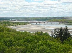

The western terminus for Highway 15 begins at Highway 4, about 5 kilometres (3.1mi) south of Rosetown. From there, it travels east towards the South Saskatchewan River providing access to Sovereign and Milden. The highway crosses the river via the Outlook Bridge. Once across the river, it turns north into the town of Outlook where it runs concurrently with the north bound McKenzie Street. At the intersection of McKenzie St and Saskatchewan Avenue, Highway 15 turns east and heads out of town. Continuing east, the highway comes to Broderick where it turns north-east for about 3 kilometres (1.9mi) then resumes its easterly routing to Kenaston and Highway 11. Highway 11, also known as the Louis Riel Trail, is a north–south, four-lane divided highway that connects Saskatchewan's two largest cities — Regina and Saskatoon. Highway 15 crosses Highway 11 and travels east for about 87 kilometres (54mi) to Nokomis and the north–south Highway 20. Along this stretch of 15, the highway provides access to Farrerdale, intersects with Highways 653 and 2 (the longest highway in Saskatchewan), and crosses three tributaries of Last Mountain Lake — Arm River, Lewis Creek, and Lanigan Creek.
The section of Highway 15 from Nokomos to Melville is paralleled by the main line of the Canadian National Railway and runs generally south-east. At Nokomis, Highways 15 and 20 head south running concurrently for 9.7 kilometres (6.0mi) to Hatfield. Highway 20 continues south while 15 heads east for 33 kilometres (21mi) en route to Raymore and Highway 6. Semans, at the intersection of Highway 641, is the only community on 15 between Highways 20 and 6. At Raymore, 15 and 6 share a short 2.6-kilometre (1.6mi) long south bound concurrency. Highway 6 continues south while 15 branches off and heads south-east towards the town of Ituna. From the junction of 15 and 6 to Ituna, Highway 15 provides access to Quinton, Punnichy, Touchwood Hills Post Provincial Park, Muskowekwan First Nation, Lestock, Leross, Kelliher, and Jasmine. It intersects with Highways 640, 639, 35, 52, and 310. Heading into Ituna, 15 has a 4.6-kilometre (2.9mi) long concurrency with 310. Through Ituna, 15 and 310 follow Main St to 1st Ave NE, at which point 15 splits off south-east following 1st Ave NE out of town. It continues its south-easterly routing towards Melville. The segment of Highway 15 from Ituna to Highway 47 on the western side of Melville is 54 kilometres (34mi) long. Along this stretch, Highway 15 provides access to Ituna Airport, Hubbard, Goodeve, Fenwood, and Birmingham.
As Highway 15 leaves the intersection with Highway 47, it enters the city of Melville and runs concurrently with 3rd Ave W, Dielschneider Rd, 1st Ave W, and 1st Ave E. From the eastern side of Melville, Highway 15 exits the city and travels east to its eastern terminus at Highway 16 between Bredenbury and Churchbridge. Along the way, it intersects Highways 605, 9, and 637. From Highway 9 east to 16, Highway 15 is an 8-tonne road and banned for heavy trucks.
Maintenance and upgrades

- Highway 15 originally crossed the South Saskatchewan River via the "old" Outlook Bridge that was built in 1936. In 1998 a "new" Outlook Bridge was constructed and the highway was rerouted to the south a short distance to cross the new bridge.
- In 2008, roughly 2km (1.2mi) of micro-surfacing was done to Highway 15 from about 4km (2.5mi) west of the Conquest Access Road westward.
- In 2023, a two-year highway improvement project was begun on Highway 15 east of Kenaston between Highways 11 and 2. The project, valued at $22.7 million, included the construction of a subgrade, widening and resurfacing of the highway, and culvert replacements. The work included "22 km of highway that started 15 km east of the junction with Highway 11 to about 20 km west of the junction with Highway 2".
- In 2024, culverts were replaced on Highway 15 near Broderick at a cost of more than $1.2 million.
Major intersections
From west to east:
| Rural municipality | Location | km | mi | Destinations | Notes |
|---|---|---|---|---|---|
| St. Andrews No.287 | | 0.0 | 0.0 | Highway 4– Rosetown, The Battlefords, Swift Current | Highway15 western terminus |
| Sovereign | 17.8 | 11.1 | Highway 664– Zealandia, Forgan | ||
| Milden No.286 | Milden | 34.5 | 21.4 | Highway 655 north | |
| | 36.1 | 22.4 | Highway 42 east– Dinsmore | ||
| Fertile Valley No.285 | | 44.3 | 27.5 | Bounty access road | |
| | 47.5 | 29.5 | Highway 654 south | ||
| | 52.4 | 32.6 | Conquest access road | ||
| | 60.5 | 37.6 | Highway 45 north– Delisle | West end of Highway45 concurrency | |
| | 62.1 | 38.6 | Highway 45 south– Macrorie, Gardiner Dam, Lucky Lake | East end of Highway45 concurrency | |
| ↑ / ↓ | | 64.1 | 39.8 | Outlook Bridge crosses the South Saskatchewan River | |
| Rudy No.284 | Outlook | 66.8 | 41.5 | Saskatchewan Avenue / McKenzie Street | Highway15 branches east |
| Broderick | 76.9 | 47.8 | Highway 764 north– Hanley | ||
| | 85.4 | 53.1 | Highway 219 (Chief Whitecap Trail)– Saskatoon, Gardiner Dam | ||
| Rosedale No.283 | | 100.0 | 62.1 | Highway 19 south– Hawarden, Elbow | |
| McCraney No.282 | Kenaston | 122.7 | 76.2 | Highway 11 (Louis Riel Trail)– Saskatoon, Regina | |
| | 144.8 | 90.0 | Highway 653 south– Davidson | ||
| Wood Creek No.281 | | 179.0 | 111.2 | Highway 2 (Veterans Memorial Highway)– Prince Albert, Watrous, Moose Jaw | |
| Wreford No.280 | Nokomis | 209.9 | 130.4 | Highway 20 north to Highway 744– Lanigan, Humboldt | West end of Highway20 concurrency |
| | 219.6 | 136.5 | Highway 20 south– Lumsden | East end of Highway20 concurrency | |
| Mount Hope No.279 | | 239.1 | 148.6 | Highway 641 south– Semans | |
| Raymore | 252.2 | 156.7 | Highway 6/ CanAm Highway north– Melfort | West end of Highway6 concurrency | |
| | 254.8 | 158.3 | Highway 6/ CanAm Highway south– Regina | East end of Highway6 concurrency | |
| Punnichy | 271.9 | 169.0 | Highway 640 south– Cupar | West end of Highway640 concurrency | |
| | 273.8 | 170.1 | Highway 640 north– Wynyard | East end of Highway640 concurrency | |
| Kellross No.247 | Lestock | 296.0 | 183.9 | Highway 639– Wishart, Dysart | |
| | 306.4 | 190.4 | Highway 35– Wadena, Fort Qu'Appelle | East of Leross; west of Kelliher | |
| Ituna Bon Accord No.246 | | 332.9 | 206.9 | Highway 52 east/ Highway 310 north– Yorkton, Foam Lake | West end of Highway310 concurrency; Highway52 western terminus |
| Ituna | 337.4 | 209.7 | Highway 310 south– Balcarres | East end of Highway310 concurrency | |
| Tullymet No.216 | No major junctions | ||||
| Stanley No.215 | | 357.4 | 222.1 | Highway 617 north– Sheho | West end of Highway617 concurrency |
| Goodeve | 363.1 | 225.6 | Highway 617 south– Lemberg | East end of Highway617 concurrency | |
| City of Melville | 391.4 | 243.2 | Highway 10/ Highway 47– Yorkton, Regina, Springside, Grenfell | ||
| 392.7 | 244.0 | Queen Street | To Highway 47 north | ||
| Cana No.214 | | 405.4 | 251.9 | Highway 605 north– Grayson | |
| | 416.8 | 259.0 | Highway 9– Yorkton, Whitewood | ||
| Saltcoats No.213 | | 433.1 | 269.1 | Highway 629– Saltcoats, Atwater | |
| | 446.1 | 277.2 | Highway 637– Bredenbury, Esterhazy | ||
| Saltcoats No.213–Churchbridge No.211 line | | 449.6 | 279.4 | Highway16 (TCH/YH)– Bredenbury, Yorkton, Churchbridge, Winnipeg | |
| 1.000mi = 1.609km; 1.000km = 0.621mi Concurrency terminus |
See also
External links
Media related toSaskatchewan Highway 15at Wikimedia Commons