TS postcode area
In-game article clicks load inline without leaving the challenge.
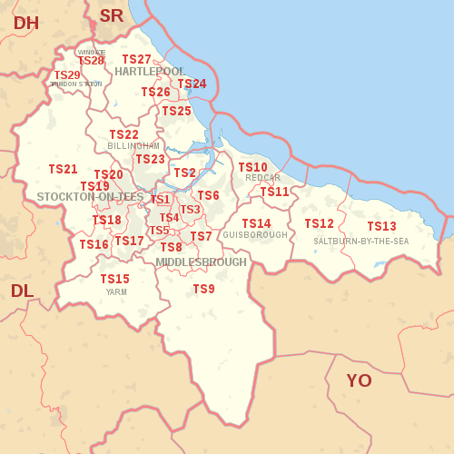
The TS postcode area, also known as the Cleveland postcode area, is a group of 29 postcode districts in northern England for ten post towns. These cover north-east North Yorkshire (post towns Middlesbrough, Redcar, Saltburn-by-the-Sea, Guisborough and Yarm) and south-east County Durham (post towns Stockton-on-Tees, Hartlepool, Billingham, Wingate and Trimdon Station).
The letters in the postcode are derived from Teesside, giving rise also to the unofficial label Teesside postcode area.
Mail for the TS postcode area is processed at Tyneside Mail Centre in Gateshead, along with mail for the DH, DL, NE and SR postcode areas.
Coverage
The approximate coverage of the postcode districts:
| Postcode district | Post town | Coverage | Local authority area(s) |
|---|---|---|---|
| TS1 | MIDDLESBROUGH | Middlesbrough (town centre) | Middlesbrough |
| TS2 | MIDDLESBROUGH | St Hilda's, Port Clarence | Middlesbrough, Stockton-on-Tees |
| TS3 | MIDDLESBROUGH | Middlesbrough's east: Brambles Farm, Thorntree, Park End, North Ormesby, Berwick Hills | Middlesbrough |
| TS4 | MIDDLESBROUGH | Middlesbrough's centre-east: Beechwood, Easterside, Grove Hill, Longlands, Prissick, Saltersgill | Middlesbrough |
| TS5 | MIDDLESBROUGH | Middlesbrough's west: Acklam, Ayresome, Brookfield, Linthorpe, Whinney Banks | Middlesbrough |
| TS6 | MIDDLESBROUGH | Eston, Grangetown, Normanby, Teesville, South Bank | Redcar and Cleveland |
| TS7 | MIDDLESBROUGH | Middlesbrough's south-east: Marton, Nunthorpe, Ormesby | Middlesbrough, Redcar and Cleveland |
| TS8 | MIDDLESBROUGH | Middlesbrough's south-west (Coulby Newham, Marton, Hemlington), Stainton, Thornton & Maltby | Middlesbrough, Stockton-on-Tees |
| TS9 | MIDDLESBROUGH | Great Ayton, Stokesley | North Yorkshire |
| TS10 | REDCAR | Redcar (town centre), Coatham, Dormanstown, Kirkleatham, Warrenby | Redcar and Cleveland |
| TS11 | REDCAR | Marske, New Marske | Redcar and Cleveland |
| TS12 | SALTBURN-BY-THE-SEA | Saltburn, Brotton, Skelton | Redcar and Cleveland |
| TS13 | SALTBURN-BY-THE-SEA | Loftus, Skinningrove, Staithes | Redcar and Cleveland, North Yorkshire |
| TS14 | GUISBOROUGH | Guisborough | Redcar and Cleveland |
| TS15 | YARM | Yarm, Kirklevington, Hutton Rudby | Stockton-on-Tees |
| TS16 | STOCKTON-ON-TEES | Aislaby, Eaglescliffe, Egglescliffe, Preston-on-Tees (village), Urlay Nook | Stockton-on-Tees |
| TS17 | STOCKTON-ON-TEES | Ingleby Barwick, Thornaby | Stockton-on-Tees, Middlesbrough |
| TS18 | STOCKTON-ON-TEES | Stockton's east: town centre, Hartburn, Grangefield, Oxbridge, Portrack | Stockton-on-Tees, County Durham |
| TS19 | STOCKTON-ON-TEES | Stockton's west: Bishopsgarth, Elm Tree Farm, Fairfield, Hardwick, Newtown, Roseworth | Stockton-on-Tees |
| TS20 | STOCKTON-ON-TEES | Norton | Stockton-on-Tees |
| TS21 | STOCKTON-ON-TEES | Bishopton, Carlton, Long Newton, Redmarshall, Stillington, Thorpe Thewles, Sedgefield | Stockton-on-Tees, County Durham |
| TS22 | BILLINGHAM | Billingham (West), Wolviston, Wynyard | Stockton-on-Tees |
| TS23 | BILLINGHAM | Billingham (East) | Stockton-on-Tees |
| TS24 | HARTLEPOOL | Hartlepool (town centre, marina, Stranton), the Headland | Hartlepool |
| TS25 | HARTLEPOOL | Greatham, Owton, Rift House, Seaton Carew, | Hartlepool |
| TS26 | HARTLEPOOL | Throston, West Park | Hartlepool |
| TS27 | HARTLEPOOL | Blackhall Rocks, Blackhall Colliery, Castle Eden, Hesleden, High Hesleden, Hutton Henry | Hartlepool, County Durham |
| TS28 | WINGATE | Wingate, Station Town | County Durham |
| TS29 | TRIMDON STATION | Trimdon | County Durham |
Map