Territorial evolution of the United States
In-game article clicks load inline without leaving the challenge.

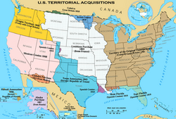
The United States of America was formed after thirteen British colonies in North America declared independence from the British Empire on July 4, 1776. In the Lee Resolution, passed by the Second Continental Congress two days prior, the colonies resolved that they were free and independent states. The union was formalized in the Articles of Confederation, which came into force on March 1, 1781, after being ratified by all 13 states. Their independence was recognized by Great Britain in the Treaty of Paris of 1783, which concluded the American Revolutionary War. This effectively doubled the size of the colonies, now able to stretch west past the Proclamation Line to the Mississippi River. This land was organized into territories and then states, though there remained some conflict with the sea-to-sea grants claimed by some of the original colonies. In time, these grants were ceded to the federal government.
The first great expansion of the country came with the Louisiana Purchase of 1803, which doubled the country's territory, although the southeastern border with Spanish Florida was the subject of much dispute until it and Spanish claims to the Oregon Country were ceded to the US in 1821. The Oregon Country gave the United States access to the Pacific Ocean, though it was shared for a time with the United Kingdom. The annexation of the Republic of Texas in 1845 led directly to the Mexican–American War, after which the victorious United States obtained the northern half of Mexico's territory, including what was quickly made the state of California.
As the development of the country moved west, however, the question of slavery became more important, with vigorous debate over whether the new territories would allow slavery and events such as the Missouri Compromise and Bleeding Kansas. This came to a head in 1860 and 1861, when the governments of the southern states proclaimed their secession from the country and formed the Confederate States of America. The American Civil War led to the defeat of the Confederacy in 1865 and the eventual readmission of the states to the United States Congress. The cultural endeavor and pursuit of manifest destiny provided a strong impetus for westward expansion in the 19th century.
The United States began expanding beyond North America in 1856 with the passage of the Guano Islands Act, causing many small and uninhabited, but economically important, islands in the Caribbean Sea and the Pacific Ocean to be claimed. Most of these claims were eventually abandoned, largely because of competing claims from other countries. The Pacific expansion culminated in the annexation of Hawaii in 1898, after the overthrow of its government five years previously. Alaska, the last major acquisition in North America, was purchased from Russia in 1867. Support for the independence of Cuba from the Spanish Empire, and the sinking of the USS Maine, led to the Spanish–American War in 1898, in which the United States gained Puerto Rico, Guam, and the Philippines, and occupied Cuba for several years. American Samoa was acquired by the United States in 1900 after the end of the Second Samoan Civil War. The United States purchased the U.S. Virgin Islands from Denmark in 1917.
Following the war, many islands were entrusted to the U.S. by the United Nations, and while the Northern Mariana Islands became a U.S. territory, the Marshall Islands, Federated States of Micronesia, and Palau emerged from the trust territory as independent nations. The last major international change was the acquisition in 1904, and return to Panama in 1979, of the Panama Canal Zone, an unincorporated US territory which controlled the Panama Canal. The final cession of formal control over the region was made to Panama in 1999.
States have generally retained their initial borders once established. Only three states (Kentucky, Maine, and West Virginia) have been created directly from area belonging to another state (although at the time of admission, Vermont agreed to a monetary payment for New York to relinquish its claim); all of the other states were created from federal territories or from acquisitions. Four states (Louisiana, Missouri, Nevada, and Pennsylvania) have expanded substantially by acquiring additional federal territory after their initial admission to the Union. In 1912, Arizona was the last state established in the contiguous United States, commonly called the "lower 48". In 1959, Hawaii was the 50th and most recent state admitted.
1776–1784 (American Revolution)
| Date | Event | Change map |
|---|---|---|
| July 4, 1776 | Thirteen colonies of the Kingdom of Great Britain in North America collectively declared their independence as the United States of America, though several colonies had already individually declared independence: The Colony of Connecticut, becoming the State of Connecticut; The Counties of New Castle, Kent, and Sussex, upon Delaware, commonly known as the Lower Counties on Delaware, which was Delaware Colony before their declaration of independence on June 15, 1776; The Province of Georgia, becoming the State of Georgia; The Province of Maryland, becoming the State of Maryland; The Province of Massachusetts Bay, becoming the State of Massachusetts Bay; The State of New Hampshire, which was the Province of New Hampshire before their declaration of independence on June 15, 1776; The Province of New Jersey, becoming the State of New Jersey; The Province of New York, becoming the State of New York; The Province of North Carolina, becoming the State of North Carolina; The Province of Pennsylvania, becoming the State of Pennsylvania; The State of Rhode Island and Providence Plantations, commonly known as Rhode Island, which was the Colony of Rhode Island and Providence Plantations before declaring independence on May 4, 1776; The Province of South Carolina, becoming the State of South Carolina; The Colony of Virginia, becoming the Commonwealth of Virginia. The capital was not specifically established; at the time, the Continental Congress met in Philadelphia.Many states had only vaguely defined borders at the time of independence, with only the far eastern borders having been fully mapped. The borders of North Carolina were particularly poorly surveyed, its border with South Carolina having been done in several pieces, none of which truly matched the spirit of the charter, and its border with Virginia veered several miles north of ideal.Virginia claimed the vast northwest across the Ohio River, and Connecticut, Massachusetts Bay, and New York also claimed areas west of their settled borders, overlapping with Virginia's claim.The entirety of the new United States was claimed by Great Britain, including Machias Seal Island and North Rock, two small islands off the northeast coast which remain disputed up to the present. | |
| September 21, 1776 | The Counties of New Castle, Kent, and Sussex, upon Delaware enacted a constitution, becoming the Delaware State. | |
| September 28, 1776 | The State of Pennsylvania enacted a constitution, becoming the Commonwealth of Pennsylvania. | |
| December 20, 1776 | To avoid British forces who were advancing on Philadelphia, the Continental Congress began meeting in Baltimore. | |
| January 17, 1777 | The northeastern region of New York, known as the New Hampshire Grants, declared independence as New Connecticut. | |
| March 4, 1777 | The Continental Congress returned to Philadelphia after the threat to it by British forces ended. | |
| June 4, 1777 | New Connecticut was renamed Vermont. | |
| September 27, 1777 | The Continental Congress fled Philadelphia after the American defeat at the Battle of Brandywine, and briefly met in Lancaster, Pennsylvania. | |
| September 30, 1777 | The Continental Congress continued to move away from Philadelphia, settling in York, Pennsylvania. | |
| June 11, 1778 | Vermont claimed what was called the "East Union", consisting of some towns in New Hampshire that petitioned to join with Vermont, out of concern that their state was focusing too much on its coastal region. | |
| July 2, 1778 | The Continental Congress returned to Philadelphia following British withdrawal. | |
| October 21, 1778 | Under pressure from the Continental Congress, Vermont rescinded the annexation of the East Union; the legislature declared on February 12, 1779, that the East Union should be considered null from its beginning. | |
| October 25, 1780 | The State of Massachusetts Bay enacted a constitution, becoming the Commonwealth of Massachusetts. | |
| March 1, 1781 | The Articles of Confederation entered into force. | no change to map |
| April 5, 1781 | Vermont again claimed an East Union, consisting of some towns in New Hampshire that wished to join with Vermont, more than during the first attempt in 1778. | |
| June 16, 1781 | Vermont claimed what was called the "West Union", consisting of some towns in New York, mainly to counterbalance Vermont's attempt at eastward expansion. | |
| February 23, 1782 | Vermont abandoned its attempts to annex the East Union from New Hampshire and the West Union from New York. | |
| October 29, 1782 | The western claim of New York was ceded to the federal government. New York proclaimed its new western border to be a line drawn south from the western end of Lake Ontario. At its maximum interpretation, the state ceded a claim bounded by Lake Erie, Lake Huron and Lake Michigan on the north; the Illinois, Mississippi, and Tennessee Rivers on the west and south; and the Appalachian Mountains and Pennsylvania on the east. The cession included the tip of New York north of Pennsylvania, which would be known as the Erie Triangle. | |
| December 30, 1782 | The Congress of the Confederation declared that the region that Connecticut claimed as Westmoreland County was part of Pennsylvania, attempting to end the Pennamite–Yankee War. | |
| June 30, 1783 | The Pennsylvania Mutiny, and the state's refusal to stop it, caused the Congress of the Confederation to leave Philadelphia for Princeton. | |
| November 26, 1783 | The Congress of the Confederation reconvened in Annapolis. | |
| March 1, 1784 | The claim of Virginia northwest of the Ohio River was ceded to the federal government. | |
| April 1, 1784 | Pennsylvania and Virginia agreed to set their border as continuing the Mason-Dixon Line to a point five degrees west of the Delaware River, then north. | |
| May 12, 1784 | Great Britain recognized the independence of the United States, ending its claim to the country. The treaty ended the American Revolutionary War, though military action had largely ended after the Franco-American victory at Yorktown on October 19, 1781. Because of ambiguities and poor knowledge of geography, the treaty was unclear in several areas: The northeastern border was defined as running from the headlands of the St. Croix River, but there were several options for that river. The northwestern border was defined as a line running west from the northwestern point of the Lake of the Woods to the Mississippi River, but the river's source was south of that The border extending from Lake Superior towards the Lake of the Woods was poorly defined as starting from "Long Lake", which both sides interpreted to their advantage. Machias Seal Island and North Rock off the northeast coast, and Sugar Island off the Upper Peninsula of Michigan, remained disputed. During the Peace of Paris, Great Britain also ceded the Floridas to Spain. During their ownership of West Florida, the British had moved its border north, and the cession to Spain appeared to apply to the full extent of the British colony. However, the British-American treaty granted the extension of West Florida to the United States, where it enlarged the country south to 31° north, indicating that only the original, smaller definition of West Florida was to be ceded to Spain. |
1784–1803 (Organization of territory)
| Date | Event | Change map |
|---|---|---|
| August 23, 1784 | A region in the western North Carolina frontier, unhappy with the state's governance over the area, declared independence from the state as the State of Franklin. Franklin petitioned for statehood, receiving support from seven of the nine states required, but would only last a few years. | |
| November 1, 1784 | The Congress of the Confederation moved for a short time to Trenton. | |
| January 11, 1785 | The Congress of the Confederation moved to New York, and would settle there for five years. | |
| April 19, 1785 | The western claim of Massachusetts was ceded to the federal government. | |
| September 14, 1786 | The western claim of Connecticut, except for its Western Reserve, was ceded to the federal government. | |
| October 4, 1786 | The survey of the Pennsylvania–Virginia border was submitted to Pennsylvania. | |
| December 16, 1786 | Massachusetts abandoned its claim to western New York. | |
| July 13, 1787 | The region beyond the Ohio River ceded by several states to the federal government was organized as the Territory Northwest of the River Ohio, commonly known as the Northwest Territory. | |
| July 21, 1787 | The survey of the Massachusetts–New York border was completed. | |
| August 9, 1787 | The western claim of South Carolina was ceded to the federal government. However, it was a result of inaccurate geography, and South Carolina never actually held claim to the region: the claim was of a strip between the border of North Carolina and the source of the Tugaloo River but, unknown at the time, the river originated in North Carolina. The eastern part of this cession would be given to Georgia in 1802, despite Georgia technically already having claim to the region. | |
| December 7, 1787 | Delaware became the first state to ratify the United States Constitution. | no change to map |
| December 12, 1787 | Pennsylvania became the second state to ratify the Constitution. | |
| December 18, 1787 | New Jersey became the third state to ratify the Constitution. | |
| January 2, 1788 | Georgia became the fourth state to ratify the Constitution. | |
| January 9, 1788 | Connecticut became the fifth state to ratify the Constitution. | |
| February 6, 1788 | Massachusetts became the sixth state to ratify the Constitution. | |
| April 28, 1788 | Maryland became the seventh state to ratify the Constitution. | |
| May 23, 1788 | South Carolina became the eighth state to ratify the Constitution. | |
| June 21, 1788 | New Hampshire became the ninth state to ratify the Constitution; at this point, the Constitution became the active governing document of those nine states having ratified it. | |
| June 25, 1788 | Virginia became the tenth state to ratify the Constitution. | |
| July 26, 1788 | New York became the eleventh state to ratify the Constitution. | |
| February 1789 | John Sevier, governor of the State of Franklin, pledged allegiance to North Carolina at the February term of the Greene County Court, effectively ending the claimed independence of Franklin. | |
| August 7, 1789 | The Northwest Territory was reorganized under the Constitution. | no change to map |
| September 29, 1789 | The survey of the New York–Pennsylvania border was approved by Pennsylvania. | |
| November 21, 1789 | North Carolina became the twelfth state to ratify the Constitution. | no change to map |
| April 2, 1790 | The claim of North Carolina west of the Great Smoky Mountains was ceded to the federal government. | |
| May 26, 1790 | The region recently ceded by North Carolina was organized as the Territory South of the River Ohio, commonly known as the Southwest Territory. | |
| May 29, 1790 | Rhode Island became the thirteenth state to ratify the Constitution. | no change to map |
| October 10, 1790 | The survey of the New York–Erie Triangle border was completed. | |
| December 6, 1790 | Philadelphia was established as the capital for ten years until a federal district could be prepared. | |
| March 4, 1791 | Vermont, which had been considered part of New York despite acting independently since 1777, was admitted as the fourteenth state. | |
| March 30, 1791 | A federal district intended to house the government by 1800 was formed from areas ceded by Maryland and Virginia, consisting of a diamond, 10 miles on each side, with its southern tip at Jones Point and straddling the Potomac River. | |
| March 3, 1792 | The Erie Triangle was purchased by Pennsylvania from the federal government. | |
| June 1, 1792 | The western half of Virginia was admitted as the fifteenth state, the Commonwealth of Kentucky. | |
| June 12, 1792 | The Delaware State enacted a new constitution, becoming the State of Delaware. | |
| January 1, 1793 | The survey of the federal district's boundaries was completed. | |
| April 25, 1796 | The northern half of West Florida was ceded by Spain, resolving the dispute over the region. | |
| June 1, 1796 | The Southwest Territory was admitted as the sixteenth state, Tennessee. | |
| April 7, 1798 | In response to the Yazoo Land Fraud, an act authorized negotiations with Georgia about ceding its western claim; the act also created Mississippi Territory from the region recently ceded by West Florida. | |
| October 25, 1798 | Commissioners agreed on the source of the St. Croix River, setting the far eastern border with Great Britain. | |
| January 13, 1800 | The survey of the Kentucky–Virginia border was approved by Virginia. | |
| April 10, 1800 | The survey of the southern border along 31° north was completed. | |
| May 30, 1800 | The Connecticut Western Reserve was ceded to the federal government; it presumably was then considered part of the Northwest Territory. | |
| July 4, 1800 | Indiana Territory was organized from the western half of Northwest Territory. | |
| November 17, 1800 | The Congress of the United States moved to Washington, now built and ready to be the capital. | |
| February 27, 1801 | The federal district was organized as the District of Columbia. | |
| June 16, 1802 | The western claim of Georgia, known as the Yazoo Lands, was ceded to the federal government. At the same time, the federal government ceded to Georgia the eastern portion of the region previously ceded by South Carolina, though Georgia technically already held title to the region, as the cession was based on an erroneous understanding of geography. | |
| March 1, 1803 | The southern half of the Northwest Territory, along with a thin sliver of Indiana Territory, was admitted as the seventeenth state, Ohio. The remainder of the Northwest Territory was transferred to Indiana Territory. The western border was a line due north from the mouth of the Great Miami River; the federal definition of the northern border was a line drawn east from the southern tip of Lake Michigan, whereas the Ohio Constitution stated the line should run from the southern tip of Lake Michigan to the most northerly cape of Maumee Bay. The confusion caused by these conflicting descriptions and inaccurate knowledge of geography would lead to the conflict over the Toledo Strip. | |
| November 3, 1803 | The survey of the Tennessee–Virginia border was approved. | |
| November 30, 1803 | The "Southwick Jog" was ceded by Connecticut to Massachusetts, to put to rest long-standing disagreements over their border. |
1803–1818 (Purchase of Louisiana)
| Date | Event | Change map |
|---|---|---|
| December 20, 1803 | The Louisiana Purchase was formally ceded from France. The acquisition expanded the country to the whole of the Mississippi River basin, but the extent of what constituted Louisiana in the south was disputed with Spain: the United States claimed the purchase included the part of West Florida west of the Perdido River, whereas Spain claimed it ended at the western border of West Florida; and the southwestern border with New Spain was disputed, as the United States claimed the Sabine River as the border, but Spain maintained it was the Calcasieu River and others. | |
| March 27, 1804 | The region between Tennessee and Mississippi Territory previously ceded by Georgia was assigned to Mississippi Territory. | |
| October 1, 1804 | Orleans Territory was organized from the Louisiana Purchase south of 33° north, with the remainder being designated the District of Louisiana and placed under the jurisdiction of Indiana Territory. | |
| June 30, 1805 | Michigan Territory was organized from Indiana Territory, north of a line east from the southern tip of Lake Michigan, and east of a line north from the lake's northern tip. | |
| July 4, 1805 | The District of Louisiana was organized as Louisiana Territory. | |
| March 1, 1809 | Illinois Territory was organized from the western half of Indiana Territory. | |
| September 26, 1810 | The Republic of West Florida declared independence from Spain, claiming the area of West Florida west of the Pearl River. | |
| December 10, 1810 | The United States military took possession of the portion of West Florida west of the Pearl River, which they had considered to be included in the Louisiana Purchase, including the area which had formed the Republic of West Florida. | |
| April 30, 1812 | Most of Orleans Territory was admitted as the eighteenth state, Louisiana. | |
| May 14, 1812 | The claimed portion of West Florida east of the Pearl River was assigned to Mississippi Territory. | |
| August 4, 1812 | The remaining claimed portion of West Florida, west of the Pearl River, was added to Louisiana. | |
| December 7, 1812 | As its name was now shared with the state of Louisiana, Louisiana Territory was reorganized as Missouri Territory. | |
| August 24, 1814 | British forces capture and burn Washington, but are forced to withdraw the next day. The functions of the capital were only momentarily suspended, though President James Madison took refuge in Brookville, Maryland. | no change to map |
| October 25, 1814 | The survey of the New York–Vermont border was submitted. | |
| October 25, 1815 | The final part of the survey of the North Carolina–South Carolina border was completed. | |
| December 11, 1816 | The southern part of Indiana Territory, along with small parts of Illinois Territory and Michigan Territory, were admitted as the nineteenth state, Indiana. | |
| March 3, 1817 | Alabama Territory was organized from the eastern half of Mississippi Territory. | |
| December 10, 1817 | Mississippi Territory was admitted as the twentieth state, Mississippi. | |
| June 30, 1818 | Per the terms of the Treaty of Ghent ending the War of 1812, the United States and the United Kingdom exchanged several islands that had been captured during the war, returning Moose Island to Massachusetts, and Campobello Island, Deer Island, and Grand Manan Island to the United Kingdom. | not mapped |
| December 3, 1818 | The half of Illinois Territory south of 42°30′ north was admitted as the twenty-first state, Illinois. The remainder of the territory, along with the unorganized territory that was recently part of Indiana Territory, was assigned to Michigan Territory. |
1819–1845 (Northwest expansion)
| Date | Event | Change map |
|---|---|---|
| January 30, 1819 | The Treaty of 1818 set 49° north as the border with the United Kingdom west of the Lake of the Woods, and established the Oregon Country as a shared region with the United Kingdom. | |
| July 4, 1819 | Arkansaw Territory was organized from the southern slice of Missouri Territory. | |
| October 30, 1819 | The survey of the Georgia–Tennessee border was approved by Tennessee. The line, which was surveyed slightly south of the intended border of 35° north and cuts Georgia off from the Tennessee River, has never been approved by Georgia. | |
| December 14, 1819 | Alabama Territory was admitted as the twenty-second state, Alabama. | |
| March 15, 1820 | As part of the Missouri Compromise, the District of Maine, the northern and separate part of Massachusetts, was admitted as the twenty-third state, Maine. | |
| April 21, 1820 | This is the earliest known date of the name "Arkansas Territory" being officially used instead of "Arkansaw Territory". | |
| May 12, 1820 | The survey of the Kentucky–Tennessee border from the east to Clear Fork, and from the Cumberland River to the Tennessee River, was approved. | |
| July 19, 1820 | The survey of the Alabama–Mississippi border was completed. | |
| 1821 | The survey of the Georgia–North Carolina border was completed in 1821. | |
| February 22, 1821 | The Adams–Onís Treaty with Spain entered into force. The many changes included: The border with the holdings of Spain was concretely defined; previously, it had been the watershed of the Mississippi River and, for Oregon Country, the Columbia River, whereas now it followed specific rivers and parallels. The new border placed the "Neutral Ground" in Louisiana. The Floridas were ceded to the United States, with the formal transfer happening in July 1821. | |
| July 2, 1821 | The survey of the Illinois–Indiana border was completed. | |
| July 10, 1821 | East Florida was formally transferred to the United States by Spain. | |
| July 17, 1821 | West Florida was formally transferred to the United States by Spain. | |
| August 10, 1821 | The southeastern corner of Missouri Territory was admitted as the twenty-fourth state, Missouri. | |
| November 19, 1821 | The survey of the North Carolina–Tennessee border was approved by North Carolina. | |
| November 22, 1821 | The survey of the gap in the previous Kentucky–Tennessee border survey was approved. | |
| March 30, 1822 | The former East Florida and West Florida were organized as Florida Territory. | |
| May 26, 1824 | The western border of Arkansas Territory was moved east to a line south from a point 40 miles west of Missouri's western border. | |
| January 11, 1825 | A treaty with the Russian Empire established 54°40′ north as the northern border of Oregon Country; a separate treaty created the same border between Russia and the United Kingdom. | |
| November 3, 1826 | An adjustment is made to the Connecticut–Massachusetts border, to correct a very small jog. | not mapped |
| May 28, 1828 | The western border of Arkansas Territory was again moved east, ceding land to the Cherokee. | |
| July 1, 1829 | The survey of the Maine–New Hampshire border was approved. | |
| January 10, 1831 | King William I of the Netherlands, having been asked per the Treaty of Ghent to arbitrate the disputed border between Maine and the United Kingdom, rendered his decision: since reconciling the treaty with the maps given was too difficult, he drew a compromise line. The United Kingdom accepted it, but the United States rejected it. | no change to map |
| December 20, 1831 | The survey of the western, final leg of the Kentucky–Tennessee border was approved. | |
| July 9, 1832 | The region of New Hampshire north of the Connecticut Lakes, which was disputed with the United Kingdom, declared independence as the Republic of Indian Stream. | |
| June 28, 1834 | Michigan Territory gained a large region from unorganized territory, extending west to the Missouri River and White Earth River. | |
| August 5, 1835 | The Republic of Indian Stream recognized the jurisdiction of New Hampshire, ending its claimed independence. | |
| June 15, 1836 | Arkansas Territory was admitted as the twenty-fifth state, Arkansas. | |
| June 23, 1836 | The surveys of the northern borders of Illinois, Indiana, and Ohio, were approved. | |
| July 3, 1836 | Wisconsin Territory was organized from the western bulk of Michigan Territory. The two large peninsulas between the Great Lakes remained in Michigan Territory; the upper peninsula was included in exchange for the territory abandoning its claim to the Toledo Strip. | |
| December 14, 1836 | Michigan Territory agreed to abandon its claim to the Toledo Strip, ending its dispute with Ohio. | |
| January 26, 1837 | Michigan Territory was admitted as the twenty-sixth state, Michigan. | |
| March 28, 1837 | The Platte Purchase, obtained from several nations including the Potawatomi, Iowa, Missouria, Otoe, Sauk and Meskwaki, was ceded to Missouri, extending its northern border west to the Missouri River. | |
| November 9, 1837 | The survey of the Mississippi–Tennessee border was approved by Tennessee. | |
| July 3, 1838 | Iowa Territory was organized from Wisconsin Territory west of the Mississippi River. | |
| 1839 | The survey of the Alabama–Tennessee border was completed in 1839. | |
| February 11, 1839 | Missouri claimed an area north of its border with Iowa Territory, initiating the long dispute known as the Honey War. | |
| January 27, 1840 | The survey of the Alabama–Georgia border was approved. | |
| June 24, 1841 | The survey of the border with Texas was completed. | |
| October 13, 1842 | The Webster–Ashburton Treaty defined the border with the United Kingdom east of the Rocky Mountains. The treaty resolved the disputes over the northern borders of Maine and New Hampshire and the northeastern border of Wisconsin Territory, as well as affirming the American claim to Sugar Island. | |
| March 3, 1845 | Florida Territory was admitted as the twenty-seventh state, Florida. |
1845–1860 (Southwest expansion)
| Date | Event | Change map |
|---|---|---|
| December 29, 1845 | The Republic of Texas was annexed and admitted as the twenty-eighth state, Texas, extending the United States southwest to the Rio Grande. All of Texas was claimed by Mexico. The annexation led to the beginning of the Mexican–American War a few months later. | |
| July 17, 1846 | The Oregon Treaty established 49° north west of the Lake of the Woods as the continental border with the holdings of the United Kingdom, ending the sharing of Oregon Country. The treaty was vague on which strait should be the border between Vancouver Island and the continent, causing a dispute over ownership of the San Juan Islands. | |
| December 28, 1846 | The portion of Iowa Territory south of 43°30′ north and east of the Big Sioux River was admitted as the twenty-ninth state, Iowa. | |
| March 20, 1847 | The District of Columbia retroceded Alexandria County to Virginia. | |
| June 28, 1847 | The survey of the border with the United Kingdom east of the Great Lakes was submitted. | |
| November 5, 1847 | The survey of the Michigan–Wisconsin Territory border was submitted. | |
| February 15, 1848 | The survey of the Arkansas–Missouri border was approved. | |
| May 29, 1848 | The southern bulk of Wisconsin Territory was admitted as the thirtieth state, Wisconsin. However, the citizens of the remainder decided to continue on with a civil government, and elected a delegate to the United States House of Representatives who would be seated on January 15, 1849, essentially making this region a de facto continuation of Wisconsin Territory. | |
| May 30, 1848 | The Treaty of Guadalupe Hidalgo ended the Mexican–American War and ceded a large region from Mexico, consisting of its territories of Alta California and Santa Fe de Nuevo México, and its claim to Texas; however, there was a disagreement over the specific southern border of Santa Fe de Nuevo México. | |
| August 14, 1848 | Oregon Territory was organized from the former Oregon Country. | |
| February 13, 1849 | The border dispute between Iowa and Missouri known as the Honey War was resolved by the Supreme Court. The resulting border was the Sullivan Line that existed before the dispute, roughly splitting the two claims. | |
| March 3, 1849 | Minnesota Territory was organized from the region that had been operating as de facto Wisconsin Territory, and unorganized territory east of the Missouri and White Earth Rivers. | |
| March 12, 1849 | Settlers formed the State of Deseret and claimed a vast portion of the southwest. Though it petitioned to be admitted to the United States, the proposal was rejected and, in 1850, Utah Territory was formed instead. | |
| November 24, 1849 | The Louisiana–Texas border was shifted from the west bank to the middle of the Sabine River. | not mapped |
| September 9, 1850 | The western portion of the Mexican Cession was admitted as the thirty-first state, California. The portion of the remainder north of 37° north and west of the summit of the Rocky Mountains was organized as Utah Territory. | |
| December 9, 1850 | The United Kingdom ceded less than one acre of underwater rock for a lighthouse in Lake Erie near Buffalo, New York; although it was on Middle Reef, it was named for the nearby Horseshoe Reef. It was surrounded by British waters, creating a form of enclave. | |
| December 13, 1850 | The federal government purchased the western claim of Texas. New Mexico Territory was organized from the part of this region east of the Rio Grande, along with the remaining unorganized territory from the Mexican Cession. | |
| January 3, 1851 | The survey of the Iowa–Missouri border was approved by the Supreme Court. | |
| April 5, 1851 | The State of Deseret dissolved itself, its functions and territory largely having been superseded by Utah Territory. | |
| December 11, 1852 | The survey of the western Wisconsin border was submitted. | |
| March 2, 1853 | Washington Territory was organized from the half of Oregon Territory north of 46° north and the Columbia River. | |
| May 30, 1854 | The Kansas–Nebraska Act organized Kansas Territory from unorganized territory lying between 37° north and 40° north, and Nebraska Territory from unorganized territory north of 40° north. Much of the remaining unorganized territory, east of 100° west, became known as Indian Territory, designated as a place to resettle native nations. A small strip between the Texas Panhandle and Kansas Territory was unclaimed because it fell south of Kansas Territory's border but north of 36°30′ north, which had been established in the Missouri Compromise as the northern limit of slavery, and thus Texas could not have it. This became known as the Public Land Strip, or sometimes "No Man's Land". | |
| June 30, 1854 | The United States purchased a large parcel from Mexico known as the Gadsden Purchase, as it offered a much better route for a southern transcontinental railroad. This resolved the border dispute, since the disputed region was included in the purchase. | |
| August 4, 1854 | The recently obtained Gadsden Purchase was assigned to New Mexico Territory. | |
| January 11, 1855 | Boston Corner was ceded by Massachusetts to New York due to its inaccessibility from the rest of the Massachusetts. | |
| March 6, 1855 | The Supreme Court ruled in favor of Florida in a border dispute with Georgia, setting the state line along McNeil's line. | no change to map |
| August 1, 1856 | The survey of the border with Mexico was submitted. | |
| October 28, 1856 | Baker Island and Jarvis Island were claimed under the Guano Islands Act. | |
| May 11, 1858 | The eastern half of Minnesota Territory was admitted as the thirty-second state, Minnesota. | |
| August 31, 1858 | Navassa Island was claimed under the Guano Islands Act; it was claimed by Haiti. | |
| December 3, 1858 | Howland Island was claimed under the Guano Islands Act. | |
| February 14, 1859 | The western half of Oregon Territory was admitted as the thirty-third state, Oregon. The remainder was assigned to Washington Territory. | |
| July 6, 1859 | Surveyors created the "Middleton Offset", a small notch in the Kentucky–Tennessee border. It is unknown exactly why this was done, though one theory is a local landowner wanted his property in Tennessee. | |
| September 6, 1859 | Johnston Atoll was claimed under the Guano Islands Act, though it had been claimed by Hawaii in 1858. | |
| November 7, 1859 | Settlers organized a provisional government for parts of the territories of Kansas, Nebraska, New Mexico, Utah, and Washington, with the name of Jefferson Territory. While never recognized by the federal government, it operated until Colorado Territory was established. | |
| December 27, 1859 | Enderbury Island, McKean Island, Phoenix Island, and Starbuck Island were claimed under the Guano Islands Act. | |
| December 29, 1859 | Christmas Island and Malden Island were claimed under the Guano Islands Act. | |
| February 8, 1860 | Several dozen islands in the Pacific Ocean were claimed under the Guano Islands Act, including Atafu, Birnie Island, Butaritari, Canton Island, Caroline Island, Fanning Island, Flint Island, Gardner Island, Kingman Reef, Manihiki, Marakei, Nassau, Nukunonu, Palmyra Atoll, Penrhyn, Pukapuka, Rakahanga, Swains Island, Sydney Island, Vostok Island, and Washington Island. |
1860–1865 (Civil War)
| Date | Event | Change map |
|---|---|---|
| December 20, 1860 | In response to the election of Abraham Lincoln, South Carolina proclaimed its secession from the Union, withdrawing from the United States Congress. | |
| January 9, 1861 | Mississippi proclaimed its secession from the Union, withdrawing from Congress. | |
| January 10, 1861 | Florida proclaimed its secession from the Union, withdrawing from Congress. | |
| January 11, 1861 | Alabama proclaimed its secession from the Union, withdrawing from Congress. | |
| January 19, 1861 | Georgia proclaimed its secession from the Union, withdrawing from Congress. | |
| January 26, 1861 | Louisiana proclaimed its secession from the Union, withdrawing from Congress. However, the 1st and 2nd congressional districts, around New Orleans, continued to send representatives to Congress. | |
| January 29, 1861 | The bulk of Kansas Territory east of 25° west from Washington was admitted as the thirty-fourth state, Kansas. | |
| February 8, 1861 | The Confederate States of America was formed by the seceded states of Alabama, Georgia, Florida, Louisiana, Mississippi, and South Carolina. | |
| February 28, 1861 | Colorado Territory was organized from portions of Nebraska Territory, New Mexico Territory, and Utah Territory, along with unorganized territory. | |
| March 2, 1861 | Texas proclaimed its secession from the Union, withdrawing from Congress, and was admitted to the Confederate States. Dakota Territory was organized from Nebraska Territory and the unorganized territory north of it. Nebraska Territory's western border was moved to 33° west from Washington, gaining small portions of Utah Territory and Washington Territory. Nevada Territory was organized from Utah Territory west of 39° west from Washington. | |
| March 28, 1861 | Representatives in the southern half of New Mexico Territory proclaimed an independent Arizona Territory south of 34° north. | |
| April 17, 1861 | Following the Battle of Fort Sumter and President Abraham Lincoln's call for troops to respond, Virginia proclaimed its secession from the Union, withdrawing from Congress. However, the 1st (along the Eastern Shore), 7th (near Washington, D.C.), and 10th, 11th, and 12th (in the northwest of the state) congressional districts continued to send representatives to Congress. | |
| May 6, 1861 | Arkansas proclaimed its secession from the Union, withdrawing from Congress. | |
| May 7, 1861 | Virginia was admitted to the Confederate States. | |
| May 20, 1861 | Arkansas was admitted to the Confederate States. North Carolina proclaimed its secession from the Union, withdrawing from Congress.Kentucky declared itself neutral in the American Civil War. | |
| May 21, 1861 | North Carolina was admitted to the Confederate States. | |
| June 6, 1861 | Robert Williamson Steele, governor of Jefferson Territory, declared the territory disbanded and handed over the government to the first governor of Colorado Territory. | |
| June 8, 1861 | Tennessee proclaimed its secession from the Union, withdrawing from Congress. However, the 1st, 2nd, 3rd, and 4th congressional districts in the eastern half of the state continued to send representatives to Congress. | |
| June 25, 1861 | The federal government recognized the Restored Government of Virginia in Wheeling as the legitimate government of Virginia. | |
| July 2, 1861 | Tennessee was admitted to the Confederate States. | |
| August 1, 1861 | Following Confederate victory in the First Battle of Mesilla, Arizona Territory was proclaimed as part of the Confederate States. | |
| September 13, 1861 | Following the Confederate occupation of Columbus, Kentucky, on September 3, 1861, the state abandoned neutrality and aligned with the Union government. | no change to map |
| October 31, 1861 | A splinter government in Neosho, Missouri, proclaimed the secession of the state from the Union. | |
| November 20, 1861 | A convention in Russellville, Kentucky, proclaimed the formation of a splinter government in Bowling Green and the secession of Kentucky from the Union. | |
| November 28, 1861 | The splinter Neosho government of Missouri was admitted to the Confederate States. The Confederate States never held control over the state, but it was given full representation in the legislature. | |
| December 10, 1861 | The splinter Bowling Green government of Kentucky was admitted to the Confederate States. Like Missouri, despite lack of control, it was given full representation in the legislature. | |
| December 21, 1861 | The Confederate States ratified treaties with the Great Osage Tribe, and the Seneca and Shawnee. | |
| December 23, 1861 | The Confederate States ratified treaties with the Cherokee Nation, granting them a delegate to the Congress of the Confederate States, and with the Seminole Nation, granting them a delegate to be shared with the Creek Nation. | |
| December 31, 1861 | The Confederate States ratified treaties with the Choctaw Nation and Chickasaw Nation, granting them a shared delegate in the Congress of the Confederate States; with the Comanche; with the Creek Nation, granting them a delegate shared with the Seminole Nation; and with the Quapaw. | |
| March 1, 1862 | A decree by the Supreme Court modified the Massachusetts–Rhode Island border. | |
| April 15, 1862 | Palmyra Atoll was annexed by Hawaii, after which the American claim fell dormant. | |
| July 14, 1862 | The slice of Utah Territory west of 38° west from Washington was assigned to Nevada Territory. | |
| December 30, 1862 | The Swan Islands were claimed under the Guano Islands Act. | |
| February 24, 1863 | Arizona Territory was organized from the half of New Mexico Territory west of 32° west from Washington. | |
| March 3, 1863 | Idaho Territory was organized from the parts of Dakota Territory and Nebraska Territory west of 27° west from Washington, and the half of Washington Territory east of the Snake River and a line north from the mouth of the Clearwater River. | |
| March 4, 1863 | Because of disruption in voting and low turnout, no one was allowed to take the seats in the United States House of Representatives held by the Unionist areas of Louisiana, Tennessee, and Virginia, effectively expelling the states; Virginia maintained representation in the United States Senate. | |
| June 20, 1863 | The northwestern counties of Virginia, represented by the Restored Government of Virginia in Wheeling, were admitted as the thirty-fifth state, West Virginia. The Restored Government of Virginia was relocated to Alexandria. | |
| August 5, 1863 | Berkeley County was ceded by Virginia to West Virginia. | |
| November 2, 1863 | Jefferson County was ceded by Virginia to West Virginia. | |
| May 26, 1864 | Montana Territory was organized from the northeast third of Idaho Territory, and the southeast third of Idaho Territory was assigned to Dakota Territory. | |
| October 31, 1864 | Nevada Territory was admitted as the thirty-sixth state, Nevada. | |
| May 5, 1865 | The Confederate States cabinet met in Washington, Georgia, and dissolved. Military surrenders were scattered throughout 1865, but the most important is regarded as that of the Army of Northern Virginia following the Battle of Appomattox Court House on April 9. |
1866–1897 (Reconstruction and western statehood)
| Date | Event | Change map |
|---|---|---|
| May 5, 1866 | The slice of Utah Territory west of 37° west from Washington was ceded to Nevada. | |
| July 24, 1866 | Tennessee was readmitted to Congress. | |
| December 13, 1866 | The survey of the Florida–Georgia border was approved. | |
| December 26, 1866 | Starbuck Island was claimed by the United Kingdom. | |
| January 18, 1867 | The northwestern corner of Arizona Territory, west of the Colorado River and 37° west from Washington, was ceded to Nevada. | |
| March 1, 1867 | Nebraska Territory was admitted as the thirty-seventh state, Nebraska. | |
| July 1, 1867 | Canada was formed from several British colonies, including New Brunswick, inheriting the dispute over Machias Seal Island and North Rock. | |
| August 28, 1867 | Midway Atoll was claimed. | |
| October 18, 1867 | Alaska was purchased from the Russian Empire and designated the Department of Alaska. A vague description and lack of quality surveying made the southeastern border with British holdings unclear and disputed. | |
| June 22, 1868 | Arkansas was readmitted to Congress. | |
| June 25, 1868 | Florida was readmitted to Congress. | |
| July 4, 1868 | North Carolina was readmitted to Congress. | |
| July 9, 1868 | Louisiana and South Carolina were readmitted to Congress. Caroline Island was claimed by the United Kingdom. | |
| July 13, 1868 | Alabama was readmitted to Congress. | |
| July 21, 1868 | Georgia was readmitted to Congress. | |
| July 25, 1868 | Wyoming Territory was organized from portions of Dakota, Idaho, and Utah Territories. A tiny portion of the Dakota Territory was erroneously left behind on the western side of Wyoming Territory. | |
| August 12, 1868 | The list of bonded guano island claims mentions "Islands in Caribbean Sea not named" bonded on this date, but it is unknown to what this is referring. | no change to map |
| December 11, 1868 | Serrana Bank was claimed under the Guano Islands Act. Colombia has claimed it throughout its history. | |
| March 3, 1869 | Georgia was again expelled from Congress; the representatives elected in April 1868 to serve in the last few months of the 40th United States Congress attempted to present the same credentials to the 41st United States Congress, but were denied. | |
| November 22, 1869 | Bajo Nuevo Bank, Pedro Cays, Quita Sueño Bank, and Roncador Bank were claimed under the Guano Islands Act. Colombia has claimed all but Pedro Cays throughout its history. | |
| January 26, 1870 | Virginia was readmitted to Congress. | |
| February 23, 1870 | Mississippi was readmitted to Congress. | |
| March 30, 1870 | Texas was readmitted to Congress. | |
| July 15, 1870 | Georgia was again readmitted to Congress. The North-Western Territory was ceded by the United Kingdom to Canada, including its portion of the Alaska boundary dispute. | |
| February 9, 1871 | A small parcel was ceded from Dakota Territory to Nebraska following a sudden change in course of the Missouri River. | |
| February 21, 1871 | The District of Columbia was reorganized. | no change to map |
| July 20, 1871 | British Columbia joined Canada, including the dispute over the San Juan Islands as well as its portion of the Alaska boundary dispute. | |
| 1872 | Flint Island was claimed by the United Kingdom. | |
| October 21, 1872 | The dispute with Canada over the San Juan Islands was resolved in the favor of the United States claim. | |
| October 15, 1873 | Vostok Island was claimed by the United Kingdom. | |
| February 17, 1873 | The small portion of Dakota Territory that was left behind when Wyoming Territory was created was assigned to Montana Territory. | |
| May 29, 1876 | The International Boundary Commission produced its final report on the survey of the 49th parallel north. | |
| August 1, 1876 | Colorado Territory was admitted as the thirty-eighth state, Colorado. | |
| August 13, 1877 | The United Kingdom created the British Western Pacific Territories, annexing the Gilbert Islands (including Butaritari and Marakei, after which the American claim fell dormant), the Phoenix Islands (including Canton Island, Enderbury Island, Birnie Island, McKean Island, Phoenix Island, Sydney Island, and Gardner Island), and the Union Islands (including Atafu and Nukunonu). | |
| March 3, 1879 | The Maryland–Virginia border across the Chesapeake Bay was adjusted, ceding the southern half of Smith Island to Virginia. | |
| September 8, 1879 | Arenas Key (claimed by Mexico), the Morant Cays, and Serranilla Bank (claimed by Colombia) were claimed by the United States under the Guano Islands Act. | |
| April 7, 1880 | A very small area of Fair Haven, Vermont, was ceded to New York in response to a change in the course in the Poultney River. | not mapped |
| September 13, 1880 | Western Triangle Island, claimed by Mexico, was claimed by the United States under the Guano Islands Act. | |
| May 23, 1882 | The area between 43° north and the Keya Paha and Niobrara Rivers was ceded from Dakota Territory to Nebraska. | |
| June 1, 1882 | The Morant Cays and Pedro Cays were annexed by the United Kingdom to Jamaica, after which the American claim fell dormant. | |
| May 17, 1884 | The Department of Alaska was organized as the District of Alaska. | |
| June 21, 1884 | Scorpion Reef, claimed by Mexico, was claimed under the Guano Islands Act. | |
| March 15, 1888 | Fanning Island was claimed by the United Kingdom, after which the American claim fell dormant. | |
| March 17, 1888 | Christmas Island was claimed by the United Kingdom. | |
| September 20, 1888 | The United Kingdom proclaimed a protectorate over the Cook Islands, initiating a claim on Manihiki, Penrhyn, and Rakahanga. | |
| May 29, 1889 | Washington Island was claimed by the United Kingdom, after which the American claim fell dormant. | |
| June 3, 1889 | Jarvis Island was claimed by the United Kingdom. | |
| November 2, 1889 | Dakota Territory was split along the "seventh standard parallel north", a few miles south of 46° north, and admitted as the thirty-ninth state, North Dakota, and the fortieth state, South Dakota. | |
| November 8, 1889 | Montana Territory was admitted as the forty-first state, Montana. | |
| November 11, 1889 | Washington Territory was admitted as the forty-second state, Washington. | |
| May 2, 1890 | Oklahoma Territory was organized from the Public Land Strip and the western half of Indian Territory, except for the Cherokee Outlet, which would be added later upon cession from the Cherokee. | |
| July 3, 1890 | Idaho Territory was admitted as the forty-third state, Idaho. | |
| July 10, 1890 | Wyoming Territory was admitted as the forty-fourth state, Wyoming. | |
| March 3, 1891 | The survey of the New Mexico Territory–Texas and Public Land Strip–Texas borders was approved. | |
| 1892 | Nassau and Pukapuka were made protectorates of the United Kingdom; the American claim to Nassau fell dormant. | |
| September 16, 1893 | The federal government purchased the Cherokee Outlet in the Indian Territory and opened it to settlement, assigning it to Oklahoma Territory. | |
| November 17, 1894 | Arenas Key, Scorpion Reef, and Western Triangle Island were stricken from the list of claimed guano islands. | |
| January 4, 1896 | Utah Territory was admitted as the forty-fifth state, Utah. | |
| March 16, 1896 | The dispute between the federal government, on behalf of Oklahoma Territory, and Texas over Greer County was resolved in favor of the federal claim. | |
| July 24, 1897 | An island was ceded by Nebraska to South Dakota to account for an earlier shift in the course of the Missouri River. |
1898–1945 (Pacific and Caribbean expansion)
| Date | Event | Change map |
|---|---|---|
| August 12, 1898 | The Republic of Hawaii was annexed. | |
| January 17, 1899 | Wake Island was claimed. | |
| April 11, 1899 | Guam, Porto Rico, and, for a payment of $20 million, the Philippines, were ceded by Spain following the Spanish–American War. The Insular Government of the Philippine Islands was claimed by the First Philippine Republic, and the ceded region included the island of Palmas, which was administered by the Netherlands, though the overlap would not be noticed until 1906. | |
| February 16, 1900 | The Samoan Islands east of 171° west were acquired per the terms of the Tripartite Convention. | |
| February 19, 1900 | The newly acquired Samoan islands were placed under the jurisdiction of the Department of the Navy, which designated them Naval Station, Tutuila. | |
| May 1, 1900 | Porto Rico was organized. | |
| June 14, 1900 | The former Republic of Hawaii was organized as Hawaii Territory. | |
| March 3, 1901 | The north half of Main Street between Bristol, Tennessee, and Bristol, Virginia, was ceded by Tennessee to Virginia, setting the border to run down the center of the road. | not mapped |
| March 23, 1901 | Several islands, including Cagayan de Sulu and Sibutu, were purchased from Spain and assigned to the Philippines. | |
| April 19, 1901 | The president of the First Philippine Republic, Emilio Aguinaldo, captured on March 23, 1901, took an oath of allegiance to the United States, ending the First Philippine Republic. | |
| July 1, 1902 | The Philippines were organized. | |
| February 27, 1903 | The survey of the California–Nevada border was approved. | |
| October 20, 1903 | The Alaska boundary dispute with Canada was resolved, generally in favor of the United States claim. | |
| December 10, 1903 | An area along southern Guantánamo Bay was leased in perpetuity from Cuba for use as a naval base. | |
| May 19, 1904 | The Panama Canal Zone was granted by Panama; as Panama had just seceded, it was claimed by Colombia. | |
| December 12, 1904 | The maritime border of the harbor of Panama City was defined. | not mapped |
| February 10, 1905 | A small area on the east side of the Poteau River near Fort Smith was ceded from Indian Territory to Arkansas. | not mapped |
| September 26, 1907 | New Zealand became largely independent from the United Kingdom, inheriting the claim on the atolls of Manihiki, Penrhyn, Pukapuka, and Rakahanga. | |
| November 16, 1907 | Indian Territory and Oklahoma Territory were combined and admitted as the forty-sixth state, Oklahoma. | |
| April 11, 1908 | A treaty with the United Kingdom on behalf of Canada redefined their maritime borders, making Horseshoe Reef Lighthouse in Lake Erie contiguous with American waters. | not mapped |
| January 1, 1909 | The new Constitution of Michigan included some area of Wisconsin within its definition of Michigan. | |
| February 21, 1910 | The Supreme Court ruled that the Maryland–West Virginia border followed the Deakins Line, surveyed around 1788 but disputed by Virginia and West Virginia. | |
| August 20, 1910 | A treaty with the United Kingdom on behalf of Canada refined the maritime border in Passamaquoddy Bay; the border ran through Pope's Folly Island, and was adjusted to run east of the island. | not mapped |
| July 7, 1911 | United States Naval Station, Tutuila, was renamed American Samoa; the naval station itself continued to operate under that name. | |
| January 6, 1912 | New Mexico Territory was admitted as the forty-seventh state, New Mexico. | |
| February 14, 1912 | Arizona Territory was admitted as the forty-eighth state, Arizona. | |
| August 24, 1912 | The District of Alaska was reorganized as Alaska Territory. | |
| February 11, 1915 | The borders of the Panama Canal Zone were explicitly defined. | |
| May 27, 1915 | An area around the mouth of the Rio Chagres was annexed to the Panama Canal Zone. | not mapped |
| December 8, 1915 | The region between the Rio Chagres and Caribbean Sea was annexed to the Panama Canal Zone. | |
| June 22, 1916 | The Corn Islands were leased from Nicaragua for a period of 99 years; however, this was not a full transfer of sovereignty, and the islands were never administered as an insular area. | |
| August 29, 1916 | The Philippines were reorganized. | no change to map |
| March 2, 1917 | Porto Rico was reorganized. | no change to map |
| March 31, 1917 | The Danish West Indies were purchased from Denmark, becoming the United States Virgin Islands. | |
| July 12, 1918 | A small parcel was annexed from Punta Paitilla in Panama City to the Panama Canal Zone. | not mapped |
| August 21, 1918 | A region between the Rio Chagres and the Quebrada Majagual was annexed to the Panama Canal Zone. | |
| September 13, 1918 | Minnesota and Wisconsin exchanged islands in the Mississippi River, ceding Island Seventytwo to Winona, Minnesota, and Barron's Island to La Crosse, Wisconsin. | not mapped |
| December 15, 1918 | The survey of the Alaska–Canada border along 141° west was submitted. | |
| September 18, 1919 | Part of the island of Largo Remo and several nearby islands were annexed to the Panama Canal Zone. | |
| June 16, 1920 | A small area on the island of Taboga Island was annexed to the Panama Canal Zone. | not mapped |
| June 30, 1921 | The "Wedge" dispute between Delaware and Pennsylvania was resolved in Delaware's favor. The disputed area was a small region bounded on the west by Maryland, the north by the Mason-Dixon Line that defined the southern border of Pennsylvania, and the west by the Twelve-Mile Circle that defined the border of Delaware, and became an issue after a survey in 1850 provisionally assigned it to Pennsylvania. | |
| March 1, 1922 | Colombia recognized the independence of Panama. | |
| October 8, 1923 | Michigan expanded its claim to Wisconsin territory. | |
| November 15, 1923 | The Swan Islands were claimed by Honduras. | |
| February 1, 1924 | The future area for Madden Lake was annexed to the Panama Canal Zone. | |
| March 4, 1925 | Swains Island was assigned to American Samoa. | |
| July 17, 1925 | The border with Canada was slightly adjusted. | not mapped |
| March 1, 1926 | The Supreme Court resolved the conflict between Michigan and Wisconsin in the favor of Wisconsin. | |
| November 22, 1926 | The Supreme Court defined the Michigan–Wisconsin border, transferring all islands south of the Quinnesec Falls on the Menominee River to Wisconsin, and all islands north of the falls to Michigan; however, an error in the border description introduced a small overlap between the two states over several islands in Lake Michigan north of the Door Peninsula. | |
| July 18, 1927 | A small area of the islands of Taboga and Taboguilla were annexed to the Panama Canal Zone. | not mapped |
| October 26, 1927 | Two bancos along the Colorado River were ceded from Mexico to Arizona. | |
| December 5, 1927 | The "Country Club Dispute" between New Mexico and Texas, over the correct path of the Rio Grande in 1850, was resolved in Texas' favor. | |
| April 4, 1928 | The Island of Palmas Case was decided in the favor of the Netherlands, ceding Palmas to the Dutch East Indies. | |
| September 24, 1928 | A small area near Las Minas Bay was annexed to the Panama Canal Zone. | not mapped |
| March 17, 1930 | The survey of the Oklahoma–Texas border was approved by the Supreme Court. | |
| July 22, 1930 | Small areas on Jicarita Island and at Punta Morro de Puercos were annexed to the Panama Canal Zone. | not mapped |
| April 15, 1931 | A region around the soon-to-be-built Madden Dam was annexed to the Panama Canal Zone. | |
| May 3, 1932 | A small area in Punta Paitilla was ceded from the Panama Canal Zone to Panama. | not mapped |
| May 17, 1932 | Porto Rico was renamed Puerto Rico. | |
| December 13, 1932 | The Mangsee Islands and seven of the Turtle Islands were ceded by the United Kingdom to the Philippines. | |
| November 15, 1935 | The Insular Government of the Philippine Islands was reorganized as the Commonwealth of the Philippines. | |
| March 16, 1936 | The de jure overlap between Michigan and Wisconsin was resolved by the Supreme Court. | |
| May 13, 1936 | Baker Island, Howland Island, and Jarvis Island were placed under the Department of the Interior, after which the British claim to Jarvis Island fell dormant. | |
| June 22, 1936 | The United States Virgin Islands were organized. | |
| August 17, 1936 | Malden Island was claimed by the United Kingdom. | |
| April 6, 1939 | The condominium of the Canton and Enderbury Islands was established with the United Kingdom. | |
| July 27, 1939 | Panama gained a sovereign corridor from the Panama Canal Zone connecting Colón with the rest of Panama, along with a three-dimensional "tube" of sovereignty for a future crossing over an American highway, and a corridor around the road from the Canal Zone border to Madden Dam was annexed to the Canal Zone. | |
| August 16, 1939 | This is the earliest known date for when the United States began claiming Fakaofo, Funafuti, Hull Island, Niulakita, Nukufetau, and Nukulaelae. At least Hull was claimed by the United Kingdom. | |
| December 10, 1941 | Governor George McMillin surrendered Guam to the Japanese military. | not mapped |
| December 23, 1941 | The garrison on Wake Island surrendered to the Japanese military. | not mapped |
| March 26, 1942 | The government of the Philippines evacuated in the face of Japanese advance; a government-in-exile would be established in Washington, D.C., on May 17, 1942. | not mapped |
| October 14, 1943 | The Second Philippine Republic was established as a puppet state of Japan. | not mapped |
| August 10, 1944 | Guam was captured from Japan. | not mapped |
| August 17, 1945 | The Second Philippine Republic was dissolved; the process of re-establishing the Commonwealth government on Philippine soil had started on October 23, 1944. | not mapped |
| September 4, 1945 | The Japanese garrison on Wake Island surrendered to the United States. | not mapped |
1946–present (Decolonization)
| Date | Event | Change map |
|---|---|---|
| July 4, 1946 | The Commonwealth of the Philippines became independent as the Republic of the Philippines. | |
| July 18, 1947 | The Trust Territory of the Pacific Islands was entrusted by the United Nations. | |
| January 1, 1949 | The Tokelau Islands were incorporated into New Zealand, transferring the claims to Atafu, Fakaofo, and Nukunonu. | |
| August 1, 1950 | Guam was organized. | |
| August 3, 1950 | Kansas and Missouri exchanged small areas along the Missouri River due to shifts in the river following a flood in 1944. | not mapped |
| November 26, 1951 | The survey of the Alaska–Canada border along Alaska panhandle was submitted. | |
| July 25, 1952 | Puerto Rico adopted a constitution, becoming the Commonwealth of Puerto Rico. | |
| May 6, 1954 | Alabama and Florida defined their border around the mouth of the Perdido River. | not mapped |
| July 22, 1954 | The United States Virgin Islands were reorganized. | no change to map |
| April 11, 1955 | The corridor connecting Colón with the rest of Panama was adjusted, and several three-dimensional "tubes" of sovereignty were created, allowing Panamanian bridges to pass over the Panama Canal Zone. | not mapped |
| August 23, 1955 | Punta Paitilla, the area held on Taboga Island, and the remaining American holdings in Colón and Panama City were ceded to Panama. | |
| January 3, 1959 | Alaska Territory was admitted as the forty-ninth state, Alaska. | |
| August 21, 1959 | Most of Hawaii Territory was admitted as the fiftieth state, Hawaii; Palmyra Atoll remained a territory. | |
| August 25, 1961 | A small area cut off from Minnesota by flood control alterations to the Red River of the North was ceded to North Dakota. | not mapped |
| January 14, 1964 | The Chamizal, a tract between El Paso, Texas, and Ciudad Juárez, Chihuahua, was divided between the United States and Mexico. | not mapped |
| August 4, 1965 | The Cook Islands became self-governing from New Zealand, transferring the claims to Manihiki, Penrhyn, Pukapuka, and Rakahanga. | |
| December 30, 1966 | Land on Diego Garcia in the Indian Ocean was leased from the United Kingdom for use as a military base. | not mapped |
| April 25, 1971 | The lease of the Corn Islands from Nicaragua was terminated. | |
| September 1, 1972 | The United States recognized the sovereignty of Honduras over the Swan Islands. | |
| May 26, 1977 | Several parcels were exchanged with Mexico along the Rio Grande under the terms of the Boundary Treaty of 1970, including the Horcón Tract, on which the town of Río Rico was located. | not mapped |
| December 16, 1977 | The maritime border with Cuba was provisionally defined. | |
| October 1, 1978 | Tuvalu became independent from the United Kingdom, transferring the claims to Funafuti, Nukufetau, Nukulaelae, and Niulakita. | |
| July 12, 1979 | The Republic of Kiribati became independent from the United Kingdom, transferring the claims to Birnie Island, Canton Island, Caroline Island, Christmas Island, Enderbury Island, Flint Island, Gardner Island, Hull Island, Malden Island, McKean Island, Phoenix Island, Starbuck Island, Sydney Island, and Vostok Island, and dissolving the condominium of the Canton and Enderbury Islands. | |
| October 1, 1979 | The Panama Canal Zone was ceded to Panama. The countries continued to share operational control of the canal until December 31, 1999, when it would be fully turned over to Panama. The United States retained control over several hundred small parcels that would be turned over in piecemeal fashion over time. | |
| November 24, 1980 | The maritime border with Venezuela was defined. | |
| September 17, 1981 | The claims to Quita Sueño Bank, Roncador Bank, and Serrana Bank were abandoned. | |
| March 10, 1983 | An exclusive economic zone was proclaimed, extending up to 200 nautical miles. | not mapped |
| September 3, 1983 | The maritime border with the New Zealand territory of Tokelau was defined, and their sovereignty was recognized over Atafu, Fakaofo, and Nukunonu. | |
| September 8, 1983 | The maritime border with the Cook Islands was defined, and their sovereignty was recognized over Manihiki, Penrhyn, Pukapuka, and Rakahanga. | |
| September 23, 1983 | The sovereignty of Kiribati was recognized over Birnie Island, Canton Island, Caroline Island, Christmas Island, Enderbury Island, Flint Island, Gardner Island, Hull Island, Malden Island, McKean Island, Phoenix Island, Starbuck Island, Sydney Island, and Vostok Island. The sovereignty of Tuvalu was recognized over Funafuti, Nukufetau, Nukulaelae, and Niulakita. | |
| October 12, 1984 | The International Court of Justice returned a judgment on the maritime border with Canada in the Gulf of Maine. | not mapped |
| October 21, 1986 | The Marshall Islands District of the Trust Territory of the Pacific Islands became an independent, freely associated state, as the Republic of the Marshall Islands. The Marshall Islanders had claimed Wake Island since at least 1973. | |
| November 3, 1986 | The Chuuk, Pohnpei, and Yap Districts of the Trust Territory of the Pacific Islands became an independent, freely associated state, as the Federated States of Micronesia. The Mariana Islands District, having already established a covenant with the United States, remained a territory and became the Commonwealth of the Northern Mariana Islands. | |
| June 15, 1990 | The maritime border with the Soviet Union was provisionally defined. | |
| December 22, 1990 | The United Nations Security Council terminated the trusteeship over the Marshall Islands, Federated States of Micronesia, and Northern Mariana Islands. | no change to map |
| July 5, 1994 | The maritime border with Japan was defined. | |
| October 1, 1994 | The remaining district of the Trust Territory of the Pacific Islands, the Palau District, became an independent, freely associated state, as the Republic of Palau. | |
| November 10, 1994 | The United Nations Security Council terminated the trusteeship over Palau, formally dissolving the Trust Territory of the Pacific Islands. | no change to map |
| June 1, 1995 | The maritime borders with territories of the United Kingdom in the Caribbean Sea were defined. | |
| November 13, 1997 | The maritime border with Mexico was defined. | |
| May 26, 1998 | The Supreme Court ruled that reclaimed land added to Ellis Island since 1834 belonged to New Jersey; the 1834 boundary remained part of New York. | not mapped |
| December 31, 1999 | All remaining parcels of the Panama Canal Zone were ceded to Panama. | not mapped |
| January 17, 2001 | The maritime border with Mexico on the continental shelf in the western Gulf of Mexico beyond 200 nautical miles was defined. | |
| November 24, 2009 | Texas and Mexico exchanged small parcels along the Rio Grande, with six islands being ceded to Mexico, and three islands and two bancos being ceded to Texas. | not mapped |
| October 7, 2014 | The maritime border with Niue was defined. | |
| January 1, 2017 | The North Carolina–South Carolina border was resurveyed. | not mapped |
| July 18, 2019 | The maritime border with the Federated States of Micronesia was defined. | |
| July 19, 2019 | The maritime border with Kiribati was defined. | |
| November 30, 2020 | The State of Rhode Island and Providence Plantations adopted a constitutional amendment renaming itself the State of Rhode Island. |
Bancos along the Rio Grande

The Banco Convention of 1905 between the United States and Mexico allowed, in the event of sudden changes in the course of the Rio Grande (as by flooding), for the border to be altered to follow the new course. The sudden changes often created bancos (land surrounded by bends in the river that became segregated from either country by a cutoff, often due to rapid accretion or avulsion of the alluvial channel), especially in the Lower Rio Grande Valley. When these bancos are created, the International Boundary and Water Commission investigates if land previously belonging to the United States or Mexico is to be considered on the other side of the border. In all cases of these adjustments along the Rio Grande under the 1905 convention, which occurred on 37 different dates from 1910 to 1976, the transferred land was minuscule (ranging from 1-acre (4,000 m2) to 646 acres (261 ha)) and uninhabited.
See also
- List of territorial disputes
- Geography of the United States
- Territories of the United States
- Historic regions of the United States
- American frontier
- List of U.S. state partition proposals
- List of U.S. states by date of admission to the Union
- Movements for the annexation of Canada to the United States
- Manifest destiny
- National Atlas of the United States
- Ostend Manifesto (annexation of Cuba)
- List of territorial claims and designations in Colorado
- Territorial evolution of Arizona
- Territorial evolution of California
- Territorial evolution of Idaho
- Territorial evolution of Montana
- Territorial evolution of Nevada
- Territorial evolution of New Mexico
- Territorial evolution of North Dakota
- Territorial evolution of Oregon
- Territorial evolution of South Dakota
- Territorial evolution of Utah
- Territorial evolution of Washington
- Territorial evolution of Wyoming
- Territories of the United States on stamps
- List of United States treaties § U.S.–Native American treaties
Notes
Legal citations
Books, journals, and websites
Bibliography
- Bevans, Charles I., ed. (1968). . Vol. 1. Washington, D.C.: Government Printing Office.
- Bevans, Charles I., ed. (1971a). . Vol. 6. Washington, D.C.: Government Printing Office.
- Bevans, Charles I., ed. (1971b). . Vol. 7. Washington, D.C.: Government Printing Office.
- Bevans, Charles I., ed. (1972a). . Vol. 9. Washington, D.C.: Government Printing Office.
- Bevans, Charles I., ed. (1972b). . Vol. 10. Washington, D.C.: Government Printing Office.
- Bevans, Charles I., ed. (1974a). . Vol. 11. Washington, D.C.: Government Printing Office.
- Bevans, Charles I., ed. (1974b). . Vol. 12. Washington, D.C.: Government Printing Office.
- Bowen, Clarence Winthrop (1882). . Boston: James R. Osgood and Company.
- Bryan, Edwin H. (1942). . Honolulu: Tongg Publishing Company.
- Carter, Clarence, ed. (1956). . Vol. 22. Washington, D.C.: Government Printing Office.
- Clarke, H.W. (1886). . Weed, Parsons and Company.
- . Vol. 1. Washington, D.C.: Government Printing Office. 1904.
- Duffy, John J.; Hand, Samuel B.; Orth, Ralph H., eds. (2003). . University Press of New England. ISBN 978-1-58465-086-7.
- Fitzpatrick, John C., ed. (1933). . Vol. 28. Washington, D.C.: Government Printing Office.
- Fitzpatrick, John C., ed. (1934). . Vol. 31. Washington, D.C.: Government Printing Office.
- Hague, James D. (1862). . American Journal of Science and Arts. Second. XXXIV (101). doi:. LCCN . OCLC .
- Hill, Roscoe R., ed. (1936a). . Vol. 32. Washington, D.C.: Government Printing Office.
- Hill, Roscoe R., ed. (1936b). . Vol. 33. Washington, D.C.: Government Printing Office.
- Hunt, Gaillard, ed. (1914). . Vol. 23. Washington, D.C.: Government Printing Office.
- Hunt, Gaillard, ed. (1928). . Vol. 26. Washington, D.C.: Government Printing Office.
- Marsh, C.C., ed. (1922). . 2. Vol. 3. Washington, D.C.: Government Printing Office.
- Janvier, Louis Joseph (1886). (in French).
- Mathews, Catharine Van Cortlandt (1908). . The Grafton Press.
- Matthews, James M. (1864). . Richmond, Virginia: R.M. Smith.
- Maude, H.E. (1940). Western Pacific High Commission Report on the Phoenix and Line Islands with Special Reference to the Question of British Sovereignty (Report). Suva: F.W. Smith. hdl:.
- McCain, William D. (1937). "Territorial Expropriation". . Durham, North Carolina: Duke University Press. pp. 144–159.
- Miller, Hunter, ed. (1931). . Vol. 2. Washington, D.C.: Government Printing Office.
- Miller, Hunter, ed. (1933). . Vol. 3. Washington, D.C.: Government Printing Office.
- Miller, Hunter, ed. (1934). . Vol. 4. Washington, D.C.: Government Printing Office.
- Miller, Hunter, ed. (1937). . Vol. 5. Washington, D.C.: Government Printing Office.
- Miller, Hunter, ed. (1942). . Vol. 6. Washington, D.C.: Government Printing Office.
- Moore, John Bassett, ed. (1906). . Vol. 1. Washington, D.C.: Government Printing Office. pp. 566–580.
- (in Spanish). Panama City.
- (in Spanish). Panama City.
- Paullin, Charles O. (1932). John K. Wright (ed.). . Washington, D.C.: Carnegie Institution., edited by Robert K. Nelson et al., 2013, accessed December 21, 2025.
- Paxson, Frederic L. (1906). "The Territory of Colorado". The American Historical Review. 12 (1): 53–65. doi:. JSTOR .
- . Wheeling, West Virginia: John Frew. 1866.
- Thorpe, Francis Newton, ed. (1909a). . Vol. 1. Government Printing Office.
- Thorpe, Francis Newton, ed. (1909b). . Vol. 2. Government Printing Office.
- Thorpe, Francis Newton, ed. (1909c). . Vol. 3. Government Printing Office.
- Thorpe, Francis Newton, ed. (1909d). . Vol. 4. Government Printing Office.
- Thorpe, Francis Newton, ed. (1909e). . Vol. 5. Government Printing Office.
- Thorpe, Francis Newton, ed. (1909f). . Vol. 6. Government Printing Office.
- Thorpe, Francis Newton, ed. (1909g). . Vol. 7. Government Printing Office.
- Van Zandt, Franklin K. (1976). . Washington, D.C.: U.S. Government Printing Office. OCLC .
- Vermont (1823). .
- Walker, Francis A. (1874). . New York: J. Bien, lith. plate XV, Areas and Political Divisions of the United States 1776–1874.
- Williams, Samuel Cole (1924). .
- Wrighton, Scot W. (1983). "Appendix 4". The Pacific Guano Rush (MA thesis). University of Hawaii. pp. 241–243. hdl:.
Further reading
- Atlas of Historical County Boundaries
- Stein, Mark (2008). . New York: Smithsonian Books/Collins. ISBN 978-0-06-143138-8. OCLC .