Muisca Confederations (political units)
In-game article clicks load inline without leaving the challenge.
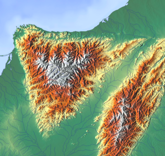
Muisca Confederations were loose confederations of different Muisca chiefdoms in the Eastern Andean highlands of what is today Colombia before the Spanish conquest of northern South America. These unions, centred around main chiefdoms recognised by smaller ones, were not a single, even loose, muisca confederation of chiefdoms, but multiple, independent regional entities. The area, presently called Altiplano Cundiboyacense, comprised the current departments of Boyacá, Cundinamarca and minor parts of Santander.
Usually, Muisca chiefdoms were composed of various basic matrilineal units (uta, minor, or sibyn, major) called capitanías by the Spaniards. However, power was based on individual alliances of Muisca rulers with households or basic units. Often, sibyn were villages and uta groups of houses. Four confederations of chiefdoms formed in Muisca territory: Bogotá, Tunja, Duitama and Sogamoso. Additionally, the Chibcha-speaking Guane and Lache were also ruled by the confederation of Guanentá and the confederation of El Cocuy respectively. Different models exist to explain the nature of power among Muisca elites.
Geography

Climate
| NW: Vélez – 2050 m | |||||||||||
|---|---|---|---|---|---|---|---|---|---|---|---|
| Climate charts for the extremes and four most important settlements of the Muisca Confederation | |||||||||||
| NW: Vélez – 2050 m Climate chart (explanation) J F M A M J J A S O N D 34 19 7 46 19 8 67 19 9 113 19 9 102 18 9 63 18 9 47 18 9 47 18 9 56 18 8 119 18 9 112 18 9 60 19 8 █ Average max. and min. temperatures in °C █ Precipitation totals in mmSource: Imperial conversion JFMAMJJASOND 1.3 67 45 1.8 67 46 2.6 67 47 4.4 66 49 4 65 49 2.5 64 48 1.9 64 48 1.9 64 47 2.2 65 47 4.7 65 47 4.4 65 47 2.4 66 46 █ Average max. and min. temperatures in °F █ Precipitation totals in inches | Lowest: Charalá – 1290 m Climate chart (explanation) J F M A M J J A S O N D 71 29 15 97 29 16 157 29 16 272 28 16 283 28 16 176 27 16 175 29 15 192 28 15 224 28 15 312 27 16 244 27 16 103 28 16 █ Average max. and min. temperatures in °C █ Precipitation totals in mmSource: Imperial conversion JFMAMJJASOND 2.8 83 59 3.8 83 60 6.2 84 60 11 82 61 11 82 61 6.9 81 61 6.9 84 60 7.6 83 59 8.8 82 60 12 81 61 9.6 81 61 4.1 82 60 █ Average max. and min. temperatures in °F █ Precipitation totals in inches | Highest: Aquitania – 3030 m Climate chart (explanation) J F M A M J J A S O N D 11 17 6 22 17 6 49 17 7 139 16 8 219 15 8 113 14 7 109 14 7 94 14 7 83 15 7 109 15 7 75 16 7 24 16 7 █ Average max. and min. temperatures in °C █ Precipitation totals in mmSource: Imperial conversion JFMAMJJASOND 0.4 62 43 0.9 62 44 1.9 63 45 5.5 61 46 8.6 59 46 4.4 57 45 4.3 56 45 3.7 57 45 3.3 58 44 4.3 60 45 3 61 45 0.9 61 44 █ Average max. and min. temperatures in °F █ Precipitation totals in inches | NE: Soatá – 1950 m Climate chart (explanation) J F M A M J J A S O N D 41 25 12 58 25 12 88 25 13 271 24 13 241 23 13 126 23 13 101 23 12 103 23 13 155 24 13 260 23 13 163 23 13 84 24 12 █ Average max. and min. temperatures in °C █ Precipitation totals in mmSource: Imperial conversion JFMAMJJASOND 1.6 76 54 2.3 77 54 3.5 77 55 11 75 56 9.5 74 56 5 73 55 4 74 54 4.1 74 55 6.1 74 55 10 74 55 6.4 74 55 3.3 75 54 █ Average max. and min. temperatures in °F █ Precipitation totals in inches | ||||||||
| Climate chart (explanation) | |||||||||||
| J F M A M J J A S O N D 34 19 7 46 19 8 67 19 9 113 19 9 102 18 9 63 18 9 47 18 9 47 18 9 56 18 8 119 18 9 112 18 9 60 19 8 █ Average max. and min. temperatures in °C █ Precipitation totals in mmSource: | |||||||||||
| J | F | M | A | M | J | J | A | S | O | N | D |
| 34 19 7 | 46 19 8 | 67 19 9 | 113 19 9 | 102 18 9 | 63 18 9 | 47 18 9 | 47 18 9 | 56 18 8 | 119 18 9 | 112 18 9 | 60 19 8 |
| █ Average max. and min. temperatures in °C | |||||||||||
| █ Precipitation totals in mm | |||||||||||
| Source: | |||||||||||
| Imperial conversion JFMAMJJASOND 1.3 67 45 1.8 67 46 2.6 67 47 4.4 66 49 4 65 49 2.5 64 48 1.9 64 48 1.9 64 47 2.2 65 47 4.7 65 47 4.4 65 47 2.4 66 46 █ Average max. and min. temperatures in °F █ Precipitation totals in inches | |||||||||||
| Imperial conversion | |||||||||||
| J | F | M | A | M | J | J | A | S | O | N | D |
| 1.3 67 45 | 1.8 67 46 | 2.6 67 47 | 4.4 66 49 | 4 65 49 | 2.5 64 48 | 1.9 64 48 | 1.9 64 47 | 2.2 65 47 | 4.7 65 47 | 4.4 65 47 | 2.4 66 46 |
| █ Average max. and min. temperatures in °F | |||||||||||
| █ Precipitation totals in inches | |||||||||||
| Lowest: Charalá – 1290 m | |||||||||||
| Climate chart (explanation) | |||||||||||
| J F M A M J J A S O N D 71 29 15 97 29 16 157 29 16 272 28 16 283 28 16 176 27 16 175 29 15 192 28 15 224 28 15 312 27 16 244 27 16 103 28 16 █ Average max. and min. temperatures in °C █ Precipitation totals in mmSource: | |||||||||||
| J | F | M | A | M | J | J | A | S | O | N | D |
| 71 29 15 | 97 29 16 | 157 29 16 | 272 28 16 | 283 28 16 | 176 27 16 | 175 29 15 | 192 28 15 | 224 28 15 | 312 27 16 | 244 27 16 | 103 28 16 |
| █ Average max. and min. temperatures in °C | |||||||||||
| █ Precipitation totals in mm | |||||||||||
| Source: | |||||||||||
| Imperial conversion JFMAMJJASOND 2.8 83 59 3.8 83 60 6.2 84 60 11 82 61 11 82 61 6.9 81 61 6.9 84 60 7.6 83 59 8.8 82 60 12 81 61 9.6 81 61 4.1 82 60 █ Average max. and min. temperatures in °F █ Precipitation totals in inches | |||||||||||
| Imperial conversion | |||||||||||
| J | F | M | A | M | J | J | A | S | O | N | D |
| 2.8 83 59 | 3.8 83 60 | 6.2 84 60 | 11 82 61 | 11 82 61 | 6.9 81 61 | 6.9 84 60 | 7.6 83 59 | 8.8 82 60 | 12 81 61 | 9.6 81 61 | 4.1 82 60 |
| █ Average max. and min. temperatures in °F | |||||||||||
| █ Precipitation totals in inches | |||||||||||
| Highest: Aquitania – 3030 m | |||||||||||
| Climate chart (explanation) | |||||||||||
| J F M A M J J A S O N D 11 17 6 22 17 6 49 17 7 139 16 8 219 15 8 113 14 7 109 14 7 94 14 7 83 15 7 109 15 7 75 16 7 24 16 7 █ Average max. and min. temperatures in °C █ Precipitation totals in mmSource: | |||||||||||
| J | F | M | A | M | J | J | A | S | O | N | D |
| 11 17 6 | 22 17 6 | 49 17 7 | 139 16 8 | 219 15 8 | 113 14 7 | 109 14 7 | 94 14 7 | 83 15 7 | 109 15 7 | 75 16 7 | 24 16 7 |
| █ Average max. and min. temperatures in °C | |||||||||||
| █ Precipitation totals in mm | |||||||||||
| Source: | |||||||||||
| Imperial conversion JFMAMJJASOND 0.4 62 43 0.9 62 44 1.9 63 45 5.5 61 46 8.6 59 46 4.4 57 45 4.3 56 45 3.7 57 45 3.3 58 44 4.3 60 45 3 61 45 0.9 61 44 █ Average max. and min. temperatures in °F █ Precipitation totals in inches | |||||||||||
| Imperial conversion | |||||||||||
| J | F | M | A | M | J | J | A | S | O | N | D |
| 0.4 62 43 | 0.9 62 44 | 1.9 63 45 | 5.5 61 46 | 8.6 59 46 | 4.4 57 45 | 4.3 56 45 | 3.7 57 45 | 3.3 58 44 | 4.3 60 45 | 3 61 45 | 0.9 61 44 |
| █ Average max. and min. temperatures in °F | |||||||||||
| █ Precipitation totals in inches | |||||||||||
| NE: Soatá – 1950 m | |||||||||||
| Climate chart (explanation) | |||||||||||
| J F M A M J J A S O N D 41 25 12 58 25 12 88 25 13 271 24 13 241 23 13 126 23 13 101 23 12 103 23 13 155 24 13 260 23 13 163 23 13 84 24 12 █ Average max. and min. temperatures in °C █ Precipitation totals in mmSource: | |||||||||||
| J | F | M | A | M | J | J | A | S | O | N | D |
| 41 25 12 | 58 25 12 | 88 25 13 | 271 24 13 | 241 23 13 | 126 23 13 | 101 23 12 | 103 23 13 | 155 24 13 | 260 23 13 | 163 23 13 | 84 24 12 |
| █ Average max. and min. temperatures in °C | |||||||||||
| █ Precipitation totals in mm | |||||||||||
| Source: | |||||||||||
| Imperial conversion JFMAMJJASOND 1.6 76 54 2.3 77 54 3.5 77 55 11 75 56 9.5 74 56 5 73 55 4 74 54 4.1 74 55 6.1 74 55 10 74 55 6.4 74 55 3.3 75 54 █ Average max. and min. temperatures in °F █ Precipitation totals in inches | |||||||||||
| Imperial conversion | |||||||||||
| J | F | M | A | M | J | J | A | S | O | N | D |
| 1.6 76 54 | 2.3 77 54 | 3.5 77 55 | 11 75 56 | 9.5 74 56 | 5 73 55 | 4 74 54 | 4.1 74 55 | 6.1 74 55 | 10 74 55 | 6.4 74 55 | 3.3 75 54 |
| █ Average max. and min. temperatures in °F | |||||||||||
| █ Precipitation totals in inches | |||||||||||
| SW: Tibacuy – 1647 m Climate chart (explanation) J F M A M J J A S O N D 72 24 15 90 24 15 109 25 16 170 24 16 155 24 16 88 23 15 57 24 16 52 24 16 80 24 15 214 23 15 216 23 15 100 23 15 █ Average max. and min. temperatures in °C █ Precipitation totals in mmSource: Imperial conversion JFMAMJJASOND 2.8 75 59 3.5 76 60 4.3 76 61 6.7 75 61 6.1 74 61 3.5 74 60 2.2 75 60 2 75 60 3.1 76 59 8.4 74 59 8.5 73 59 3.9 74 59 █ Average max. and min. temperatures in °F █ Precipitation totals in inches | SE: Ubalá – 1949 m Climate chart (explanation) J F M A M J J A S O N D 47 23 11 93 24 12 136 24 13 216 23 14 290 22 14 360 21 13 332 21 13 276 21 13 205 22 12 188 22 13 132 23 13 72 23 12 █ Average max. and min. temperatures in °C █ Precipitation totals in mmSource: Imperial conversion JFMAMJJASOND 1.9 74 52 3.7 74 54 5.4 74 56 8.5 73 57 11 72 57 14 70 56 13 70 55 11 70 55 8.1 71 54 7.4 72 55 5.2 73 55 2.8 73 54 █ Average max. and min. temperatures in °F █ Precipitation totals in inches | ||||||||||
| SW: Tibacuy – 1647 m | |||||||||||
| Climate chart (explanation) | |||||||||||
| J F M A M J J A S O N D 72 24 15 90 24 15 109 25 16 170 24 16 155 24 16 88 23 15 57 24 16 52 24 16 80 24 15 214 23 15 216 23 15 100 23 15 █ Average max. and min. temperatures in °C █ Precipitation totals in mmSource: | |||||||||||
| J | F | M | A | M | J | J | A | S | O | N | D |
| 72 24 15 | 90 24 15 | 109 25 16 | 170 24 16 | 155 24 16 | 88 23 15 | 57 24 16 | 52 24 16 | 80 24 15 | 214 23 15 | 216 23 15 | 100 23 15 |
| █ Average max. and min. temperatures in °C | |||||||||||
| █ Precipitation totals in mm | |||||||||||
| Source: | |||||||||||
| Imperial conversion JFMAMJJASOND 2.8 75 59 3.5 76 60 4.3 76 61 6.7 75 61 6.1 74 61 3.5 74 60 2.2 75 60 2 75 60 3.1 76 59 8.4 74 59 8.5 73 59 3.9 74 59 █ Average max. and min. temperatures in °F █ Precipitation totals in inches | |||||||||||
| Imperial conversion | |||||||||||
| J | F | M | A | M | J | J | A | S | O | N | D |
| 2.8 75 59 | 3.5 76 60 | 4.3 76 61 | 6.7 75 61 | 6.1 74 61 | 3.5 74 60 | 2.2 75 60 | 2 75 60 | 3.1 76 59 | 8.4 74 59 | 8.5 73 59 | 3.9 74 59 |
| █ Average max. and min. temperatures in °F | |||||||||||
| █ Precipitation totals in inches | |||||||||||
| SE: Ubalá – 1949 m | |||||||||||
| Climate chart (explanation) | |||||||||||
| J F M A M J J A S O N D 47 23 11 93 24 12 136 24 13 216 23 14 290 22 14 360 21 13 332 21 13 276 21 13 205 22 12 188 22 13 132 23 13 72 23 12 █ Average max. and min. temperatures in °C █ Precipitation totals in mmSource: | |||||||||||
| J | F | M | A | M | J | J | A | S | O | N | D |
| 47 23 11 | 93 24 12 | 136 24 13 | 216 23 14 | 290 22 14 | 360 21 13 | 332 21 13 | 276 21 13 | 205 22 12 | 188 22 13 | 132 23 13 | 72 23 12 |
| █ Average max. and min. temperatures in °C | |||||||||||
| █ Precipitation totals in mm | |||||||||||
| Source: | |||||||||||
| Imperial conversion JFMAMJJASOND 1.9 74 52 3.7 74 54 5.4 74 56 8.5 73 57 11 72 57 14 70 56 13 70 55 11 70 55 8.1 71 54 7.4 72 55 5.2 73 55 2.8 73 54 █ Average max. and min. temperatures in °F █ Precipitation totals in inches | |||||||||||
| Imperial conversion | |||||||||||
| J | F | M | A | M | J | J | A | S | O | N | D |
| 1.9 74 52 | 3.7 74 54 | 5.4 74 56 | 8.5 73 57 | 11 72 57 | 14 70 56 | 13 70 55 | 11 70 55 | 8.1 71 54 | 7.4 72 55 | 5.2 73 55 | 2.8 73 54 |
| █ Average max. and min. temperatures in °F | |||||||||||
| █ Precipitation totals in inches | |||||||||||
| Bacatá – 2700 m Climate chart (explanation) J F M A M J J A S O N D 34 19 4 46 19 4 67 19 7 113 19 7 102 18 8 63 18 9 47 18 8 47 18 8 56 18 7 119 18 7 112 18 8 60 19 5 █ Average max. and min. temperatures in °C █ Precipitation totals in mmSource: Imperial conversion JFMAMJJASOND 1.3 67 40 1.8 67 38 2.6 67 44 4.4 66 45 4 65 47 2.5 64 48 1.9 64 46 1.9 64 46 2.2 65 45 4.7 65 44 4.4 65 46 2.4 66 41 █ Average max. and min. temperatures in °F █ Precipitation totals in inches | Hunza – 2820 m Climate chart (explanation) J F M A M J J A S O N D 23 19 7 30 19 7 64 19 8 116 18 9 108 18 9 92 16 8 70 16 8 69 17 8 72 17 8 122 17 8 108 18 8 43 18 7 █ Average max. and min. temperatures in °C █ Precipitation totals in mmSource: Imperial conversion JFMAMJJASOND 0.9 66 44 1.2 66 45 2.5 67 47 4.6 65 48 4.3 64 48 3.6 61 47 2.8 61 46 2.7 62 46 2.8 63 46 4.8 63 47 4.3 64 47 1.7 65 45 █ Average max. and min. temperatures in °F █ Precipitation totals in inches | Suamox – 2569 m Climate chart (explanation) J F M A M J J A S O N D 19 22 8 31 22 9 58 22 9 114 21 10 107 20 10 65 19 9 49 19 9 51 20 9 64 20 9 116 20 10 89 21 9 35 21 8 █ Average max. and min. temperatures in °C █ Precipitation totals in mmSource: Imperial conversion JFMAMJJASOND 0.7 71 47 1.2 72 47 2.3 72 48 4.5 69 50 4.2 68 50 2.6 67 49 1.9 66 47 2 67 48 2.5 68 48 4.6 68 49 3.5 69 49 1.4 70 47 █ Average max. and min. temperatures in °F █ Precipitation totals in inches | Tundama – 2590 m Climate chart (explanation) J F M A M J J A S O N D 21 21 7 43 22 8 65 22 8 123 20 9 126 20 9 75 19 9 54 19 8 54 19 8 74 20 8 143 19 9 92 20 9 42 21 7 █ Average max. and min. temperatures in °C █ Precipitation totals in mmSource: Imperial conversion JFMAMJJASOND 0.8 70 45 1.7 71 46 2.6 71 46 4.8 69 49 5 67 49 3 66 47 2.1 66 46 2.1 67 46 2.9 67 46 5.6 67 48 3.6 68 47 1.7 69 45 █ Average max. and min. temperatures in °F █ Precipitation totals in inches | ||||||||
| Bacatá – 2700 m | |||||||||||
| Climate chart (explanation) | |||||||||||
| J F M A M J J A S O N D 34 19 4 46 19 4 67 19 7 113 19 7 102 18 8 63 18 9 47 18 8 47 18 8 56 18 7 119 18 7 112 18 8 60 19 5 █ Average max. and min. temperatures in °C █ Precipitation totals in mmSource: | |||||||||||
| J | F | M | A | M | J | J | A | S | O | N | D |
| 34 19 4 | 46 19 4 | 67 19 7 | 113 19 7 | 102 18 8 | 63 18 9 | 47 18 8 | 47 18 8 | 56 18 7 | 119 18 7 | 112 18 8 | 60 19 5 |
| █ Average max. and min. temperatures in °C | |||||||||||
| █ Precipitation totals in mm | |||||||||||
| Source: | |||||||||||
| Imperial conversion JFMAMJJASOND 1.3 67 40 1.8 67 38 2.6 67 44 4.4 66 45 4 65 47 2.5 64 48 1.9 64 46 1.9 64 46 2.2 65 45 4.7 65 44 4.4 65 46 2.4 66 41 █ Average max. and min. temperatures in °F █ Precipitation totals in inches | |||||||||||
| Imperial conversion | |||||||||||
| J | F | M | A | M | J | J | A | S | O | N | D |
| 1.3 67 40 | 1.8 67 38 | 2.6 67 44 | 4.4 66 45 | 4 65 47 | 2.5 64 48 | 1.9 64 46 | 1.9 64 46 | 2.2 65 45 | 4.7 65 44 | 4.4 65 46 | 2.4 66 41 |
| █ Average max. and min. temperatures in °F | |||||||||||
| █ Precipitation totals in inches | |||||||||||
| Hunza – 2820 m | |||||||||||
| Climate chart (explanation) | |||||||||||
| J F M A M J J A S O N D 23 19 7 30 19 7 64 19 8 116 18 9 108 18 9 92 16 8 70 16 8 69 17 8 72 17 8 122 17 8 108 18 8 43 18 7 █ Average max. and min. temperatures in °C █ Precipitation totals in mmSource: | |||||||||||
| J | F | M | A | M | J | J | A | S | O | N | D |
| 23 19 7 | 30 19 7 | 64 19 8 | 116 18 9 | 108 18 9 | 92 16 8 | 70 16 8 | 69 17 8 | 72 17 8 | 122 17 8 | 108 18 8 | 43 18 7 |
| █ Average max. and min. temperatures in °C | |||||||||||
| █ Precipitation totals in mm | |||||||||||
| Source: | |||||||||||
| Imperial conversion JFMAMJJASOND 0.9 66 44 1.2 66 45 2.5 67 47 4.6 65 48 4.3 64 48 3.6 61 47 2.8 61 46 2.7 62 46 2.8 63 46 4.8 63 47 4.3 64 47 1.7 65 45 █ Average max. and min. temperatures in °F █ Precipitation totals in inches | |||||||||||
| Imperial conversion | |||||||||||
| J | F | M | A | M | J | J | A | S | O | N | D |
| 0.9 66 44 | 1.2 66 45 | 2.5 67 47 | 4.6 65 48 | 4.3 64 48 | 3.6 61 47 | 2.8 61 46 | 2.7 62 46 | 2.8 63 46 | 4.8 63 47 | 4.3 64 47 | 1.7 65 45 |
| █ Average max. and min. temperatures in °F | |||||||||||
| █ Precipitation totals in inches | |||||||||||
| Suamox – 2569 m | |||||||||||
| Climate chart (explanation) | |||||||||||
| J F M A M J J A S O N D 19 22 8 31 22 9 58 22 9 114 21 10 107 20 10 65 19 9 49 19 9 51 20 9 64 20 9 116 20 10 89 21 9 35 21 8 █ Average max. and min. temperatures in °C █ Precipitation totals in mmSource: | |||||||||||
| J | F | M | A | M | J | J | A | S | O | N | D |
| 19 22 8 | 31 22 9 | 58 22 9 | 114 21 10 | 107 20 10 | 65 19 9 | 49 19 9 | 51 20 9 | 64 20 9 | 116 20 10 | 89 21 9 | 35 21 8 |
| █ Average max. and min. temperatures in °C | |||||||||||
| █ Precipitation totals in mm | |||||||||||
| Source: | |||||||||||
| Imperial conversion JFMAMJJASOND 0.7 71 47 1.2 72 47 2.3 72 48 4.5 69 50 4.2 68 50 2.6 67 49 1.9 66 47 2 67 48 2.5 68 48 4.6 68 49 3.5 69 49 1.4 70 47 █ Average max. and min. temperatures in °F █ Precipitation totals in inches | |||||||||||
| Imperial conversion | |||||||||||
| J | F | M | A | M | J | J | A | S | O | N | D |
| 0.7 71 47 | 1.2 72 47 | 2.3 72 48 | 4.5 69 50 | 4.2 68 50 | 2.6 67 49 | 1.9 66 47 | 2 67 48 | 2.5 68 48 | 4.6 68 49 | 3.5 69 49 | 1.4 70 47 |
| █ Average max. and min. temperatures in °F | |||||||||||
| █ Precipitation totals in inches | |||||||||||
| Tundama – 2590 m | |||||||||||
| Climate chart (explanation) | |||||||||||
| J F M A M J J A S O N D 21 21 7 43 22 8 65 22 8 123 20 9 126 20 9 75 19 9 54 19 8 54 19 8 74 20 8 143 19 9 92 20 9 42 21 7 █ Average max. and min. temperatures in °C █ Precipitation totals in mmSource: | |||||||||||
| J | F | M | A | M | J | J | A | S | O | N | D |
| 21 21 7 | 43 22 8 | 65 22 8 | 123 20 9 | 126 20 9 | 75 19 9 | 54 19 8 | 54 19 8 | 74 20 8 | 143 19 9 | 92 20 9 | 42 21 7 |
| █ Average max. and min. temperatures in °C | |||||||||||
| █ Precipitation totals in mm | |||||||||||
| Source: | |||||||||||
| Imperial conversion JFMAMJJASOND 0.8 70 45 1.7 71 46 2.6 71 46 4.8 69 49 5 67 49 3 66 47 2.1 66 46 2.1 67 46 2.9 67 46 5.6 67 48 3.6 68 47 1.7 69 45 █ Average max. and min. temperatures in °F █ Precipitation totals in inches | |||||||||||
| Imperial conversion | |||||||||||
| J | F | M | A | M | J | J | A | S | O | N | D |
| 0.8 70 45 | 1.7 71 46 | 2.6 71 46 | 4.8 69 49 | 5 67 49 | 3 66 47 | 2.1 66 46 | 2.1 67 46 | 2.9 67 46 | 5.6 67 48 | 3.6 68 47 | 1.7 69 45 |
| █ Average max. and min. temperatures in °F | |||||||||||
| █ Precipitation totals in inches | |||||||||||
| The climates (Af-Cfb-Cwb) of the geographic (NW, NE, SW and SE) and topographic extremes and for the four main settlements of the Muisca Confederation situated on the Altiplano, from SW to NE; Bacatá, Hunza, Suamox and Tundama are rather constant over the year with wetter periods in April–May and October–November |
Muisca Confederations

The Muiscas lived in the Andes Orientales in a territory of approximately 22.000 km2. At the time of the Spanish Conquest, four confederations existed in their territory (Bogotá, Tunja, Duitama, Sogamoso). According to colonial documents, the confederations of Sogamoso and Duitama were independent of Tunja and had great importance. Political power was not based on economic or political subordination but recognition of certain authorities, sometimes multiple at a time. The size of muisca population remains debated. The most powerful chiefdom at the time of the Spanish conquest was Bogotá. Additionally, there were independent chiefdoms in the north-west, not affilitiated to any confederation.
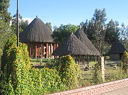
Muisca settlements were organised around the cacique's enclosure or cercado. Roads were present to connect the settlements with each other and with the surrounding indigenous groups, of which the Guane and Lache to the north, the Panche and Muzo to the west and Guayupe, Achagua and Tegua to the east were the most important.[citation needed]
History
Prehistory
Early Amerindian settlers led a hunter-gatherer life among still extant megafauna living in cool habitats around Pleistocene lakes, of which the humedales in Bogotá, Lake Suesca, Lake Fúquene and Lake Herrera are notable examples. Multiple evidences of late Pleistocene to middle Holocene population of the Bogotá savanna, the high plateau in the Colombian Andes, have been found to date. As is common with caves and rock shelters, Tequendama was inhabited from around 11,000 years BP, and continuing into the prehistorical, Herrera and Muisca periods, making it the oldest site of Colombia, together with El Abra (12,500 BP), located north of Zipaquirá and Tibitó, located within the boundaries of Tocancipá (11,740 BP). The oldest human remains and the oldest complete skeleton were discovered at Tequendama and has been named "Hombre del Tequendama" or Homo Tequendama. Other artefacts have been found in Gachalá (9100 BP), Sueva (Junín) and Zipacón. Just west of the Altiplano, the oldest archaeological remains were found; in Pubenza, part of Tocaima and have been dated at 16,000 years Before Present.
Pre-Columbian era
| Timeline of inhabitation of the Altiplano Cundiboyacense, Colombia | |
| Altiplano Muisca Confederation |
Herrera Period
| Period name | Start age | End age |
|---|---|---|
| Herrera | 800 BCE | 800 |
| Early Muisca | 800 | 1200 |
| Late Muisca | 1200 | 1537 |
| Kruschek, 2003 |
The Herrera Period is a historical period named after the La Herrera lake, south of Bogotá, it took place approximately between 800 BCE to 800 AD. However, current academic consensus considers the period to have ranged from 400 B.C. to 1000 A.D., with regional variations. The muisca arrival to the Altiplano Cundibyacense most likely pre-dated the beginning of the Herrera period. However, the exact date of their arrival is unknown, and the least oldest date would be the middle of the first millennium B.C.
Generally, the Herrera period is characterized by agriculture, ceramic traditions and the use of salt sources. The political organisation and level of social complexity during the Herrera period is uncertain.
Muisca
The period named "Muisca" is separated by scholars into "early muisca" (approximately 1000–1200 A.D.) and "late muisca" (apr. 1200–1600). This period is associated with the rise of muisca chiefdoms. Through the construction of monolithic structures, elites acquired an ideological more than a direct economic control. The reasons for the expansion of chiefdoms are uncertain. According to Gerardo Reichel-Dolmatoff, the north-western, independent chiefdoms are representative of the state of Muisca society prior to the creation of confederations. Possibly, matrimonial alliances, conducted independently of the "territory" assigned to each chiefdom, played an important role. Two traditions of chroniclers reported different versions of Bogotá expansion: According to Juan Rodríguez Freyle, Bogotá's expansion began just one year before the Spanish conquest, after having revolted against the previously dominant chiefdom of Guatavita. On the other hand, Lucas Fernández de Piedrahíta related Bogotá's expansion in the course of 67 years, as the result of various military campaigns led by different chiefs. According to Martha Herrera Angel, the colonial-era writings, while filled with exaggerations and misunderstandings, contain a core of historical truth.
The concept of gue ("house") was essential for muisca chiefs to secure their legitimacy, which was based on rules of succession and a certain degree of popular consent. Their role was to redistribute an accumulated surplus of goods, not to accumulate them. The existence of religious specialists can be explained by the need to maintain the equilibrium of the world.
The people used a decimal counting system, based on the digits of the hand. Their system went from 1 to 10 and for higher numerations they used the prefix quihicha or qhicha, which means "foot" in their Chibcha language Muysccubun. Eleven became thus "foot one", twelve "foot two", etc. As in the other pre-Columbian civilizations, the number 20 was special. It was the total number of all body extremities; fingers and toes. The Muisca used two forms to express twenty: "foot ten"; quihícha ubchihica or their exclusive word gueta, derived from gue, which means "house". Numbers between 20 and 30 were counted gueta asaqui ata ("twenty plus one"; 21), gueta asaqui ubchihica ("twenty plus ten"; 30). Larger numbers were counted as multiples of twenty; gue-bosa ("20 times 2"; 40), gue-hisca ("20 times 5"; 100). The Muisca script consisted of hieroglyphs, only used for numerals. Gold was not the main object of prestige, but had religious significance, as chiefs preferred exotic clothing and sumptuous palisades to show their power. There was no currency among the Muiscas.
Territorial organization
| History of the Muisca | |||||||||
| Altiplano | Muisca | Art | Architecture | Astronomy | Cuisine | El Dorado | Subsistence | Women | Conquest |
Bacatá

- Capital – Bacatá
- Area – 5,430 square kilometres (2,100 sq mi)
- Average elevation – 2,470 metres (8,100 ft)
- Last rulers – zipas Tisquesusa, Sagipa
- Date of conquest – 20 April 1537 (Funza) – Jiménez & Pérez de Quesada
- First city – 6 August 1538 (Bogotá) – Gonzalo Jiménez de Quesada
| Municipality | Department bold is capital | Ruler(s) bold is seat | Altitude urban centre (m) | Surface area (km2) | Remarks | Map |
|---|---|---|---|---|---|---|
| Bacatá | Cundinamarca | zipa | 2640 | 1587 | Muisca mummy found Important market town Petrographs found | |
| Bojacá | Cundinamarca | zipa | 2598 | 109 | Lake Herrera Petrographs found | |
| Cajicá | Cundinamarca | zipa | 2558 | 50.4 | ||
| La Calera | Cundinamarca | zipa | 2718 | 317 | Petrographs found | |
| Cáqueza | Cundinamarca | zipa | 1746 | 38 | ||
| Chía | Cundinamarca | zipa | 2564 | 80 | Moon Temple Herrera site Petrographs found | |
| Choachí | Cundinamarca | zipa | 1923 | 223 | Choachí Stone found | |
| Chocontá | Cundinamarca | zipa | 2655 | 301.1 | Important market town Battle of Chocontá (~1490) Fortification between zipa & zaque | |
| Cogua | Cundinamarca | zipa | 2600 | 113 | Muisca ceramics production Petrographs found | |
| Cota | Cundinamarca | zipa | 2566 | 55 | Petrographs found Still Muisca people living | |
| Cucunubá | Cundinamarca | zipa | 2590 | 112 | Petrographs found | |
| Facatativá | Cundinamarca | zipa | 2586 | 158 | Piedras del Tunjo | |
| Funza | Cundinamarca | zipa | 2548 | 70 | Important market town | |
| Gachancipá | Cundinamarca | zipa | 2568 | 44 | Muisca mummy found Muisca ceramics production | |
| Guasca | Cundinamarca | zipa | 2710 | 346 | Siecha Lakes Muisca ceramics production Petrographs found | |
| Madrid | Cundinamarca | zipa | 2554 | 120.5 | Lake Herrera Petrographs found | |
| Mosquera | Cundinamarca | zipa | 2516 | 107 | Lake Herrera Petrographs found | |
| Nemocón | Cundinamarca | zipa | 2585 | 98.1 | Muisca salt mines Preceramic site Checua Petrographs found | |
| Pacho | Cundinamarca | zipa | 2136 | 403.3 | Important market town | |
| Pasca | Cundinamarca | zipa | 2180 | 246.24 | Battle of Pasca (~1470) Muisca raft found | |
| El Rosal | Cundinamarca | zipa | 2685 | 86.48 | ||
| San Antonio del Tequendama | Cundinamarca | zipa | 1540 | 82 | Tequendama Falls Fortification against Panche Petrographs found | |
| Sesquilé | Cundinamarca | zipa | 2595 | 141 | Lake Guatavita Minor Muisca salt mines | |
| Sibaté | Cundinamarca | zipa | 2700 | 125.6 | Petrographs found | |
| Soacha | Cundinamarca | zipa | 2565 | 184.45 | Preceramic site Tequendama Herrera site Muisca ceramics production Petrographs found | |
| Sopó | Cundinamarca | zipa | 2650 | 111.5 | Herrera site | |
| Subachoque | Cundinamarca | zipa | 2663 | 211.53 | Petrographs found | |
| Suesca | Cundinamarca | zipa | 2584 | 177 | 150 Muisca mummies found Lake Suesca Muisca ceramics production Important market town Petrographs found | |
| Sutatausa | Cundinamarca | zipa | 2550 | 67 | Petrographs found | |
| Tabio | Cundinamarca | zipa | 2569 | 74.5 | Hot springs used by the Muisca | |
| Tausa | Cundinamarca | zipa | 2931 | 204 | Muisca salt mines Petrographs found | |
| Tena | Cundinamarca | zipa | 1384 | 55 | Fortification against Panche Petrographs found | |
| Tenjo | Cundinamarca | zipa | 2587 | 108 | Petrographs found | |
| Tibacuy | Cundinamarca | zipa & Panche | 1647 | 84.4 | Border with Panche Fortification against Panche & Sutagao Petrographs found | |
| Tocancipá | Cundinamarca | zipa | 2605 | 73.51 | Preceramic site Tibitó Muisca ceramics production Important market town Petrographs found | |
| Zipaquirá | Cundinamarca | zipa | 2650 | 197 | El Abra Muisca salt mines Important market town Petrographs and petroglyphs found | |
| Fúquene | Cundinamarca | zipa zaque | 2750 | 90 | Lake Fúquene | |
| Simijaca | Cundinamarca | zipa (1490–1537) | 2559 | 107 | Conquered by zipa Saguamanchica upon zaque Michuá (~1490) | |
| Susa | Cundinamarca | zipa (1490–1537) | 2655 | 86 | Conquered by zipa Saguamanchica upon zaque Michuá (~1490) Lake Fúquene | |
| Ubaté | Cundinamarca | zipa (1490–1537) | 2556 | 102 | Conquered by zipa Saguamanchica upon zaque Michuá (~1490) Muisca mummy found | |
| Zipacón | Cundinamarca | zipa | 2550 | 70 | Agriculture Place of meditation for the zipa Petrographs found |
Chipazaque

| Municipality | Department | Ruler(s) | Altitude (m) | Surface area (km2) | Remarks | Map |
|---|---|---|---|---|---|---|
| Junín | Cundinamarca | chipazaque | 2300 | 337 | Shared between zipa and zaque Petrographs found |
Hunza

- Capital – Hunza
- Area – 4,700 square kilometres (1,800 sq mi)
- Average elevation – 2,270 metres (7,450 ft)
- Last rulers – zaques Quemuenchatocha, Aquiminzaque
- Date of conquest – 20 August 1537 (Hunza) – Jiménez & Pérez de Quesada
- First city – 6 August 1539 (Tunja) – Gonzalo Suárez Rendón
| Municipality | Department bold is capital | Ruler(s) bold is seat | Altitude (m) | Surface area (km2) | Remarks | Map |
|---|---|---|---|---|---|---|
| Hunza | Boyacá | zaque | 2820 | 121.4 | Hunzahúa Well Cojines del Zaque Goranchacha Temple Muisca mummy found Important market town Petrographs found | |
| Boyacá | Boyacá | zaque | 2420 | 48 | ||
| Buenavista | Boyacá | zaque | 2100 | 125 | Border with Muzo Nose piece and pectoral found, dated at 620 and 990 AD respectively | |
| Chinavita | Boyacá | zaque | 1763 | 148 | ||
| Chíquiza | Boyacá | zaque | 2900 | 119.52 | Lake Iguaque | |
| Chitaraque | Boyacá | zaque | 1575 | 157.65 | ||
| Chivatá | Boyacá | zaque | 2903 | 56 | ||
| Ciénega | Boyacá | zaque | 2460 | 73 | ||
| Cucaita | Boyacá | zaque | 2650 | 43.58 | ||
| Gachantivá | Boyacá | zaque | 2450 | 66 | Muisca mummy found Muisca copper mines | |
| Garagoa | Boyacá | zaque | 1650 | 191.75 | ||
| Macanal | Boyacá | zaque | 1680 | 199.5 | Border with Tegua | |
| Motavita | Boyacá | zaque | 2690 | 62 | Coca market town Petrographs found | |
| Oicatá | Boyacá | zaque | 2815 | 59 | ||
| Pachavita | Boyacá | zaque | 1985 | 68 | ||
| Ramiriquí | Boyacá | zaque | 2325 | 146.5 | Place of death of Quemuenchatocha Important ceramics production Petrographs found | |
| Sáchica | Boyacá | zaque | 2150 | 62.4 | Petrographs found | |
| Samacá | Boyacá | zaque | 2660 | 172.9 | ||
| San Miguel de Sema | Boyacá | zaque | 2615 | 90 | Lake Fúquene | |
| Siachoque | Boyacá | zaque | 2760 | 125 | ||
| Somondoco | Boyacá | zaque | 1670 | 58.7 | Muisca emerald mines Important market town | |
| Sutamarchán | Boyacá | zaque | 1800 | 102 | Muisca ceramics production | |
| Tinjacá | Boyacá | zaque | 2175 | 79.3 | Muisca ceramics production | |
| Tipacoque | Boyacá | zaque | 1850 | 72.1 | Chicamocha Canyon | |
| Turmequé | Boyacá | zaque | 2389 | 106 | Important market town Fortification between zipa & zaque | |
| Villa de Leyva | Boyacá | zaque | 2149 | 128 | El Infiernito Lake Iguaque Muisca mummy found Important market town | |
| Sora | Boyacá | zaque | 2650 | 42 | ||
| Soracá | Boyacá | zaque | 2942 | 57 | ||
| Sotaquirá | Boyacá | zaque | 2860 | 288.65 | ||
| Sutatenza | Boyacá | zaque | 1890 | 41.26 | ||
| Tibaná | Boyacá | zaque | 2115 | 121.76 | Petrographs found | |
| Togüí | Boyacá | zaque | 1650 | 118 | ||
| Tuta | Boyacá | zaque | 2600 | 165 | ||
| Ventaquemada | Boyacá | zaque | 2630 | 159.3 | ||
| Viracachá | Boyacá | zaque | 2520 | 68 | ||
| Zetaquirá | Boyacá | zaque | 1665 | 262 | ||
| Almeida | Boyacá | zaque | 1925 | 57.98 | ||
| La Capilla | Boyacá | zaque | 1750 | 57.26 | ||
| Jenesano | Boyacá | zaque | 2076 | 59 | ||
| Nuevo Colón | Boyacá | zaque | 2500 | 51 | ||
| Rondón | Boyacá | zaque | 2075 | 158 | ||
| Lenguazaque | Cundinamarca | zaque | 2589 | 15.36 | ||
| Machetá | Cundinamarca | zaque | 2094 | 229.35 | Petrographs found | |
| Tibiritá | Cundinamarca | zaque | 1980 | 57.2 | Petrographs found | |
| Villapinzón | Cundinamarca | zaque | 2715 | 249 |
Iraca

- Capital – Suamox
- Area – 4,163 square kilometres (1,607 sq mi)
- Average elevation – 2,630 metres (8,630 ft)
- Last ruler – iraca Sugamuxi
- Date of conquest – Early September 1537 (Sogamoso) – Jiménez & Pérez de Quesada
- Important settlements – Suamox, Busbanzá, Firavitoba, Gámeza and Tota
- Archaeological remains – mummies, Sun Temple reconstruction, Lake Tota
| Municipality | Department | Ruler(s) bold is seat | Altitude (m) | Surface area (km2) | Remarks | Map |
|---|---|---|---|---|---|---|
| Suamox | Boyacá | iraca Nompanim Sugamuxi | 2569 | 208.54 | Sun Temple Muisca mummy found Muisca carbon mines | |
| Aquitania | Boyacá | iraca | 3030 | 943 | Lake Tota | |
| Busbanzá | Boyacá | iraca | 2472 | 22.5 | Elector of new iraca | |
| Cuítiva | Boyacá | iraca | 2750 | 43 | Lake Tota Statue of Bochica | |
| Firavitoba | Boyacá | iraca | 2500 | 109.9 | Elector of new iraca | |
| Gámeza | Boyacá | iraca | 2750 | 88 | Herrera site Muisca mummy found Minor Muisca salt mines Muisca carbon mines Petrographs found | |
| Iza | Boyacá | iraca | 2560 | 34 | Herrera site Lake Tota Petrographs found | |
| Mongua | Boyacá | iraca | 2975 | 365.5 | Petrographs found | |
| Monguí | Boyacá | iraca | 2900 | 81 | Petroglyphs Birthplaces (Tortolitas) | |
| Pesca | Boyacá | iraca | 2858 | 282 | ||
| Tasco | Boyacá | iraca | 2530 | 167 | Muisca mummy found | |
| Toca | Boyacá | iraca | 2810 | 165 | ||
| Tota | Boyacá | iraca | 2870 | 314 | Lake Tota | |
| Socotá | Boyacá | iraca Tundama | 2443 | 600.11 | Muisca mummy found | |
| Tibasosa | Boyacá | Tundama iraca | 2538 | 94.3 |
Tundama

- Capital – Tundama
- Area – 2,920 square kilometres (1,130 sq mi)
- Average elevation – 2,470 metres (8,100 ft)
- Last ruler – Tundama
- Date of conquest – Late December 1539 (Duitama) – Baltasar Maldonado
- Important settlements – Tundama, Onzaga, Soatá, Chitagoto (now Paz de Río)
| Municipality | Department | Ruler(s) bold is seat | Altitude (m) | Surface area (km2) | Remarks | Map |
|---|---|---|---|---|---|---|
| Tundama | Boyacá | Tundama | 2590 | 266.93 | Seat of Tundama In ancient lake | |
| Onzaga | Santander | Tundama | 1960 | 486.76 | Important for wool and cotton production | |
| Cerinza | Boyacá | Tundama | 2750 | 61.63 | Monument to the Muisca | |
| Paz de Río | Boyacá | Tundama | 2200 | 116 | Coca market town | |
| Paipa | Boyacá | Tundama | 2525 | 305.924 | Thermal springs | |
| Sativanorte | Boyacá | Tundama | 2600 | 184 | Herrera site | |
| Sativasur | Boyacá | Tundama | 2600 | 81 | Muisca mummy SO10-IX found Herrera site | |
| Soatá | Boyacá | Tundama | 1950 | 136 | Herrera site Coca market town | |
| Belén | Boyacá | Tundama | 2650 | 83.6 | Petrographs found | |
| Corrales | Boyacá | Tundama | 2470 | 60.85 | ||
| Floresta | Boyacá | Tundama | 2506 | 86 | ||
| Nobsa | Boyacá | Tundama | 2510 | 55.39 | ||
| Santa Rosa de Viterbo | Boyacá | Tundama | 2753 | 107 | ||
| Susacón | Boyacá | Tundama | 2480 | 191 | ||
| Tibasosa | Boyacá | Tundama iraca | 2538 | 94.3 | ||
| Socotá | Boyacá | iraca Tundama | 2443 | 600.11 | Muisca mummy found |
Independent caciques
- Capital – none
- Area – 3,080 square kilometres (1,190 sq mi)
- Average elevation – 2,140 metres (7,020 ft)
- Important caciques – Guatavita, Ubaté, Chiquinquirá, Ubaque, Tenza, Vélez
| Municipality bold is major cacique | Department | Ruler(s) | Altitude (m) | Surface area (km2) | Remarks | Map |
|---|---|---|---|---|---|---|
| Vélez | Santander | cacique | 2050 | 271.34 | ||
| Chipatá | Santander | cacique | 1820 | 94.17 | First town conquered by the Spanish | |
| Güepsa | Santander | cacique | 1540 | 33.08 | Border with Guane Border with Yarigui | |
| Charalá | Santander | cacique | 1290 | 411 | Border with Guane | |
| Arcabuco | Boyacá | cacique | 2739 | 155 | Statue honouring the Muisca warriors | |
| Betéitiva | Boyacá | cacique | 2575 | 123 | ||
| Boavita | Boyacá | cacique | 2114 | 159 | Muisca mummy found | |
| Chiquinquirá | Boyacá | cacique | 2556 | 133 | ||
| Cómbita | Boyacá | cacique | 2825 | 149 | ||
| Covarachía | Boyacá | cacique | 2320 | 103 | Herrera site | |
| Guateque | Boyacá | cacique | 1815 | 36.04 | Religious rituals at Guatoc hill | |
| Guayatá | Boyacá | cacique | 1767 | 112 | Muisca money (tejuelo) found | |
| Moniquirá | Boyacá | cacique | 1669 | 220 | Muisca mummy found Muisca copper mines | |
| Pisba | Boyacá | cacique | 2400 | 469.12 | Muisca mummy found | |
| Ráquira | Boyacá | cacique | 2150 | 233 | Muisca ceramics production | |
| Saboyá | Boyacá | cacique | 2600 | 246.9 | Petrographs found | |
| Tópaga | Boyacá | cacique | 2900 | 37 | Muisca mummy found Muisca carbon mines | |
| Tutazá | Boyacá | cacique | 1890 | 135 | Muisca ceramics production | |
| Tenza | Boyacá | cacique | 1600 | 51 | Tenza Valley | |
| Chivor | Boyacá | cacique | 1800 | 108.36 | Muisca emerald mines | |
| Úmbita | Boyacá | cacique | 2480 | 148.17 | ||
| Carmen de Carupa | Cundinamarca | cacique | 2600 | 228 | Tunjo found | |
| Guatavita | Cundinamarca | cacique | 2680 | 247.3 | Muisca ceramics production Main goldworking town Petrographs found | |
| Gachetá | Cundinamarca | cacique Guatavita | 1745 | 262.2 | ||
| Guachetá | Cundinamarca | cacique | 2688 | 177.45 | Minor Muisca salt mines Petrographs found | |
| Manta | Cundinamarca | cacique | 1924 | 105 | ||
| Ubaque | Cundinamarca | cacique | 1867 | 104.96 | Last public religious ritual (1563) Lake Ubaque | |
| Ubalá | Cundinamarca | cacique | 1949 | 505 | Muisca emerald mines | |
| Chipaque | Cundinamarca | cacique | 2400 | 139.45 | Petrographs found | |
| Fómeque | Cundinamarca | cacique | 1895 | 555.7 | ||
| Quetame | Cundinamarca | cacique | 1496 | 138.47 | ||
| Une | Cundinamarca | cacique | 2376 | 221 | ||
| Fosca | Cundinamarca | cacique | 2080 | 126.02 | Fortification against Guayupe |
Neighbouring indigenous groups
| Yarigui | Guane | Lache | U'wa |
| Muzo | |||
| Panche | Achagua | ||
| Sutagao | Guayupe | Tegua | |
| Cariban languages • Chibchan languages • Arawakan languages | |||
| Yarigui and Lache not shown on map • Tegua shown as Tecua • U'wa shown as Tunebo | |||
- Panche Cariban-speaking frequent warfare beaten in the Battle of Tocarema pathways to gold conquest by Hernán Venegas Carrillo (1543–44)
- Muzo or The Emerald people Cariban-speaking trading access to western neighbours Furatena pathways to gold conquest by Luis Lanchero (1539–1559)
- Guane Chibcha-speaking producers of cotton for mantle making producers of fruits access to La Tora (Barrancabermeja); trading sea shells at Magdalena River conquest by Martín Galeano (1539–1551)
Sacred sites
The sacred sites of the Muisca Confederation were based in the Muisca religion and mythology. The Muisca were a highly religious people with their own beliefs on the origin of the Earth and life and human sacrifices were no exception to please the gods for good harvests and prosperity.
Lake Guatavita, Guatavita, was the location where the new zipa would be inaugurated. It became known with the Spanish conquerors as the site of El Dorado where the new zipa was covered in gold dust and installed as the new ruler of the southern Muisca.
In the legends of the Muisca, humankind originated in Lake Iguaque, Monquirá, when the goddess Bachué came out from the lake with a boy in her arms. When the boy grew, they populated the Earth. They are considered the ancestors of the human race. Finally, they disappeared unto the lake in the shape of snakes.
According to Muisca myths, the Tequendama Falls, outside Soacha, was the site where the first zipa Meicuchuca lost his lover who turned in a snake and disappeared in the waters of the Bogotá River.
El Infiernito, close to the present town of Villa de Leyva was a sacred site where the Muisca erected structures based on astronomical parameters.
Other sacred sites
- Sun Temple, Sogamoso
- Hunzahúa Well, Tunja
- Goranchacha Temple, Tunja
- Cojines del Zaque, Tunja
- Moon Temple, Chía
- Lake Guatavita; site of El Dorado
- Lake Iguaque
- Tequendama Falls
- El Infiernito; astronomical site
- Cojines del Zaque
Spanish conquests
Conquest and early colonial period
The conquest of the Muisca was the heaviest of all four Spanish expeditions to the great American civilisations. More than 80 percent of the soldiers and horses that started the journey of a year to the northern Muisca Confederation did not survive it. Various settlements were founded by the Spanish between 1537 and 1539.
A delegation of more than 900 men left the tropical city of Santa Marta and went on a harsh expedition through the heartlands of Colombia in search of El Dorado and the civilisation that produced all this precious gold. The leader of the first and main expedition under Spanish flag was Gonzalo Jiménez de Quesada, with his brother Hernán second in command. Several other soldiers were participating in the journey, who would later become encomenderos and taking part in the conquest of other parts of Colombia. Other contemporaneous expeditions into the unknown interior of the Andes, all searching for the mythical land of gold, were starting from later Venezuela, led by Bavarian and other German conquistadors and from the south, starting in the previously founded Kingdom of Quito in later Ecuador.
The first phase of the conquest was ended by the victory of the few conquistadors left over Tisquesusa, the last zipa of Bacatá, who fell and died after the battle at Funza, on the Bogotá savanna, 20 April 1537. The arrival of the Spanish conquerors was revealed to Tisquesusa by the mohan Popón, from the village of Ubaque. He told the Muisca ruler that foreigners were coming and Tisquesusa would die "bathing in his own blood". When Tisquesusa was informed of the advancing invasion of the Spanish soldiers, he sent a spy to Suesca to find out more about their army strength, weapons and with how many warriors they could be beaten. The zipa left the capital Bacatá and took shelter in Nemocón which directed the Spanish troops to there, during this march attacked by more than 600 Muisca warriors.
When Tisquesusa retreated in his fort in Cajicá he allegedly told his men he would not be able to combat against the strong Spanish army in possession of weapons that produced "thunder and lightning". He chose to return to Bacatá and ordered the capital to be evacuated, resulting in an abandoned site when the Spanish arrived. In search for the Muisca ruler the conquistadores went north to find Tisquesusa in the surroundings of Facatativá where they attacked him at night.
Tisquesusa was thrusted by the sword of one of De Quesada's soldiers but without knowing he was the zipa he let him go, after taking the expensive mantle of the ruler. Tisquesusa fled hurt into the mountains and died of his wounds there. His body was only discovered a year later because of the black vultures circling over it.
When Gonzalo Jiménez de Quesada found out the caciques were conspiring against him, he sent out several expeditions of soldiers. His captain Juan de Céspedes went south to found Pasca on 15 July 1537. Hernán was sent north and Gonzalo himself went northeast, to search for the mythical Land of Gold El Dorado. There he did not find golden cities, but emeralds, the Muisca were extracting in Chivor and Somondoco. First foundation was Engativá, presently a locality of Bogotá, on 22 May 1537. Passing through Suba, Chía, Cajicá, Tocancipá, Gachancipá, Guatavita and Sesquilé, he arrived in Chocontá, founding the modern town on 9 June. The journey went eastward into the Tenza Valley through Machetá, Tibiritá, Guateque, Sutatenza and Tenza, founded on San Juan; 24 June. On the same day, Hernán founded Sutatausa. Gonzalo continued northwest through La Capilla and Úmbita. He arrived in Turmequé that he founded on 20 July.
In August 1537 Gonzalo Jiménez de Quesada entered the territories of the zaque, who ruled from Hunza. When the Spanish conquerors entered the outskirts of Hunza and found a hill with poles were bodies were dangling, they named it Cerro de la Horca ("Gallow Hill"). At the time of the conquest Quemuenchatocha was the zaque and he ordered his men to not submit to the European invaders or show them the way to his bohío. He sent messengers to the Spanish conquistadors with valuable peace offers. While this was happening, Quemuenchatocha had hidden his treasures from the Spanish. Hunza was located in a valley not as green as the Bogotá savanna. The advantage of the Spanish weaponry and the use of the horses quickly beat the Muisca warriors.
When Gonzalo arrived at the main bohío of Quemuenchatocha, he found the Muisca ruler sitting in his throne and surrounded by his closest companions. All men were dressed in expensive mantles and adorned with golden crowns. On 20 August 1537, the Spanish beat the zaque and the big and strong Muisca ruler was taken captive to Suesca. There he was tortured and the Spanish soldiers hoped he would reveal where he hid his precious properties. The absence of Quemuenchatocha paved the route for his nephew Aquiminzaque to succeed him as ruler of the northern Muisca, a practice common in Muisca traditions. When Quemuenchatocha was finally released from captivity in Suesca, he fled to Ramiriquí, where he died shortly after. The Spanish soldiers found gold, emeralds, silver, mantles and other valuables in Tunja. They were not able to take all the precious pieces and many were secretly taken away by the Muisca, using folded deer skins. They hid the valuables in nearby hills.
| Feb 1537 | First contact @ Chipatá | |
| Mar–Apr 1537 | Expedition into Muisca Confederation | |
| 20 Apr 1537 | Conquest of Funza upon zipa Tisquesusa | |
| May–Aug 1537 | Expedition & conquest in Tenza Valley | |
| 20 Aug 1537 | Conquest Hunza, zaque Quemuenchatocha | |
| Early Sep 1537 | Conquest Sugamuxi, iraca Sugamuxi | |
| Oct 1537 – Feb 1538 | Other foundations on Altiplano & valleys | |
| 6 Aug 1538 | Foundation Santafé de Bogotá, by Gonzalo | |
| 20 Aug 1538 | B. of Tocarema; Spanish & zipa beat Panche | |
| 6 Aug 1539 | Foundation Tunja, by Gonzalo Suárez | |
| 15 Dec 1539 | Conquest Tundama, by Baltasar Maldonado | |
| Early 1540 | Decapitation last zaque Aquiminzaque, Hernán |
I – Soldiers of the main expedition – Santa Marta-Funza and on – February – 20 April 1537
| Name leader in bold | Nationality | Years active | Encountered bold is conquered | Year of death | Image | Notes |
|---|---|---|---|---|---|---|
| Gonzalo Jiménez de Quesada | Granadian | 1536–39 1569–72 | zipa zaque | 1579 | ||
| Juan Maldonado | Castilian | 1536–39 1569–72 | Muisca | |||
| Gonzalo Macías | Castilian | 1536–39 1569–71 | Muisca | 1571~ | ||
| Hernán Pérez de Quesada | Granadian | 1536–39 1540–42 | Muisca | 1544 | ||
| Gonzalo Suárez Rendón | Castilian | 1536–39 | zipa, zaque | 1590 | ||
| Martín Galeano | Castilian | 1536–39 1540–45 | Muisca | 1554~ | ||
| Lázaro Fonte | Castilian | 1536–39 1540–42 | Muisca | 1542 | ||
| Juan de Céspedes | Castilian | 1525–43 | Muisca | 1573 or 1576 | ||
| Juan de San Martín | Castilian | 1536–39 1540–45 | Muisca | |||
| Antonio de Lebrija | Castilian | 1536–39 | Muisca | 1540 | ||
| Ortún Velázquez de Velasco | Castilian | 1536–39 | Muisca | 1584 | ||
| Bartolomé Camacho Zambrano | Castilian | 1536–39 | Muisca | |||
| Antonio Díaz de Cardoso | Castilian | 1536–39 | Muisca | |||
| Pedro Fernández de Valenzuela | Castilian | 1536–39 | Muisca | |||
| 640+ conquistadors ~80% | mostly Castilian | April 1536 - April 1537 | Diseases, jaguars, crocodiles, climate, various indigenous warfare | 1536 1537 |
II & III – Soldiers of the expeditions De Belalcázar & Federmann (1535–1539)
| Name leader in bold | Nationality | Years active | Encountered bold is conquered | Year of death | Image | Notes |
|---|---|---|---|---|---|---|
| Sebastián de Belalcázar | Castilian | 1514–39 | Muisca | 1551 | ||
| Baltasar Maldonado | Castilian | 1543–52 | Muisca | 1552 | ||
| Nikolaus Federmann | Bavarian | 1535–39 | Muisca | 1542 | ||
| Miguel Holguín y Figueroa | Castilian | 1535–39 | Muisca | 1576> |
I – 1 – Main expedition – inland and up from Chipatá to Funza – March – April 1537
| Settlement bold is founded | Department | Date | Year | Altitude (m) urban centre | Notes | Map |
|---|---|---|---|---|---|---|
| Chipatá | Santander | 8 March | 1537 | 1820 | ||
| Barbosa | Santander | March | 1537 | 1610 | ||
| Moniquirá | Boyacá | March | 1537 | 1669 | ||
| Santa Sofía | Boyacá | March | 1537 | 2387 | ||
| Sutamarchán | Boyacá | March | 1537 | 1800 | ||
| Ráquira | Boyacá | March | 1537 | 2150 | ||
| Simijaca | Cundinamarca | March | 1537 | 2559 | ||
| Susa | Cundinamarca | March | 1537 | 2655 | ||
| Fúquene | Cundinamarca | March | 1537 | 2750 | ||
| Guachetá | Cundinamarca | 12 March | 1537 | 2688 | ||
| Lenguazaque | Cundinamarca | 13 March | 1537 | 2589 | ||
| Cucunubá | Cundinamarca | 13–14 March | 1537 | 2590 | ||
| Suesca | Cundinamarca | 14 March | 1537 | 2584 | ||
| Nemocón | Cundinamarca | March | 1537 | 2585 | ||
| Zipaquirá | Cundinamarca | March | 1537 | 2650 | ||
| Cajicá | Cundinamarca | 23 March | 1537 | 2558 | ||
| Chía | Cundinamarca | 24 March | 1537 | 2564 | ||
| Cota | Cundinamarca | March–April | 1537 | 2566 | ||
| Funza | Cundinamarca | 20 April | 1537 | 2548 |
I – 2 – Gonzalo – Tenza Valley – Conquest of Hunza & Sugamuxi – May – 20 August & September 1537
| Settlement bold is founded | Department | Date | Year | Note(s) | Map |
|---|---|---|---|---|---|
| Engativá | Cundinamarca | 22 May | 1537 | ||
| Suba | Cundinamarca | May | 1537 | ||
| Chía | Cundinamarca | May | 1537 | ||
| Cajicá | Cundinamarca | May | 1537 | ||
| Tocancipá | Cundinamarca | May–June | 1537 | ||
| Gachancipá | Cundinamarca | May–June | 1537 | ||
| Guatavita | Cundinamarca | May–June | 1537 | ||
| Sesquilé Lake Guatavita El Dorado | Cundinamarca | May–June | 1537 | ||
| Chocontá | Cundinamarca | 9 June | 1537 | ||
| Machetá | Cundinamarca | June | 1537 | ||
| Tibiritá | Cundinamarca | June | 1537 | ||
| Guateque | Boyacá | June | 1537 | ||
| Sutatenza | Boyacá | June | 1537 | ||
| Tenza | Boyacá | 24 June | 1537 | ||
| La Capilla | Boyacá | June–July | 1537 | ||
| Chivor | Boyacá | July | 1537 | ||
| Úmbita | Boyacá | July | 1537 | ||
| Turmequé | Boyacá | 20 July | 1537 | ||
| Boyacá | Boyacá | 8 August | 1537 | ||
| Ciénega | Boyacá | August | 1537 | ||
| Soracá | Boyacá | 20 August ~15:00 | 1537 | ||
| Hunza | Boyacá | 20 August | 1537 |
3 – Hernán – Foundation of Sutatausa – 24 June 1537
| Name | Department | Date | Year | Note(s) | Map |
|---|---|---|---|---|---|
| Sutatausa | Cundinamarca | 24 June | 1537 |
4 – Juan de Céspedes – Southern savanna – 1537
| Name | Department | Date | Year | Note(s) | Map |
|---|---|---|---|---|---|
| Pasca | Cundinamarca | 15 July | 1537 | ||
| San Antonio del Tequendama | Cundinamarca | 1539 |
5 – Juan de San Martín – 1537–1550
| Name | Department | Date | Year | Note(s) | Map |
|---|---|---|---|---|---|
| El Colegio | Cundinamarca | 1537 | |||
| Cuítiva | Boyacá | 19 January | 1550 |
6 – Gonzalo et al. – Foundations of Bogotá and savanna
| Name | Department | Date | Year | Note(s) | Map |
|---|---|---|---|---|---|
| Bojacá | Cundinamarca | 16 October | 1537 | ||
| Somondoco | Boyacá | 1 November | 1537 | ||
| Une | Cundinamarca | 23 February | 1538 |
7 – Gonzalo Suárez Rendón – Foundation of Tunja – 6 August 1539
| Name | Department | Date | Year | Note(s) | Map |
|---|---|---|---|---|---|
| Tunja | Boyacá | 6 August | 1539 |
8 – Baltasar Maldonado – Conquest of Tundama – December 1539
| Name | Department | Date | Year | Note(s) | Map |
|---|---|---|---|---|---|
| Duitama | Boyacá | 15 December | 1539 |
9 – Hernán & Lázaro Fonte a.o. – 1540
| Name | Department | Date | Year | Note(s) | Map |
|---|---|---|---|---|---|
| Motavita | Boyacá | 1540 | |||
| Nevado del Sumapaz | Cundinamarca | 1540 |
Early colonial period
| Year(s) | Epidemic |
|---|---|
| 1537 | Tunja Province: ~250,000 est. inh. |
| 1558< | no data |
| 1558–60 | smallpox, measles |
| 1568–69 | influenza |
| 1587–90 | influenza (or typhus) |
| 1607 | smallpox |
| 1617–18 | measles (after food shortages) |
| 1621 | smallpox |
| 1633 | typhus |
| 1636 | Tunja Province: ~50,000 est. inh. -80% |
Not only the Spanish settlers had lost large percentages of their men due to warfare and diseases. The assessed corregimientos of the province of Tunja between 1537 and 1636 shows a decline of the total Muisca population between 65 and 85%. Epidemics were the main cause of the rapid reduction in population. Various have been reported and many undescribed in the first twenty years of contact.
After the foundation of Bogotá and the installation of the new dependency of the Spanish Crown, several strategies were important to the Spanish conquerors. The rich mineral resources of the Altiplano had to be extracted, the agriculture was quickly reformed, a system of encomiendas was installed and a main concern of the Spanish was the evangelisation of the Muisca. On 9 October 1549, Carlos V sent a royal letter to the New Kingdom directed at the priests about the necessity of population reduction of the Muisca. The indigenous people were working in the encomiendas which limited their religious conversion. To speed up the process of submittance to the Spanish reign, the mobility of the indigenous people was prohibited and the people gathered in resguardos. The formerly celebrated festivities in their religion disappeared. Specific times for the catechesis were controlled by laws, as executed in royal dictates in 1537, 1538 and 1551. The first bishop of Santafé, Juan de los Barrios, ordered to destroy the temples of the Muisca and replace them with Catholic churches. The last public religious ceremony of the Muisca religion was held in Ubaque on 27 December 1563. The second bishop of Santafé, Luis Zapata de Cárdenas, intensified the aggressive policies against the Muisca religion and the burnings of their sacred sites. This formed the final nail in the coffin of the former polytheistic society.
The transition to a mixed agriculture with Old World crops was remarkably fast, mainly to do with the fertility of the lands of the Altiplano permitting European crops to grow there, while in the more tropical areas the soil was not so much suited for the foreign crops. In 1555, the Muisca of Toca were growing European crops as wheat and barley and sugarcane was grown in other areas. The previously self-sustaining economy was quickly transformed into one based on intensive agriculture and mining that produced changes in the landscape and culture of the Muisca.
See also
Muisca economy, people Muisca architecture, astronomy, mummies, warfare, women
Notes
Bibliography and further reading
- Acosta, Joaquín (1848), [Historical overview of discovery and colonization of New Granada in the sixteenth century], Paris: Beau Press, pp. 1–460, OCLC
- Francis, John Michael (2002), "Población, enfermedad y cambio demográfico, 1537–1636. Demografía histórica de Tunja: Una mirada crítica", Fronteras de la Historia, 7, ICANH: 13–76, doi:
- Francis, John Michael (1993), "Muchas hipas, no minas" The Muiscas, a merchant society: Spanish misconceptions and demographic change (M.A.) (M.A.), University of Alberta, pp. 1–118
- Gamboa Mendoza, Jorge (2016), (video) (in Spanish), Museo del Oro
- Gamboa Mendoza, Jorge (2003), (PDF), Takwá (in Spanish): 1–24
- Groot de Mahecha, Ana María (2014) [2008], Sal y poder en el altiplano de Bogotá, 1537–1640 (in Spanish), Universidad Nacional de Colombia, pp. 1–174, ISBN 978-958-719-046-5
- Groot de Mahecha, Ana María (1992), , Banco de la República, pp. 1–95
- Henderson, Hope; Ostler, Nicholas (2005), "Muisca settlement organization and chiefly authority at Suta, Valle de Leyva, Colombia: A critical appraisal of native concepts of house for studies of complex societies", Journal of Anthropological Archaeology, 24 (2), Elsevier: 148–178, doi:, ISSN
- Izquierdo Peña, Manuel Arturo (2014), (video) (in Spanish)
- Izquierdo Peña, Manuel Arturo (2009), The Muisca Calendar: An approximation to the timekeeping system of the ancient native people of the northeastern Andes of Colombia (PhD), Université de Montréal, pp. 1–170, arXiv:
- Kruschek, Michael H. (2003), (PDF) (PhD), University of Pittsburgh, pp. 1–271
- Langebaek Rueda, Carl Henrik (2005a), "La élite no siempre piensa lo mismo – The elite does not always think the same", Muiscas: representaciones, cartografías y etnopolíticas de la memoria (in Spanish), Universidad La Javeriana, pp. 180–199, ISBN 958-683-643-6
- Langebaek Rueda, Carl Henrik (2005b), "Fiestas y caciques muiscas en el Infiernito, Colombia: un análisis de la relación entre festejos y organización política - Festivities and Muisca caciques in El Infiernito, Colombia: an analysis of the relation between celebrations and political organisation", Boletín de Arqueología (in Spanish), 9, PUCP: 281–295, ISSN
- Martínez Martín, A. F.; Manrique Corredor, E. J. (2014), [Pre-Columbian Food and Transformations after European Conquest of Cundiboyacense High Plateau, Colombia], Revista Virtual Universidad Católica del Norte (in Spanish), 41, Universidad Católica del Norte: 96–111, ISSN
- Ocampo López, Javier (2013), Mitos y leyendas indígenas de Colombia – Indigenous myths and legends of Colombia (in Spanish), Bogotá, Colombia: Plaza & Janes Editores Colombia S.A., ISBN 978-958-14-1416-1
- Ocampo López, Javier (2007), Grandes culturas indígenas de América - Great indigenous cultures of the Americas (in Spanish), Bogotá, Colombia: Plaza & Janes Editores Colombia S.A., pp. 1–238, ISBN 978-958-14-0368-4
- Paepe, Paul de; Cardale de Schrimpff, Marianne (1990), , Boletín Museo del Oro (in Spanish), Museo del Oro: 99–119
- Cardale de Schrimpff, Marianne (1985), (PDF) (in Spanish), Bogotá, Colombia: Banco de la República, pp. 99–125
- Trimborn, Hermann (2005), "La organización del poder público en las culturas soberanas de los chibchas – The public power organisation in the common cultures of the Chibchas", Muiscas: representaciones, cartografías y etnopolíticas de la memoria (in Spanish), Universidad La Javeriana, pp. 298–314, ISBN 958-683-643-6
{{citation}}: CS1 maint: work parameter with ISBN (link) - Zerda, Liborio (1947) [1883], (PDF) (in Spanish)
Spanish chroniclers
- , Boletín Cultural y Bibliográfico, 16 (3), Banco de la República: 81–97, 1979 [1889 (1539/1548-1559?)]
- Jiménez de Quesada, Gonzalo (1576), (in Spanish)
- De Castellanos, Juan (1857) [1589], (in Spanish), pp. 1–567
- De Lugo, Bernardo (1619), (in Spanish), Madrid, Spain, pp. 1–162
- Simón, Pedro (1892) [1626], (in Spanish)
- Rodríguez Freyle, Juan; Achury Valenzuela, Darío (1979) [1859 (1638)], (PDF) (in Spanish), Fundacion Biblioteca Ayacuch, pp. 1–598
- Fernández de Piedrahita, Lucas (1688), (in Spanish)