Sindh
In-game article clicks load inline without leaving the challenge.
Sindh is a province of Pakistan, located in the southeastern region of the country. It is the third-largest Pakistani province by land area and second-largest by population. It is bounded by the Arabian Sea to the south and borders the provinces of Balochistan to the west and Punjab to the north; in addition to sharing an international border with the Indian states of Gujarat and Rajasthan to the east. Karachi, located along the southern coast, is the capital and largest city. Sindh's landscape consisting mostly of alluvial plains flanking the Indus River, the Thar Desert in the eastern portion of the province along the international border with India, and the Kirthar Mountains in the western portion of the province.
The first settled life in South Asia emerged around Sindh and Punjab 9,000 years ago along the Indus river basin, which gradually developed into the Indus Valley Civilisation. The Aryans migrated from Central Asia after 2000 BCE as the Indus Valley Civilisation gradually declined. Around 1000 BCE, the Indo-Aryan kingdom of Sindhu-Sauvīra emerged in Sindh which lasted until 518 BCE when the Achaemenids captured the region, followed by the Macedonians, the Mauryans, the Indo-Greeks, the Indo-Scythians, the Guptas, and finally the Sasanians in the 3rd century CE. Sindh emerged as an independent kingdom under the Rai dynasty in the 5th century, which was succeeded by the Chach dynasty in the 7th century. The Muslims conquered Sindh in 712 CE under the Umayyad Caliphate — beginning centuries-long Muslim rule — and established it as a caliphal province.
The Habbari Emirate emerged in the 9th century which nominally pledged allegiance to the Abbasid Caliphate. Between the 11th and the 16th centuries, the Soomra, Samma, and Arghun dynasties ruled Sindh respectively — mostly under the vassalage of the Delhi Sultanate. The Mughal Empire captured Sindh in the late 16th century, and directly ruled it until 1701, when the Kalhora dynasty became the local rulers under Mughal suzerainty, and later Afsharid and Durrani suzerainty. The rule of the Talpur dynasty began in 1783 and lasted until 1846 when the East India Company captured Sindh, with a branch continuing to rule in Khairpur under British suzerainty. Initially a division in the Bombay Presidency, Sindh emerged as a separate province in 1936 under the Muslim League's demands raised by Muhammad Ali Jinnah. Following the passing of the Lahore Resolution in 1940, Sindh became the first province to officially endorse the Pakistan Movement, and became part of the Dominion of Pakistan upon Pakistani independence in 1947. It was amalgamated into West Pakistan in 1955 until being restored with the inclusion of its historic territories (Khairpur and Karachi) in 1970.
The economy of Sindh is the second-largest in Pakistan; its provincial capital Karachi is the most-populous city in the country as well as its main financial hub. Sindh is home to a large portion of Pakistan's industrial sector and contains two of the country's busiest commercial seaports: Port Qasim and the Port of Karachi. The remainder of Sindh consists of an agriculture-based economy and produces fruits, consumer items and vegetables for other parts of the country.
Sindh is sometimes referred to as the Bab-ul Islam (transl.'Gateway of Islam'), as it was one of the first regions of the Indian subcontinent to fall under Islamic rule. The province is well known for its distinct culture, which is strongly influenced by Sufism, an important marker of Sindhi identity for both Hindus and Muslims. Sindh is prominent for its history during the Bronze Age under the Indus Valley civilization, and is home to two UNESCO-designated World Heritage Sites: the Makli Necropolis and Mohenjo-daro.
Etymology
The Greeks who conquered Sindh in 325 BC under the command of Alexander the Great referred to the Indus River as Indós, hence the modern Indus. The ancient Iranians referred to everything east of the river Indus as hind. The word Sind is a Persian derivative of the Sanskrit term Sindhu, meaning "river," a reference to vast Indus River.
The previous Perso-Arabic spelling Sind (سند) was discontinued in 1988 by an amendment passed in the Sindh Assembly.
History
Ancient era
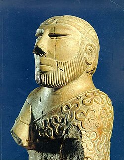
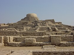
Sindh and surrounding areas contain the ruins of the Indus Valley Civilization. There are remnants of ancient cities and structures, with a notable example in Sindh being that of Mohenjo Daro. Built around 2500 BCE, it was one of the largest settlements of the ancient Indus civilization, with features such as standardized bricks, street grids, and covered sewerage systems. It was one of the world's earliest major cities, contemporaneous with the civilizations of ancient Egypt, Mesopotamia, Minoan Crete, and Caral-Supe. Mohenjo-daro was abandoned in the 19th century BCE as the Indus Valley Civilization declined, and the site was not rediscovered until the 1920s. Significant excavation has since been conducted at the site of the city, which was designated a UNESCO World Heritage Site in 1980. The site is currently threatened by erosion and improper restoration. A gradual drying of the region during the 3rd millennium BC may have been the initial stimulus for its urbanisation. Eventually it also reduced the water supply enough to cause the civilisation's demise and to disperse its population to the east.
During the Bronze Age, the territory of Sindh was known as Sindhu-Sauvīra, covering the lower Indus Valley, with its southern border being the Indian Ocean and its northern border being the Pañjāb around Multān. The capital of Sindhu-Sauvīra was named Roruka and Vītabhaya or Vītībhaya, and corresponds to the medieval Arohṛ and the modern-day Rohṛī. The Achaemenids conquered the region and established the satrapy of Hindush. The territory may have corresponded to the area covering the lower and central Indus basin (present day Sindh and the southern Punjab regions of Pakistan). Alternatively, some authors consider that Hindush may have been located in the Punjab. These areas remained under Persian control until the invasion by Alexander.
Alexander conquered parts of Sindh after Punjab for few years and appointed his general Peithon as governor. He constructed a harbour at the city of Patala in Sindh. Chandragupta Maurya fought Alexander's successor in the east, Seleucus I Nicator, when the latter invaded. In a peace treaty, Seleucus ceded all territories west of the Indus River and offered a marriage, including a portion of Bactria, while Chandragupta granted Seleucus 500 elephants.
Following a century of Mauryan rule which ended by 180 BC, the region came under the Indo-Greeks, followed by the Indo Scythians, who ruled with their capital at Minnagara. Later on, Sasanian rulers from the reign of Shapur I claimed control of the Sindh area in their inscriptions, known as Hind.
The local Rai dynasty emerged in Sindh and reigned for a period of 144 years, concurrent with the Huna invasions of North India. Aror was noted to be the capital. The Chach dynasty succeeded the Rai dynasty. Most of the information about its existence comes from the Chach Nama, a historical account of the Chach-Brahmin dynasty. After the empire's fall in 712, though the empire had ended, its dynasty's members administered parts of Sindh under the Umayyad Caliphate's Caliphal province of Sind.
Medieval era
After the death of the Islamic prophet Muhammad, the Arab expansion towards the east reached the Sindh region beyond Persia. The connection between the Sindh and Islam was established by the initial Muslim invasions during the Rashidun Caliphate. The first clash with the Rai kings of Sindh took place in 636 (15 AH) under Caliph Umar ibn al-Khattab with the governor of Bahrain, Uthman ibn Abu-al-Aas, dispatching naval expeditions against Thane, Bharuch and Debal. Al-Baladhuri states they were victorious at Debal but does not mention the results of other two raids. However, the Chach Nama states that the raiders of Debal were defeated and its governor killed the leader of the raids. These raids were thought to be triggered by a later pirate attack on Umayyad ships. Al-Baladhuri adds that this stopped any more incursions until the reign of Uthman. Al-Hakim ibn Jabalah al-Abdi, who attacked Makran in the year 649, was an early partisan of Ali ibn Abu Talib. During the caliphate of Ali, many Jats of Sindh (known in Arabic sources as Zuṭṭ) had come under the influence of Shi'ism with some even participating in the Battle of Camel and died fighting for Ali. Under the Arab Umayyads (661–750), many Shias sought asylum in the region of Sindh, to live in relative peace in the remote area. Ziyad Hindi is one of those refugees.
In 712, Mohammed Bin Qasim defeated the Chach dynasty and annexed it to the Umayyad Caliphate. This marked the beginning of Islam in the Indian subcontinent. The Habbari dynasty ruled much of Greater Sindh, as a semi-independent emirate from 854 to 1024. Beginning with the rule of 'Umar bin Abdul Aziz al-Habbari in 854, the region became semi-independent from the Abbasid Caliphate in 861, while continuing to nominally pledge allegiance to the Abbasid Caliph in Baghdad. The Habbaris ruled Sindh until they were defeated by Sultan Mahmud Ghaznavi in 1026, who then went on to destroy the old Habbari capital of Mansura, and annex the region to the Ghaznavid Empire, thereby ending Arab rule of Sindh.
The Soomra dynasty was a local Sindhi Muslim dynasty that ruled between early 11th century and the 14th century. Later chroniclers like Ali ibn al-Athir (c. late 12th c.) and Ibn Khaldun (c. late 14th c.) attributed the fall of Habbarids to Mahmud of Ghazni, lending credence to the argument of Hafif being the last Habbarid. The Soomras appear to have established themselves as a regional power in this power vacuum. The Ghurids and Ghaznavids continued to rule parts of Sindh, across the eleventh and early twelfth century, alongside Soomras. The precise delineations are not yet known but Sommrus were probably centered in lower Sindh. Some of them were adherents of Isma'ilism. One of their kings Shimuddin Chamisar had submitted to Iltutmish, the Sultan of Delhi, and was allowed to continue on as a vassal.

The Sammas overthrew the Soomras soon after 1335 and established the Sindh Sultanate. The last Soomra ruler took shelter with the governor of Gujarat, under the protection of Muhammad bin Tughluq, the sultan of Delhi. Mohammad bin Tughlaq made an expedition against Sindh in 1351 and died at Sondha, possibly in an attempt to restore the Soomras. With this, the Sammas became independent. The next sultan, Firuz Shah Tughlaq attacked Sindh in 1365 and 1367, unsuccessfully, but with reinforcements from Delhi he later obtained Banbhiniyo's surrender. For a period the Sammas were therefore subject to Delhi again. Later, as the Sultanate of Delhi collapsed they became fully independent. Jam Unar was the founder of Samma dynasty mentioned by Ibn Battuta. The Samma civilization contributed significantly to the evolution of the Indo-Islamic architectural style. The city of Thatta is famous for its necropolis of erstwhile royals, the Makli Necropolis, which covers 10 square km on the Makli Hill. The Sammas have left a mark on Sindh with magnificent structures in Thatta. They were later overthrown by the Turko-Mongol Arghuns in the late 15th century.
Modern era

In the late 16th century, Sindh was brought into the Mughal Empire by Akbar, himself born in the Sodha kingdom in Umerkot in Sindh. In 1591–1593, Akbar sent an army to conquer lower Sindh from the Tarkhan dynasty after defeating the last Tarkhan ruler, Mirza Jani Beg; Jani Beg and his son Mirza Ghazi Beg.
Mughal rule from their provincial capital of Thatta was to last in lower Sindh until the early 18th century, while upper Sindh was ruled by the indigenous Kalhora dynasty holding power, consolidating their rule from their capital of Khudabad, before shifting to Hyderabad from 1768 onwards.
The Talpurs succeeded the Kalhoras and four branches of the dynasty were established. One ruled lower Sindh from the city of Hyderabad, another ruled over upper Sindh from the city of Khairpur, a third ruled around the eastern city of Mirpur Khas, and a fourth was based in Tando Muhammad Khan. They were ethnically Baloch, and for most of their rule, they were subordinate to the Durrani Empire and were forced to pay tribute to them.
They ruled from 1783, until 1843, when they were in turn defeated by the British at the Battle of Miani and Battle of Dubbo. The northern Khairpur branch of the Talpur dynasty, however, continued to maintain a degree of sovereignty during British rule as the princely state of Khairpur, whose ruler elected to join the new Dominion of Pakistan in October 1947 as an autonomous region, before being fully amalgamated into West Pakistan in 1955.
British Raj

The British conquered Sindh in 1843. General Charles Napier is said to have reported victory to the Governor General with a one-word telegram, namely "Peccavi" – or "I have sinned" (Latin). The British had two objectives in their rule of Sindh: the consolidation of British rule and the use of Sindh as a market for British products and a source of revenue and raw materials. With the appropriate infrastructure in place, the British hoped to utilise Sindh for its economic potential. The British incorporated Sindh, some years later after annexing it, into the Bombay Presidency. Distance from the provincial capital, Bombay, led to grievances that Sindh was neglected in contrast to other parts of the Presidency. The merger of Sindh into Punjab province was considered from time to time but was turned down because of British disagreement and Sindhi opposition, both from Muslims and Hindus, to being annexed to Punjab.
Later, desire for a separate administrative status for Sindh grew. At the annual session of the Indian National Congress in 1913, a Sindhi Hindu put forward the demand for Sindh's separation from the Bombay Presidency on the grounds of Sindh's unique cultural character. This reflected the desire of Sindh's predominantly Hindu commercial class to free itself from competing with the more powerful Bombay's business interests. Meanwhile, Sindhi politics was characterised in the 1920s by the growing importance of Karachi and the Khilafat Movement. A number of Sindhi pirs, descendants of Sufi saints who had proselytised in Sindh, joined the Khilafat Movement, which propagated the protection of the Ottoman Caliphate, and those pirs who did not join the movement found a decline in their following. The pirs generated huge support for the Khilafat cause in Sindh. Sindh came to be at the forefront of the Khilafat Movement.
Although Sindh was less sectarian than other parts of India, the province's Muslim elite and emerging Muslim middle class demanded separation of Sindh from Bombay Presidency as a safeguard for their own interests. In this campaign, local Sindhi Muslims identified 'Hindu' with Bombay instead of Sindh. Sindhi Hindus were seen as representing the interests of Bombay instead of the majority of Sindhi Muslims. Sindhi Hindus, for the most part, opposed the separation of Sindh from Bombay. Although Sindh had a culture of religious syncretism, communal harmony and tolerance due to Sindh's strong Sufi culture in which both Sindhi Muslims and Sindhi Hindus partook, both the Muslim landed elite, waderas, and the Hindu commercial elements, banias, collaborated in oppressing the predominantly Muslim peasantry of Sindh who were economically exploited. Sindhi Muslims eventually demanded the separation of Sindh from the Bombay Presidency, a move opposed by Sindhi Hindus.
In Sindh's first provincial election after its separation from Bombay in 1936, economic interests were an essential factor of politics informed by religious and cultural issues. Due to British policies, much land in Sindh was transferred from Muslim to Hindu hands over the decades. Religious tensions rose in Sindh over the Sukkur Manzilgah issue where Muslims and Hindus disputed over an abandoned mosque in proximity to an area sacred to Hindus. The Sindh Muslim League exploited the issue and agitated for the return of the mosque to Muslims. Consequentially, a thousand members of the Muslim League were imprisoned. Eventually, due to panic the government restored the mosque to Muslims. The separation of Sindh from Bombay Presidency triggered Sindhi Muslim nationalists to support the Pakistan Movement. Even while the Punjab and North-West Frontier Province were ruled by parties hostile to the Muslim League, Sindh remained loyal to Jinnah. Although the prominent Sindhi Muslim nationalist G. M. Syed left the All India Muslim League in the mid-1940s and his relationship with Jinnah never improved, the overwhelming majority of Sindhi Muslims supported the creation of Pakistan, seeing in it their deliverance. Sindhi support for the Pakistan Movement arose from the desire of the Sindhi Muslim business class to drive out their Hindu competitors. The Muslim League's rise to becoming the party with the strongest support in Sindh was in large part linked to its winning over of the religious pir families. Although the Muslim League had previously fared poorly in the 1937 elections in Sindh, when local Sindhi Muslim parties won more seats, the Muslim League's cultivation of support from local pirs in 1946 helped it gain a foothold in the province, it didn't take long for the overwhelming majority of Sindhi Muslims to campaign for the creation of Pakistan.
Partition (1947)
In 1947, violence did not constitute a major part of the Sindhi partition experience, unlike in Punjab. There were very few incidents of violence on Sindh, in part due to the Sufi-influenced culture of religious tolerance and in part that Sindh was not divided and was instead made part of Pakistan in its entirety. Sindhi Hindus who left generally did so out of a fear of persecution, rather than persecution itself, because of the arrival of Muslim refugees from India. Sindhi Hindus differentiated between the local Sindhi Muslims and the migrant Muslims from India. A large number of Sindhi Hindus travelled to India by sea, to the ports of Bombay, Porbandar, Veraval and Okha.
Demographics
| Indicator | Value |
|---|---|
| Urban population | 53.97% |
| Rural population | 46.03% |
| Population growth rate | 2.57% |
| Gender ratio (male per 100 female) | 108.76 |
| Economically active population | 22.75% (old data)[clarification needed] |
Population
| Year | Pop. | ±% |
|---|---|---|
| 1872 | 2,322,765 | — |
| 1881 | 2,542,976 | +9.5% |
| 1891 | 3,003,711 | +18.1% |
| 1901 | 3,410,223 | +13.5% |
| 1911 | 3,737,223 | +9.6% |
| 1921 | 3,472,508 | −7.1% |
| 1931 | 4,114,253 | +18.5% |
| 1941 | 4,840,795 | +17.7% |
| 1951 | 6,047,748 | +24.9% |
| 1961 | 8,367,065 | +38.4% |
| 1972 | 14,155,909 | +69.2% |
| 1981 | 19,028,666 | +34.4% |
| 1998 | 29,991,161 | +57.6% |
| 2017 | 47,854,510 | +59.6% |
| 2023 | 55,696,147 | +16.4% |
| Source: Census in Pakistan, Census of British Raj |
Sindh has the second highest Human Development Index out of all of Pakistan's provinces at 0.628. The 2023 Census of Pakistan indicated a population of 55.7 million.
As per a 2025 Dawn News report, based on data compiled by research organisation Population Council, UK Aid and the United Nations Population, Sindh had an annual growth rate of 2.57%. According to demographic projections, if the province’s current total fertility rate of 3.6 children per woman remains unchanged, Sindh's population could more than double to approximately 111 million by 2050.
Religion
- Islam (90.0%)
- Hinduism (8.81%)
- Christianity (0.98%)
- Ahmaddiya (0.03%)
- Sikhism (0.01%)
- Zoroastrianism (0.00%)
- Other (0.07%)
Islam in Sindh has a long history, starting with the capture of Sindh by Muhammad Bin Qasim in 712. Over time, the majority of the population in Sindh converted to Islam, especially in rural areas. Today, Muslims make up 90% of the population, and are more dominant in urban than rural areas. Islam in Sindh has a strong Sufi ethos with numerous Muslim saints and mystics, such as the Sufi poet Shah Abdul Latif Bhittai, having lived in Sindh historically. One popular legend that highlights the strong Sufi presence in Sindh is that 125,000 Sufi saints and mystics are buried on Makli Hill near Thatta. The development of Sufism in Sindh was similar to the development of Sufism in other parts of the Muslim world. In the sixteenth century two Sufi tareeqat (orders) – Qadria and Naqshbandia – were introduced in Sindh. Sufism continues to play an important role in the daily lives of Sindhis.
In 1941, the last census conducted prior to the partition of India, the total population of Sindh was 4,840,795 out of which 3,462,015 (71.5%) were Muslims, 1,279,530 (26.4%) were Hindus and the remaining were Tribals, Sikhs, Christians, Parsis, Jains, Jews, and Buddhists.
Sindh also has Pakistan's highest percentage of Hindus overall, accounting for 8.8% of the population, roughly around 4.9 million people, and 13.3% of the province's rural population as per 2023 Pakistani census report. These numbers also include the scheduled caste population, which stands at 1.7% of the total in Sindh (or 3.1% in rural areas), and is believed to have been under-reported, with some community members instead counted under the main Hindu category. Although, Pakistan Hindu Council claimed that there are 6,842,526 Hindus living in Sindh Province covering around 14.29% of the region's population. Umerkot district in the Thar Desert is Pakistan's only Hindu-majority district. The Shri Ramapir Temple in Tandoallahyar whose annual festival is the second largest Hindu pilgrimage in Pakistan is in Sindh. Sindh is also the only province in Pakistan to have a separate law for governing Hindu marriages.
2020 community estimates indicated the Sikh population in Sindh stood at approximately 10,000, while the 2023 census indicated a population of 5,182 Sikhs.
| Religious group | 1872 | 1881 | 1891 | 1901 | 1911 | 1921 | 1931 | 1941 | 1951 | 1998 | 2017 | 2023 | ||||||||||||
|---|---|---|---|---|---|---|---|---|---|---|---|---|---|---|---|---|---|---|---|---|---|---|---|---|
| Pop. | % | Pop. | % | Pop. | % | Pop. | % | Pop. | % | Pop. | % | Pop. | % | Pop. | % | Pop. | % | Pop. | % | Pop. | % | Pop. | % | |
| Islam | 1,712,266 | 78.1% | 1,989,630 | 78.24% | 2,318,180 | 77.18% | 2,609,337 | 76.52% | 2,822,756 | 75.53% | 2,562,700 | 73.8% | 3,017,377 | 73.34% | 3,462,015 | 71.52% | 5,535,645 | 91.53% | 27,796,814 | 91.32% | 43,234,107 | 90.34% | 50,126,428 | 90.09% |
| Hinduism | 475,848 | 21.7% | 544,848 | 21.43% | 674,371 | 22.45% | 787,683 | 23.1% | 877,313 | 23.47% | 876,629 | 25.24% | 1,055,119 | 25.65% | 1,279,530 | 26.43% | 482,560 | 7.98% | 2,280,842 | 7.49% | 4,176,986 | 8.73% | 4,901,407 | 8.81% |
| Christianity | 3,329 | 0.15% | 6,082 | 0.24% | 7,768 | 0.26% | 7,825 | 0.23% | 10,917 | 0.29% | 11,734 | 0.34% | 15,152 | 0.37% | 20,304 | 0.42% | 22,601 | 0.37% | 294,885 | 0.97% | 408,301 | 0.85% | 546,968 | 0.98% |
| Zoroastrianism | 870 | 0.04% | 1,063 | 0.04% | 1,534 | 0.05% | 2,000 | 0.06% | 2,411 | 0.06% | 2,913 | 0.08% | 3,537 | 0.09% | 3,841 | 0.08% | 5,046 | 0.08% | —N/a | —N/a | —N/a | —N/a | 1,763 | 0.003% |
| Buddhism | 67 | 0.003% | 9 | 0% | 2 | 0% | 0 | 0% | 21 | 0.001% | 41 | 0.001% | 53 | 0.001% | 111 | 0.002% | 670 | 0.01% | —N/a | —N/a | —N/a | —N/a | —N/a | —N/a |
| Judaism | 35 | 0.002% | 153 | 0.01% | 210 | 0.01% | 428 | 0.01% | 595 | 0.02% | 671 | 0.02% | 985 | 0.02% | 1,082 | 0.02% | —N/a | —N/a | —N/a | —N/a | —N/a | —N/a | —N/a | —N/a |
| Jainism | —N/a | —N/a | 1,191 | 0.05% | 923 | 0.03% | 921 | 0.03% | 1,349 | 0.04% | 1,534 | 0.04% | 1,144 | 0.03% | 3,687 | 0.08% | —N/a | —N/a | —N/a | —N/a | —N/a | —N/a | —N/a | —N/a |
| Sikhism | —N/a | —N/a | —N/a | —N/a | 720 | 0.02% | —N/a | —N/a | 12,339 | 0.33% | 8,036 | 0.23% | 19,172 | 0.47% | 32,627 | 0.67% | —N/a | —N/a | —N/a | —N/a | —N/a | —N/a | 5,182 | 0.01% |
| Tribal | —N/a | —N/a | —N/a | —N/a | —N/a | —N/a | —N/a | —N/a | 9,224 | 0.25% | 8,186 | 0.24% | 204 | 0% | 37,598 | 0.78% | —N/a | —N/a | —N/a | —N/a | —N/a | —N/a | —N/a | —N/a |
| Ahmadiyya | —N/a | —N/a | —N/a | —N/a | —N/a | —N/a | —N/a | —N/a | —N/a | —N/a | —N/a | —N/a | —N/a | —N/a | —N/a | —N/a | —N/a | —N/a | 43,524 | 0.14% | 21,661 | 0.05% | 18,266 | 0.03% |
| Others | 0 | 0% | 0 | 0% | 3 | 0% | 2,029 | 0.06% | 298 | 0.01% | 64 | 0.002% | 1,510 | 0.04% | 0 | 0% | 1,226 | 0.02% | 23,828 | 0.08% | 13,455 | 0.03% | 38,395 | 0.07% |
| Total Responses | 2,192,415 | 94.39% | 2,542,976 | 100% | 3,003,711 | 100% | 3,410,223 | 100% | 3,737,223 | 100% | 3,472,508 | 100% | 4,114,253 | 100% | 4,840,795 | 100% | 6,047,748 | 99.89% | 30,439,893 | 100% | 47,854,510 | 100% | 55,638,409 | 99.9% |
| Total Population | 2,322,765 | 100% | 2,542,976 | 100% | 3,003,711 | 100% | 3,410,223 | 100% | 3,737,223 | 100% | 3,472,508 | 100% | 4,114,253 | 100% | 4,840,795 | 100% | 6,054,474 | 100% | 30,439,893 | 100% | 47,854,510 | 100% | 55,696,147 | 100% |
Languages
- Sindhi (60.1%)
- Urdu (22.3%)
- Pashto (5.31%)
- Punjabi (4.07%)
- Balochi (2.17%)
- Saraiki (1.64%)
- Hindko (1.49%)
- Others (2.88%)

According to the 2023 census, the most widely spoken language in the province is Sindhi, the first language of 33,462,299 60% of the population. It is followed by Urdu 12,409,745 (22%), then Pashto 2,955,893 (5.3%), Punjabi 2,265,471 (4.1%), Balochi 1,208,147 (2.2%), Saraiki 913,418 (1.6%), and Hindko 830,581 (1.5), Brahui 265,769, Mewati 57,059, Kashmiri 53,249, Balti 27,193, Shina 22,273, Koshistani 14,885, 777 Kalasha and others are 1,151,650, Other minority languages include Kutchi, Gujarati, Aer, Bagri, Bhaya, Brahui, Dhatki, Ghera, Goaria, Gurgula, Jadgali, Jandavra, Jogi, Kabutra, Kachi Koli, Parkari Koli, Wadiyari Koli, Loarki, Marwari, Sansi, and Vaghri.
Geography and nature

Sindh is in the western corner of South Asia, bordering the Iranian plateau in the west. Geographically it is the third largest province of Pakistan, stretching about 579 kilometres (360 mi) from north to south and 442 kilometres (275 mi) (extreme) or 281 kilometres (175 mi) (average) from east to west, with an area of 140,915 square kilometres (54,408 sq mi) of Pakistani territory. Sindh is bounded by the Thar Desert to the east, the Kirthar Mountains to the west and the Arabian Sea and Rann of Kutch to the south. In the centre is a fertile plain along the Indus River.
Sindh is divided into three main geographical regions: Siro ("upper country"), aka Upper Sindh, which is above Sehwan; Vicholo ("middle country"), or Middle Sindh, from Sehwan to Hyderabad; and Lāṟu ("sloping, descending country"), or Lower Sindh, mostly consisting of the Indus Delta below Hyderabad.
Flora

The province is mostly arid with scant vegetation except for the irrigated Indus Valley. The dwarf palm, Acacia rupestris (kher), and Tecomella undulata (lohirro) trees are typical of the western hill region. In the Indus valley, the Acacia nilotica (babul) (babbur) is the most dominant and occurs in thick forests along the Indus banks. The Azadirachta indica (neem) (nim), Zizyphys vulgaris (bir) (ber), Tamarix orientalis (jujuba lai) and Capparis aphylla (kirir) are among the more common trees.
Mango, date palms and the more recently introduced banana, guava, orange and chiku are the typical fruit-bearing trees. The coastal strip and the creeks abound in semi-aquatic and aquatic plants and the inshore Indus delta islands have forests of Avicennia tomentosa (timmer) and Ceriops candolleana (chaunir) trees. Water lilies grow in abundance in the numerous lakes and ponds, particularly in the lower Sindh region.[citation needed]
Fauna

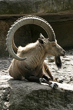
Among the wild animals, the Sindh ibex (sareh), blackbuck, wild sheep (Urial or gadh) and wild bear are found in the western rocky range. The leopard is now rare and the Asiatic cheetah extinct. The Pirrang (large tiger cat or fishing cat) of the eastern desert region is also disappearing. Deer occur in the lower rocky plains and in the eastern region, as do the Striped hyena (charakh), jackal, fox, porcupine, common gray mongoose and hedgehog. The Sindhi phekari, red lynx or Caracal cat, is found in some areas. Phartho (hog deer) and wild bear occur, particularly in the central inundation belt. There are bats, lizards and reptiles, including the cobra, lundi (viper) and the mysterious Sindh krait of the Thar region, which is supposed to suck the victim's breath in his sleep. Some unusual sightings of Asian cheetah occurred in 2003 near the Balochistan border in Kirthar Mountains. The rare Houbara bustard finds Sindh's warm climate suitable to rest and mate. Unfortunately, it is hunted by locals and foreigners.
Crocodiles are rare and inhabit only the backwaters of the Indus, eastern Nara channel and Karachi backwater. Besides a large variety of marine fish, the plumbeous dolphin, the beaked dolphin, rorqual or blue whale and skates frequent the seas along the Sindh coast. The Pallo (Sable fish), a marine fish, ascends the Indus annually from February to April to spawn. The Indus river dolphin is among the most endangered species in Pakistan and is found in the part of the Indus river in northern Sindh. Hog deer and wild bear occur, particularly in the central inundation belt.
Although Sindh has a semi arid climate, through its coastal and riverine forests, its huge fresh water lakes and mountains and deserts, Sindh supports a large amount of varied wildlife. Due to the semi-arid climate of Sindh the left out forests support an average population of jackals and snakes. The national parks established by the Government of Pakistan in collaboration with many organizations such as World Wide Fund for Nature and Sindh Wildlife Department support a huge variety of animals and birds. The Kirthar National Park in the Kirthar range spreads over more than 3000 km2 of desert, stunted tree forests and a lake. The KNP supports Sindh ibex, wild sheep (urial) and black bear along with the rare leopard. There are also occasional sightings of The Sindhi phekari, ped lynx or Caracal cat. There is a project to introduce tigers and Asian elephants too in KNP near the huge Hub Dam Lake. Between July and November when the monsoon winds blow onshore from the ocean, giant olive ridley turtles lay their eggs along the seaward side. The turtles are protected species. After the mothers lay and leave them buried under the sands the SWD and WWF officials take the eggs and protect them until they are hatched to keep them from predators.
Climate

Sindh lies in a tropical to subtropical region; it is hot in the summer and mild to warm in winter. Temperatures frequently rise above 46 °C (115 °F) between May and August, and the minimum average temperature of 2 °C (36 °F) occurs during December and January in the northern and higher elevated regions. The annual rainfall averages about seven inches, falling mainly during July and August. The southwest monsoon wind begins in mid-February and continues until the end of September, whereas the cool northerly wind blows during the winter months from October to January.
Sindh lies between the two monsoons—the southwest monsoon from the Indian Ocean and the northeast or retreating monsoon, deflected towards it by the Himalayan mountains—and escapes the influence of both. The region's scarcity of rainfall is compensated by the inundation of the Indus twice a year, caused by the spring and summer melting of Himalayan snow and by rainfall in the monsoon season.
Sindh is divided into three climatic regions: Siro (the upper region, centred on Jacobabad), Wicholo (the middle region, centred on Hyderabad), and Lar (the lower region, centred on Karachi). The thermal equator passes through upper Sindh, where the air is generally very dry. Central Sindh's temperatures are generally lower than those of upper Sindh but higher than those of lower Sindh. Dry hot days and cool nights are typical during the summer. Central Sindh's maximum temperature typically reaches 43–44 °C (109–111 °F). Lower Sindh has a damper and humid maritime climate affected by the southwestern winds in summer and northeastern winds in winter, with lower rainfall than Central Sindh. Lower Sindh's maximum temperature reaches about 35–38 °C (95–100 °F). In the Kirthar range at 1,800 m (5,900 ft) and higher at Gorakh Hill and other peaks in Dadu District, temperatures near freezing have been recorded and brief snowfall is received in the winters.
Major cities
| List of major cities in Sindh | ||||
|---|---|---|---|---|
| Rank | City | District(s) | Population | Image |
| 1 | Karachi | Nazimabad, Orangi, Gulshan, Korangi, Malir, Keamari, Karachi | 18,868,021 | |
| 2 | Hyderabad | Hyderabad | 1,921,275 | |
| 3 | Sukkur | Sukkur | 563,851 | |
| 4 | Larkana | Larkana | 551,716 | |
| 5 | Benazirabad | Shaheed Benazirabad | 363,138 | |
| 6 | Kotri | Jamshoro | 106,615 | |
| 7 | Mirpur Khas | Mirpur Khas | 267,833 | |
| 8 | Shikarpur | Shikarpur | 204,938 | |
| 9 | Jacobabad | Jacobabad | 219,315 | |
| 10 | Khairpur | Khairpur | 191,044 | |
| Source: Pakistan Census 2023 | ||||
| This is a list of city proper populations and does not indicate metro populations. |
Government
Sindh province


The Provincial Assembly of Sindh is a unicameral and consists of 168 seats, of which 5% are reserved for non-Muslims and 17% for women. The provincial capital of Sindh is Karachi. The provincial government is led by Chief Minister who is directly elected by the popular and landslide votes; the Governor serves as a ceremonial representative nominated and appointed by the President of Pakistan. The administrative boss of the province who is in charge of the bureaucracy is the Chief Secretary Sindh, who is appointed by the Prime Minister of Pakistan. Most of the influential Sindhi tribes in the province are involved in Pakistan's politics.
In addition, Sindh's politics leans towards the left-wing and its political culture serves as a dominant place for the left-wing spectrum in the country. The province's trend towards the Pakistan Peoples Party (PPP) and away from the Pakistan Muslim League (N) can be seen in nationwide general elections, in which Sindh is a stronghold of the PPP. The PML(N) has a limited support due to its centre-right agenda.
In metropolitan cities such as Karachi and Hyderabad, the MQM (another party of the left with the support of Muhajirs) has a considerable vote bank and support. Minor leftist parties such as the People's Movement also found support in rural areas of the province.
Divisions
In 2008, after the public elections, the new government decided to restore the structure of Divisions of all provinces. In Sindh after the lapse of the Local Governments Bodies term in 2010 the Divisional Commissioners system was to be restored.
In July 2011, following excessive violence in the city of Karachi and after the political split between the ruling PPP and the majority party in Sindh, the MQM and after the resignation of the MQM Governor of Sindh, PPP and the Government of Sindh decided to restore the commissionerate system in the province. As a consequence, the five divisions of Sindh were restored – namely Karachi, Hyderabad, Sukkur, Mirpurkhas and Larkana with their respective districts. Subsequently, a new division was added in Sindh, the Nawab Shah/Shaheed Benazirabad division.
Karachi district has been de-merged into its five original constituent districts: Karachi East, Karachi West, Karachi Central, Karachi South and Malir. Recently Korangi has been upgraded to the status of the sixth district of Karachi. These six districts form the Karachi Division now. In 2020, the Kemari District was created after splitting Karachi West District. Currently the Sindh government is planning to divide the Tharparkar district into Tharparkar and Chhachro districts.
Districts

Tehsils
In Sindh, talukas are equivalent to the tehsils used elsewhere in the country.
| Tehsil | Area (km²) | Population (2023) | Density (ppl/km²) (2023) | Districts | Divisions |
|---|---|---|---|---|---|
| Badin Tehsil | 1,816 | 490,386 | 270.04 | Badin District | Hyderabad Division |
| Matli Tehsil | 1,143 | 471,100 | 412.16 | ||
| Shaheed Fazil Rahu Tehsil | 1,642 | 374,854 | 228.29 | ||
| Talhar Tehsil | 569 | 184,206 | 323.74 | ||
| Tando Bago Tehsil | 1,688 | 426,535 | 252.69 | ||
| Jati Tehsil | 3,489 | 214,710 | 61.54 | Sujawal District | |
| Kharo Chan Tehsil | 778 | 11,403 | 14.66 | ||
| Mirpur Bathoro Tehsil | 698 | 231,735 | 332 | ||
| Shah Bandar Tehsil | 3,074 | 168,911 | 54.95 | ||
| Sujawal Tehsil | 746 | 212,533 | 284.90 | ||
| Ghorabari Tehsil | 1,018 | 198,920 | 195.40 | Thatta District | |
| Keti Bunder | 771 | 63,217 | 81.99 | ||
| Mirpur Sakro Tehsil | 2,958 | 376,078 | 127.14 | ||
| Thatta Tehsil | 3,823 | 444,976 | 116.39 | ||
| Dadu Tehsil | 846 | 508,607 | 601.19 | Dadu District | |
| Johi Tehsil | 3,509 | 333,179 | 94.95 | ||
| Khairpur Nathan Shah Tehsil | 2,583 | 379,975 | 147.11 | ||
| Mehar Tehsil | 928 | 520,559 | 560.95 | ||
| Hyderabad City Tehsil | 43 | 778,132 | 18,096.09 | Hyderabad District | |
| Hyderabad Tehsil | 711 | 511,265 | 719.08 | ||
| Latifabad Tehsil | 204 | 800,983 | 3,926.39 | ||
| Qasimabad Tehsil | 35 | 342,160 | 9,776.00 | ||
| Kotri Tehsil | 1,051 | 472,003 | 244.10 | Jamshoro District | |
| Sehwan Tehsil | 2,160 | 322,011 | 149.08 | ||
| Manjhand Tehsil | 2,303 | 161,794 | 70.28 | ||
| Thana Bulla Khan Tehsil | 5,690 | 161,500 | 28.39 | ||
| Hala Tehsil | 488 | 286,155 | 586.38 | Matiari District | |
| Matiari Tehsil | 568 | 377,945 | 665.40 | ||
| Saeedabad Tehsil | 361 | 185,283 | 513.25 | ||
| Chamber Tehsil | 483 | 233,424 | 483.28 | Tando Allahyar District | |
| Jhando Mari Tehsil | 626 | 266,665 | 425.98 | ||
| Tando Allahyar Tehsil | 445 | 421,923 | 948.14 | ||
| Bulri Shah Karim Tehsil | 770 | 247,027 | 320.81 | Tando Muhammad Khan District | |
| Tando Ghulam Hyder Tehsil | 390 | 206,665 | 529.91 | ||
| Tando Muhammad Khan Tehsil | 263 | 272,427 | 1,035.84 | ||
| Gulberg Town | 14 | 613,724 | 43,837.43 | Karachi Central District | Karachi Division |
| Liaquatabad Town | 6 | 547,706 | 91,284.33 | ||
| New Karachi Town | 18 | 1,165,742 | 64,763.44 | ||
| North Nazimabad Town | 23 | 922,413 | 40,104.91 | ||
| Nazimabad | 8 | 572,740 | 71,592.50 | ||
| Jamshed Town | 11 | 656,014 | 59,637.64 | Karachi East District | |
| Ferozabad | 20 | 1,167,692 | 58,384.60 | ||
| Gulshan-e-Iqbal | 29 | 979,502 | 33,775.93 | ||
| Gulzar-e-Hijri | 79 | 1,118,534 | 14,158.66 | ||
| Lyari Town | 6 | 949,878 | 158,313.00 | Karachi South District | |
| Saddar Town | 35 | 159,363 | 4,553.23 | ||
| Aram Bagh | 4 | 237,224 | 59,306.00 | ||
| Civil Line | 73 | 480,480 | 6,581.92 | ||
| Garden | 4 | 502,819 | 125,704.75 | ||
| Orangi Town | 9 | 596,919 | 66,324.33 | Karachi West District | |
| Manghopir | 342 | 1,081,753 | 3,163.02 | ||
| Mominabad | 19 | 1,000,708 | 52,668.84 | ||
| Korangi Town | 59 | 1,363,992 | 23,118.51 | Korangi District | |
| Landhi Town | 19 | 681,294 | 35,857.58 | ||
| Shah Faisal Town | 21 | 641,894 | 30,566.38 | ||
| Model Colony | 9 | 441,791 | 49,087.89 | ||
| Bin Qasim | 447 | 322,915 | 722.40 | Malir District | |
| Gadap Town | 1,104 | 100,351 | 90.90 | ||
| Airport | 41 | 254,370 | 6,204.15 | ||
| Ibrahim Hyderi | 97 | 1,341,638 | 13,831.32 | ||
| Murad Memon Goth | 195 | 376,987 | 1,933.27 | ||
| Shah Mureed | 276 | 35,987 | 130.39 | ||
| Keamari Town | 50 | 451,801 | 9,036.02 | Keamari District | |
| Baldia Town | 34 | 948,597 | 27,899.91 | ||
| S.I.T.E. Town | 25 | 449,120 | 17,964.80 | ||
| Maripur | 450 | 218,933 | 486.52 | ||
| Garhi Khairo Tehsil | 733 | 193,297 | 263.72 | Jacobabad District | Larkana Division |
| Jacobabad Tehsil | 664 | 447,647 | 674.11 | ||
| Thul Tehsil | 1,301 | 533,153 | 409.81 | ||
| Kandhkot Tehsil | 654 | 407,592 | 623.23 | Kashmore District | |
| Kashmore Tehsil | 1,262 | 487,601 | 386.37 | ||
| Tangwani Tehsil | 664 | 338,764 | 510.19 | ||
| Bakrani Tehsil | 425 | 275,268 | 647.69 | Larkana District | |
| Dokri Tehsil | 412 | 257,394 | 624.74 | ||
| Larkana Tehsil | 549 | 873,868 | 1,591.74 | ||
| Ratodero Tehsil | 562 | 377,923 | 672.46 | ||
| Mirokhan Tehsil | 374 | 182,461 | 487.92 | Qambar Shahdadkot District | |
| Nasirabad Tehsil | 309 | 174,708 | 565.47 | ||
| Qambar Tehsil | 2,260 | 448,990 | 198.67 | ||
| Qubo Saeed Khan Tehsil | 1,033 | 99,308 | 96.13 | ||
| Shahdadkot Tehsil | 419 | 225,086 | 537.53 | ||
| Sijawal Junejo Tehsil | 385 | 130,635 | 339.31 | ||
| Warah Tehsil | 695 | 253,681 | 365.01 | ||
| Garhi Yasin Tehsil | 971 | 333,289 | 343.24 | Shikarpur District | |
| Khanpur Tehsil | 629 | 331,219 | 526.58 | ||
| Lakhi Tehsil | 351 | 300,490 | 856.10 | ||
| Shikarpur Tehsil | 561 | 421,332 | 751.04 | ||
| Daharki Tehsil | 2,088 | 335,145 | 160.51 | Ghotki District | Sukkur Division |
| Ghotki Tehsil | 763 | 540,939 | 708.96 | ||
| Khan Garh Tehsil (Khanpur) | 1,986 | 162,318 | 81.73 | ||
| Mirpur Mathelo Tehsil | 593 | 350,647 | 591.31 | ||
| Ubauro Tehsil | 653 | 383,560 | 587.38 | ||
| Faiz Ganj Tehsil | 946 | 243,254 | 257.14 | Khairpur District | |
| Gambat Tehsil | 582 | 286,129 | 491.63 | ||
| Khairpur Tehsil | 585 | 465,233 | 795.27 | ||
| Kingri Tehsil | 531 | 370,304 | 697.37 | ||
| Kot Diji Tehsil | 520 | 385,872 | 742.06 | ||
| Nara Tehsil | 11,611 | 173,968 | 14.98 | ||
| Sobho Dero Tehsil | 504 | 293,160 | 581.67 | ||
| Thari Mirwah Tehsil | 631 | 379,615 | 601.61 | ||
| New Sukkur Tehsil | 109 | 356,473 | 3,270.39 | Sukkur District | |
| Pano Akil Tehsil | 1,042 | 457,078 | 438.65 | ||
| Rohri Tehsil | 807 | 421,500 | 522.30 | ||
| Salehpat Tehsil | 2,957 | 137,738 | 46.58 | ||
| Sukkur Tehsil | 250 | 267,108 | 1,068.43 | ||
| Bhiria Tehsil | 488 | 330,308 | 676.86 | Naushahro Feroze District | Shaheed Benazirabad Division |
| Kandiaro Tehsil | 771 | 356,506 | 462.39 | ||
| Mehrabpur Tehsil | 361 | 273,764 | 758.35 | ||
| Moro Tehsil | 609 | 408,148 | 670.19 | ||
| Naushahro Feroze Tehsil | 717 | 408,356 | 569.53 | ||
| Kazi Ahmed Tehsil | 972 | 402,834 | 414.44 | Shaheed Benazirabad District | |
| Daur Tehsil (2004) | 2,210 | 532,621 | 241.00 | ||
| Nawabshah Tehsil (1907) | 435 | 481,978 | 1,108.00 | ||
| Sakrand Tehsil (1858) | 885 | 427,669 | 483.24 | ||
| Jam Nawaz Ali Tehsil | 440 | 171,598 | 390.00 | Sanghar District | |
| Khipro Tehsil | 5,933 | 366,748 | 61.81 | ||
| Sanghar Tehsil | 2,118 | 482,560 | 227.84 | ||
| Shahdadpur Tehsil | 890 | 525,164 | 590.07 | ||
| Sinjhoro Tehsil | 907 | 354,709 | 391.08 | ||
| Tando Adam Khan Tehsil | 440 | 407,686 | 926.56 | ||
| Digri Tehsil | 572 | 234,578 | 410.10 | Mirpur Khas District | Mirpur Khas Division |
| Hussain Bux Mari Tehsil | 209 | 172,143 | 823.70 | ||
| Jhuddo Tehsil | 363 | 230,285 | 634.39 | ||
| Kot Ghulam Muhammad Tehsil | 762 | 310,142 | 407.01 | ||
| Mirpur Khas Tehsil | 24 | 287,802 | 11,991.75 | ||
| Shujabad Tehsil | 396 | 185,654 | 468.82 | ||
| Sindhri Tehsil | 599 | 260,782 | 435.36 | ||
| Chachro Tehsil | 3,386 | 371,769 | 109.80 | Tharparkar District | |
| Dahli Tehsil | 2,126 | 326,034 | 153.36 | ||
| Diplo Tehsil | 2,872 | 163,119 | 56.80 | ||
| Kaloi Tehsil | 922 | 129,677 | 140.65 | ||
| Islamkot Tehsil | 3,515 | 265,643 | 75.57 | ||
| Mithi Tehsil | 2,954 | 239,091 | 80.94 | ||
| Nagarparkar Tehsil | 3,862 | 283,074 | 73.30 | ||
| Kunri Tehsil | 585 | 237,063 | 405.24 | Umerkot District | |
| Pithoro Tehsil | 855 | 130,383 | 152.49 | ||
| Samaro Tehsil | 959 | 184,051 | 191.92 | ||
| Umerkot Tehsil | 3,209 | 608,334 | 189.57 |
Lower-level subdivisions
Supervisory tapas correspond to the kanungo circles used elsewhere in the country, tapas correspond with the patwar circles used in other provinces, and dehs are equivalent to the mouzas used elsewhere.
Towns and villages
Economy


Education


| Year | Literacy rate |
|---|---|
| 1972 | 60.77 |
| 1981 | 37.5% |
| 1998 | 45.29% |
| 2017 | 54.57% |
| 2023 | 57.54% |
Universities
Other major public and private educational institutes in Sindh include:
- Adamjee Government Science College
- Aga Khan University
- APIIT
- Applied Economics Research Centre
- Bahria University
- Baqai Medical University
- Chandka Medical College Larkana
- Cadet College Petaro
- College of Digital Sciences
- College of Physicians & Surgeons Pakistan
- D. J. Science College
- Dawood University of Engineering & Technology
- Defence Authority Degree College for Men
- Dow International Medical College
- Dow University of Health Sciences
- Fatima Jinnah Dental College
- Federal Urdu University
- GBELS Dourai Mahar Taluka Daur Distt: Shaheed Benazirabad
- Ghulam Muhammad Mahar Medical College Sukkur
- Government College for Men Nazimabad
- Government College Hyderabad
- Government College of Commerce & Economics
- Government College of Technology, Karachi
- Government Degree College Matiari
- Government High School Ranipur
- Government Islamia Science College Sukkur
- Government Muslim Science College Hyderabad
- Government National College (Karachi)
- Greenwich University (Karachi)
- Hamdard University
- Hussain Ebrahim Jamal Research Institute of Chemistry
- Imperial Science College Nawabshah
- Indus Valley Institute of Art and Architecture
- Institute of Business Administration, Karachi
- Institute of Business Administration, Sukkar
- Institute of Business Management
- Institute of Industrial Electronics Engineering
- Institute of Sindhology
- Iqra University
- Islamia Science College (Karachi)
- Isra University Hyderabad
- Jinnah Medical & Dental College
- Jinnah Polytechnic Institute
- Jinnah Post Graduate Medical Centre
- Jinnah University for Women
- KANUPP Institute of Nuclear Power Engineering
- Karachi Institute of Economics and Technology
- Karachi School of Business and Leadership
- Liaquat University of Medical & Health Sciences
- Mehran University of Engineering and Technology
- Mohammad Ali Jinnah University
- National Academy of Performing Arts
- National University of Computer and Emerging Sciences
- National University of Modern Languages
- National University of Sciences and Technology
- NED University of Engineering and Technology
- Ojha Institute of Chest Diseases
- PAF Institute of Aviation Technology
- TES Public School, Daur
- Pakistan Navy Engineering College
- Pakistan Shipowners' College
- Pakistan Steel Cadet College
- Peoples Medical College for Girls Nawabshah
- PIA Training Centre Karachi
- Provincial Institute of Teachers Education Nawabshah
- Public School Hyderabad
- Quaid-e-Awam University of Engineering, Science and Technology, Nawabshah
- Rana Liaquat Ali Khan Government College of Home Economics
- Saint Patrick's College, Karachi
- Shah Abdul Latif Bhitai University
- Shaheed Benazir Bhutto Medical College
- Shaheed Zulfiqar Ali Bhutto Institute of Science and Technology
- Sindh Agriculture University
- Sindh Medical College
- Superior College of Science Hyderabad
- Sindh Muslim Law College
- Sir Syed Government Girls College
- Sir Syed University of Engineering and Technology
- St. Joseph's College
- Textile Institute of Pakistan
- University of Karachi
- University of Sindh
- Usman Institute of Technology
- Ziauddin Medical University
Culture


The rich culture, art and architectural landscape of Sindh have fascinated historians. The culture, folktales, art and music of Sindh form a mosaic of human history.
Cultural heritage

The work of Sindhi artisans was sold in ancient markets of Damascus, Baghdad, Basra, Istanbul, Cairo and Samarkand. Referring to the lacquer work on wood locally known as Jandi, T. Posten (an English traveller who visited Sindh in the early 19th century) asserted that the articles of Hala could be compared with exquisite specimens of China. Technological improvements such as the spinning wheel (charkha) and treadle (pai-chah) in the weaver's loom were gradually introduced and the processes of designing, dyeing and printing by block were refined. The refined, lightweight, colourful, washable fabrics from Hala became a luxury for people used to the woollens and linens of the age.
Non-governmental organisations (NGOs) such as the World Wildlife Fund, Pakistan, play an important role to promote the culture of Sindh. They provide training to women artisans in Sindh so they get a source of income. They promote their products under the name of "Crafts Forever". Many women in rural Sindh are skilled in the production of caps. Sindhi caps are manufactured commercially on a small scale at New Saeedabad and Hala New. Sindhi people began celebrating Sindhi Topi Day on 6 December 2009, to preserve the historical culture of Sindh by wearing Ajrak and Sindhi topi.

Tourism

Sindh is a province in Pakistan.
The province includes a number of important historical sites. The Indus Valley civilization (IVC) was a Bronze Age civilization (mature period 2600–1900 BC) which was centred mostly in the Sindh. Sindh has numerous tourist sites with the most prominent being the ruins of Mohenjo-daro near the city of Larkana. Islamic architecture is quite prominent as well as colonial and post-partition sites. Natural sites, like Manchar Lake have increasingly been a source of sustainable tourism in the province.
- Sukkur Bridge
- Gorakh Hill Station, Dadu
- Faiz Mahal, Khairpur
- Ranikot Fort, one of the largest forts in the world Thana Bula Khan, Jamshoro
- Chaukhandi tombs, Karachi
- Remains of 9th century Jain temple in Bhodesar, near Nagarparkar
- Excavated ruins of Mohenjo-daro
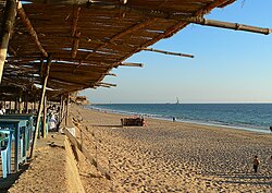
- Karachi Beach
- Qasim fort, Manora Island Karachi
- Kot Diji, Khairpur
- Bakri Waro Lake, Khairpur
- National Museum of Pakistan, Karachi
- Kirthar National Park, Thano Bula Khan, Jamshoro
- Karoonjhar Mountains, Tharparkar
- Shah Jahan Mosque, Thatta
- Tomb of Shah Abdul Latif Bhittai, Matiari
- Keenjhar Lake
- Lal Shahbaz Qalandar, Sehwan Sharif, Jamshoro
- Tomb of Mian Noor Muhammad, Benazirabad
CNIC Codes
- Hyderabad Division (41XXX)
- Karachi Division (42000-42501)
- Larkana Division (43XXX)
- Mirpur Khas Division (44XXX)
- Sukkur Division + Shaheed Benazirabad Division (45XXX)
See also
- Arab Sind
- Bagh Prints
- Brahma from Mirpur-Khas
- Debal
- Institute of Sindhology
- List of cities in Sindh by population
- List of cultural heritage sites in Sindh
- List of medical schools in Sindh
- List of districts of Pakistan
- List of Sindhi people
- List of Sindhi tribes
- Mansura, Sindh
- Mohenjo-daro
- Provincial Highways of Sindh
- Sind Division
- Sindh cricket team
- Sindhi clothing
- Sindhu Kingdom
- Sufism in Sindh
- Tomb paintings of Sindh
Notes
there is 90million only.
Bibliography
External links
- 31 May 2013 at the Wayback Machine
- Guide of 5 April 2012 at the Wayback Machine